
Vimy
| Vimy | ||
|---|---|---|
.svg)
|
|
|
| region | Hauts-de-France | |
| Department | Pas-de-Calais | |
| Arrondissement | Lens | |
| Canton | Liévin | |
| Community association | Lens-Liévin | |
| Coordinates | 50 ° 22 ′ N , 2 ° 49 ′ E | |
| height | 49-146 m | |
| surface | 11.33 km 2 | |
| Residents | 4,265 (January 1, 2017) | |
| Population density | 376 inhabitants / km 2 | |
| Post Code | 62580 | |
| INSEE code | 62861 | |
| Website | http://www.vimy.fr/ | |

Vimy ( Flemish : Wimi ) is a French commune and former cantonal capital with 4265 inhabitants (at January 1, 2017) in the department of Pas-de-Calais in the region of Hauts-de-France .
geography
Vimy is located in the coal basin in northern France about halfway between Lens and Arras . The place is at the foot of a ridge called the crête de Vimy . The neighboring municipalities include Farbus , Thélus and Givenchy-en-Gohelle .
history
During the First World War , the Vimy ridge was fiercely contested, especially in the spring and autumn of 1915 and in the spring of 1917. In the Battle of Arras in April 1917, Canadian units of the British Expeditionary Forces succeeded in taking most of the Vimy Height from the German Army. This important event in Canadian history is commemorated with the nearby Canadian National Monument Vimy . On the 100th anniversary around April 9, 2017, numerous commemorative events in Canada and France will commemorate the battles.
Vimy was the chief town ( chef-lieu ) of the canton of Vimy until the French territorial reform in 2015 .

town hall

church
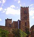
Vimy Castle

Canadian National Memorial in Vimy

Trenches


