Carvin
| Carvin | ||
|---|---|---|

|
|
|
| region | Hauts-de-France | |
| Department | Pas-de-Calais | |
| Arrondissement | Lens | |
| Canton | Carvin (main town) | |
| Community association | Henin-Carvin | |
| Coordinates | 50 ° 30 ′ N , 2 ° 58 ′ E | |
| height | 17-42 m | |
| surface | 21.03 km 2 | |
| Residents | 17,124 (January 1, 2017) | |
| Population density | 814 inhabitants / km 2 | |
| Post Code | 62220 | |
| INSEE code | 62215 | |
| Website | http://www.carvin.fr/ | |
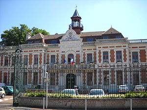
 Town Hall Carvin |
||
Carvin is a French municipality with 17,124 inhabitants (1 January 2017) in the department of Pas-de-Calais in the region of Hauts-de-France . It belongs to the Arrondissement of Lens , is the chief town (chief-lieu) of the canton Carvin and a member of the Communauté d'agglomération d'Hénin-Carvin .
geography
The municipality of Carvin is located in northern France, between Lille and Lens . The canalized Deûle (also: Canal de la Deûle) forms the southern border of the municipality of Carvin, to which the former miners' settlements Cité Saint-Paul and Cité Saint-Jean belong. Part of the village of Carembault also belongs to Carvin, hence the unofficial suffix -en-Carembault .
Carvin is bordered to the north by Annœullin and Carnin , to the north-east by Camphin-en-Carembault , to the east by Libercourt , to the south-east by Oignies , to the south by Courrières and Harnes , to the south-west by Annay , Estevelles and Pont-à-Vendin , to the west to Meurchin and to the north-west to Provin .
Population development
| 1962 | 1968 | 1975 | 1982 | 1990 | 1999 | 2007 |
|---|---|---|---|---|---|---|
| 16,139 | 17.097 | 15,601 | 16.206 | 17.059 | 17,767 | 17,485 |
Town twinning
Web links
- City website (French)


