Meurchin
| Meurchin | ||
|---|---|---|

|
|
|
| region | Hauts-de-France | |
| Department | Pas-de-Calais | |
| Arrondissement | Lens | |
| Canton | Wingles | |
| Community association | Lens-Liévin | |
| Coordinates | 50 ° 30 ' N , 2 ° 53' E | |
| height | 17-45 m | |
| surface | 4.64 km 2 | |
| Residents | 3,786 (January 1, 2017) | |
| Population density | 816 inhabitants / km 2 | |
| Post Code | 62410 | |
| INSEE code | 62573 | |
| Website | http://www.meurchin.fr/ | |
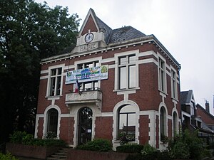
 Town hall ( mairie ) of Meurchin |
||
Meurchin is a French municipality with 3786 inhabitants (as of January 1 2017) in the department of Pas-de-Calais in the region of Hauts-de-France . It belongs to the Arrondissement of Lens and is part of the canton of Wingles . The inhabitants are called Meurchinois .
geography
Meurchin is located northeast of Lens in the coal basin of northern France on the Canal de la Deûle .
Meurchin is surrounded by the neighboring communities Bauvin in the north, Provin in the north and northeast, Carvin in the east, Estevelles in the southeast, Pont-à-Vendin in the south, Vendin-le-Vieil in the southwest, Wingles in the west and Billy-Berclau in the northwest.
history
In 890 the place is mentioned as Marcheim . The name later changed from Maxcin to Morcin (around 1150).
Population development
| 1962 | 1968 | 1975 | 1982 | 1990 | 1999 | 2006 | 2011 |
|---|---|---|---|---|---|---|---|
| 3,486 | 3,397 | 3,252 | 3,422 | 3,748 | 3,632 | 3,651 | 3,735 |
Attractions
- Saint-Pierre church
- Meurchin ponds

