Sallaumines
| Sallaumines | ||
|---|---|---|

|
|
|
| region | Hauts-de-France | |
| Department | Pas-de-Calais | |
| Arrondissement | Lens | |
| Canton | Avion | |
| Community association | Lens-Liévin | |
| Coordinates | 50 ° 25 ′ N , 2 ° 52 ′ E | |
| height | 27-54 m | |
| surface | 3.82 km 2 | |
| Residents | 9,715 (January 1, 2017) | |
| Population density | 2,543 inhabitants / km 2 | |
| Post Code | 62430 | |
| INSEE code | 62771 | |
| Website | www.ville-sallaumines.fr | |
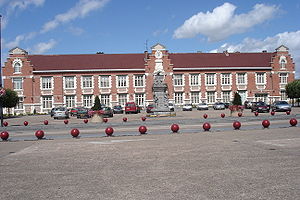
 The Sallaumines Town Hall |
||
Sallaumines is a municipality in the north of France (with 9,715 inhabitants Sallauminois called at January 1, 2017) in the department of Pas-de-Calais in the region of Hauts-de-France . The place belongs to the Communauté d'agglomération de Lens-Liévin , which consists of 36 communities with a total of 250,000 inhabitants.
geography
Neighboring municipalities are Méricourt in the southeast, Avion in the southwest, Lens in the west, Loison-sous-Lens in the north, Harnes in the northeast and Noyelles-sous-Lens in the east.
history
A defining event in the history of the region was the Courrières mining disaster on March 10, 1906, which killed 1,099 people.
| 1954 | 1962 | 1968 | 1975 | 1982 | 1990 | 1999 | 2006 | 2013 |
|---|---|---|---|---|---|---|---|---|
| 14,541 | 15,335 | 14,768 | 12,971 | 12,081 | 11,036 | 10,677 | 10,413 | 9,505 |
politics
mayor
Christian Pedowski has been the mayor of the municipality since 2014.
Twin cities
- Lugau , Germany (1965)
- Trbovlje , Slovenia (1965)
- Tores , Ukraine (1973)
- Wodzisław Śląski , Poland (1989)
traffic
The place is connected to the A21 (Lens – Douai) in the west and northeast . The N43 runs through Sallaumines .
Individual evidence
- ↑ Populations légales 2013 de la commune. Retrieved January 9, 2016 (French).
- ^ Les élections municipales 2014. Retrieved January 9, 2016 (French).
- ↑ Villes jumelées. Retrieved January 10, 2016 (French).
