Wingles
| Wingles | ||
|---|---|---|

|
|
|
| region | Hauts-de-France | |
| Department | Pas-de-Calais | |
| Arrondissement | Lens | |
| Canton | Wingles (main town) | |
| Community association | Lens-Liévin | |
| Coordinates | 50 ° 30 ′ N , 2 ° 51 ′ E | |
| height | 14-36 m | |
| surface | 5.93 km 2 | |
| Residents | 8,770 (January 1, 2017) | |
| Population density | 1,479 inhabitants / km 2 | |
| Post Code | 62410 | |
| INSEE code | 62895 | |
| Website | http://www.wingles.fr/ | |
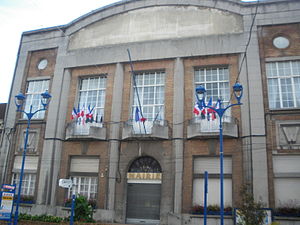
 Town hall ( mairie ) of Wingles |
||
Wingles (NDL .: "Westerwinkel") is a French municipality with 8770 inhabitants (as of January 1 2017) in the department of Pas-de-Calais in the region of Hauts-de-France . It belongs to the Arrondissement of Lens and is the main town ( chef-lieu ) of the canton of Wingles . The inhabitants are called Winglois .
geography
Wingles is located on the Deûle River .
Wingles is surrounded by the neighboring communities of Billy-Berclau in the north, Bauvin in the northeast, Meurchin in the east, Vendin-le-Vieil in the south, Bénifontaine in the southwest and Douvrin in the northwest.
The National Route 47 runs through the municipality .
Population development
| 1962 | 1968 | 1975 | 1982 | 1990 | 1999 | 2006 | 2011 |
|---|---|---|---|---|---|---|---|
| 9,332 | 8,946 | 8,348 | 8,472 | 8,742 | 8,691 | 8.211 | 8,239 |
Attractions
- Saint-Vaast church
- Memorial to the war dead
Personalities
- Émilienne Moreau-Evrard (1898–1971), resistance fighter
Web links
Commons : Wingles - collection of images, videos and audio files
Individual evidence
- ^ De Nederlanden in Frankrijk, Jozef van Overstraeten, 1969

