
Servins
|
Servins Sarwin |
||
|---|---|---|

|
|
|
| region | Hauts-de-France | |
| Department | Pas-de-Calais | |
| Arrondissement | Lens | |
| Canton | Bully-les-Mines | |
| Community association | Lens-Liévin | |
| Coordinates | 50 ° 25 ' N , 2 ° 38' E | |
| height | 135-183 m | |
| surface | 6.36 km 2 | |
| Residents | 1,093 (January 1, 2017) | |
| Population density | 172 inhabitants / km 2 | |
| Post Code | 62530 | |
| INSEE code | 62793 | |

Servins ( Flemish : Sarwin ) is a French municipality with 1,093 inhabitants (as of January 1 2017) in the department of Pas-de-Calais in the region of Hauts-de-France . It belongs to the Arrondissement of Lens and the canton of Bully-les-Mines (until 2015: canton of Sains-en-Gohelle ). Servins is a member of the Communauté d'agglomération de Lens-Liévin . The inhabitants are called Servinois .
geography
The municipality is located about 20 kilometers west of Lens in the Gohelle landscape . Servins is surrounded by the neighboring communities of Hersin-Coupigny in the north, Bouvigny-Boyeffles in the northeast, Gouy-Servins in the east, Villers-au-Bois in the southeast, Camblain-l'Abbé in the south, Estrée-Cauchy in the west and southwest and Fresnicourt- le-dolmen to the west and north-west.
Population development
| Population development | ||||||||
|---|---|---|---|---|---|---|---|---|
| year | 1962 | 1968 | 1975 | 1982 | 1990 | 1999 | 2006 | 2012 |
| Residents | 490 | 520 | 473 | 618 | 803 | 882 | 1,027 | 1.102 |
Attractions
- Saint-Martin church from the 18th century, monument historique since 1969
- Hannedouche Chapel, built in 1681 on the foundations of an earlier building from the 15th century, monument historique since 1989
- Stone cross, Monument historique since 1969
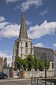
Saint Martin Church
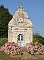
Hannedouche Chapel

