
Gladbach (Langenfeld)
|
Gladbach
City of Langenfeld (Rhineland)
Coordinates: 51 ° 7 ′ 0 ″ N , 6 ° 58 ′ 39 ″ E
|
||
|---|---|---|
| Height : | 63 m above sea level NN | |
Location of Gladbach in Langenfeld (Rhineland) |
||

Gladbach (with Hardt) is a district of Immigrath and Immigrath is a district of the city of Langenfeld (Rhineland) .
geography

Gladbach is to the east of the Troisdorf-Mülheim-Morsbroich-Opladen-Immigrath-Richrath-Speldorf railway , owned by the former Rheinische Eisenbahngesellschaft , a route on which freight trains and empty intercity trains run between the repair shop in Dortmund and Cologne today . In the north of the once important distance is trade , the former provincial road Elberfeld-Hitdorf that the Hitdorfer Rhine port with the Bergisch Land Association. Today this road, known north of Gladbach's Hardt , is classified as B 229 . In the south lies the district of Hardt, which has merged with Gladbach and (in terms of its own name, has almost completely disappeared). The Further Moor nature reserve lies across the A 542 . The eastern edge of the district is now the A 3 , in the past it was the former Leichlinger Sandberge , of which only remnants of the Kellerhansberg , Spürklenberg and Wenzelnberg have been preserved on the Langenfeld side. Gladbach is located on the Rhenish central terrace and is drained by the Gladbach , which flows through the district, and the Hardtbach in the south.
The older streets of Gladbach include the upper part of Gladbacher Strasse north of Bergische Landstrasse , Alt Gladbach , Auf dem Kämchen , Zur Bleiche , Am Wiesengrund , In den Klausen , In den Siefen , Zur Schlenkhecke , Am Jansenbusch , and on to the Kastanienallee , which is not named as such as well as the actual entrance to the Gladbacher Hof . The more recent streets can also be added: Rudolf-Kronenberg-Weg , Friedrich Kreusch-Weg , Julius Haas Weg , Karl Aschenbroich Weg , Jakob Böhme Weg and Hans-Sachs Weg .
The " Hardt ", as evidenced by current maps of the urban area, includes the lower part of Gladbacher Strasse south of Bergische Landstrasse , the western part of Hardt , the streets Am long Busch , Kaisersbusch , Zum Spürklenberg , Wacholderstrasse , Hagebuttenweg and Leichlinger Strasse east of the railway line . The Hardtbach , which crosses under the railway line in the area of Immigrather Platz , also rises and flows in this area . In the past, the term " Hardt " was also used to designate the forest that belonged to the Dückeburg hunting area up to the Schwanenmühle . In the 15th and 16th centuries there was still a wood cooperative for the use of the forest in the " Hardt ". In contrast, one associated nowadays with the " Hardt " the road Hardt with their southern as northern side streets past the junction of the A3 , junction box Weg . Furthermore, the Hardt street is occasionally referred to as Hardtstraße . These remarks on "Hardt" at this point only to make it clear that the districts of Gladbach and Hardt cannot easily be viewed separately from one another. And from the point of view of the former expansion of the forest in the " Hardt ", Gladbach can rightly be called a district in such a " Hardt " (namely, the Langenfelds).
history
General
Gladbach is one of the earliest written place names in Langenfeld. It was first mentioned as Gladebach in 1350/1370. The district was characterized by agriculture and forestry for centuries. First major companies settled with the weaving Neumann & Buren in 1864 and the Höveler force feed works on Immigrather station in the year 1908th Today, both companies no longer exist and their areas, and in the case of the weaving mill, their buildings , are used commercially. The Immigrath depot of the tram line between Langenfeld and Opladen of the Rhein-Wupper district's railways until it was closed in 1955 was once located on the site of today's aldi store. The buildings were then used until the demolition and subsequent construction of the aldi store Bus depot use.
The Gladbacher Hof
The Gladbacher Hof (see picture above) is mentioned for the first time in connection with a Margarete von Heiligendonk, who was abbess of Herdecke Abbey , also known as Nonnenherdecke , from 1371 to 1382 . She was enfeoffed with the court of Gladbach (Gladebach) in the Richrath parish , which she had previously owned as her own property. The Gladbacher Hof was mentioned in the record book of the Gravener court in 1547 . In addition, in the Topographia Ducatus Montani by the cartographer Erich Philipp Ploennies for the Monheim office from 1715, the Gladbach farm is located on a brook. 1782-1784 processed the barons of Bottlenberg gen. Boiler before the Higher appellate Julich-Berg against the Countess von der Horst about the purchase money for the Gladbacher Hof. In 1786 the house was renovated by Baron von Kessel. In addition, around 1890, the farmer Carl Halbach is listed as a tenant . In 1919 the building was opened by the co-founder of Kronprinz AG , Dr. Rudolf Kronenberg, acquired. Finally, since 1969 the farm has been owned by the city of Langenfeld, which was rebuilt in its previous form after a fire on February 24, 1997.
Old Gladbach
The oldest half-timbered buildings in Alt Gladbach are the houses at Zur Bleiche 4, 6 and 8. Some of the oak wood used as half-timbering still has the original infill with brushwood and clay . A living room ceiling called Cologne ceiling in the "good" room dates from the 18th century. Heavy boulders from the surrounding fields were used for the foundation . House No. 4 was completely renovated in 1985. The first inhabitants of the houses were pale farmers who washed the self-woven fabrics in the nearby stream and then laid them in the sun in the meadows to be bleached . In laundry factories was from these raw materials supply of bed linen and underwear made. The Bergisches Land was the sales area for the goods . The farmers brought cutlery for the proceeds . A grinding bowl was housed in house no. 8 until the mid-1950s . House no. 4 housed a small grocery store until 1975 .
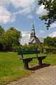
Characterizes the image of Hardt: The Church of the Redeemer
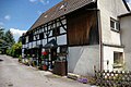
Gladbach's monumental street "Zur Bleiche"

Once the route of the field railway on the Kellerhansberg (?)

Art in public space: the swaths


Small railways in Gladbach
At the beginning of the 19th century, the demand for white sand in the building materials and glass industries increased. Sand pits were therefore set up in the area of Block , Kellerhansberg , Heidberg , Spürklenberg and Wenzelnberg , whereby the mountains Block and Heidberg , which once belonged to the Leichlinger Sandbergen, have now completely disappeared. In order to be able to transport the sand away, field railways with a gauge of 60 or 71 cm were built to transport the sand from the pits to Immigrath station . In 1905, the Othello union owned two steam locomotives with 25 HP and 30 HP and 50 dump trucks with a load capacity of 2000 kg each . And the brothers Mismahl decreed in 1908 a with a 14 horsepower gasoline engine equipped locomotive . According to the maps of the Prussian New Admission, the railroad lines ran over the Gladbacher Hof to the Immigrath station. The abandoned pits later served as landfills .
Soil structures on Hardt and Gladbach
Moats and ramparts between Bergische Landstrasse in the north, Gladbach in the east, Kaisersbusch in the south and the A 542 in the east deserve a special mention . On the one hand, there is a larger, roughly rectangular area in the small wood north of Zum Spürklenberg with further floor drawings. On the other hand, there are paths leading to this area from the direction of the A 542, which must have been deepened and planned. In addition, a square area surrounded by walls can be seen in the forest to the east of the path to the east . The extension of a path to Gladbacher Straße towards the south would flow into Möncherder Weg in Immigrath, which, according to oral tradition, is said to have been laid by monks and therefore has the name Mönch in its name.
In this connection, the question of how the accumulation of names with the component " monastery " in the Feldhausen and Wiescheid area could have come about is noted in this context . The names "Am Kloster", "Im Kloster", "Am Klosterbusch", "Im Klosterbusch", "Im Klostergarten", "Im Klosterfeld", "Zum Klosterbusch", and "Klosterbenden") can be found there. Even in the long investigation into the influence of external spiritual institutions on the history of the city, there are no answers to this. And even the dispute between the city historians Wyrich from Langenfeld and Klumpen from Leichlingen about a possible founding of a monastery either in Langenfeld or in Leichlingen in the Rheinische Post would not have brought clarity, said Müller. Incidentally, he did not mention the "Klosterstrasse" in Richrath.
According to an oral tradition that has meanwhile become known again whether the aforementioned scholarly dispute and the public discussion, monks are said to have founded a monastery in Langenfeld in 973 , but due to the murder of an imperial emissary , which is said to have been regarded as a bad omen Have given up foundation. The entourage then withdrew and founded the monastery a second time in 974 in Mönchengladbach . In any case, Fritz Clees suspected the founding of medieval masonry that the monastery was founded in Feldhausen. The floor drawings in Gladbach have given others reason to suspect that the monastery construction site may once have been there. Nevertheless, another consideration may be made at this point: Due to the discovery of Roman urns at Beerenbroich (in the direction of the Boneberger Bridge ), the location of the Roman camp , which the Romans built against rebellious Teutons on the right of the Rhine , could also be assumed at this point . Then the square area in the forest would have been a watchtower belonging to the fort . Be that as it may, all considerations are currently speculation , as explorations are still pending.
Individual evidence
- ↑ a b c d e f g h Rolf Müller, " Stadtgeschichte Langenfeld Rheinland ", Verlag Stadtarchiv Langenfeld 1992
- ↑ von Galera, Langenfeld (Rhld.), Von der Margrafschaft zur Stadt , Ofen, Langenfeld 1963
- ^ A b Environmental Protection and Beautification Association Langenfeld eV, A guide through the built history of Langenfeld
- ↑ Claus-Peter Peters, "Langenfeld im Wandel der Zeiten", self-published 2013
- ↑ ritter-pitter.de, on the founding of the monastery ( memento of the original from September 14, 2014 in the Internet Archive ) Info: The archive link has been inserted automatically and has not yet been checked. Please check the original and archive link according to the instructions and then remove this notice.
- ^ VVV eV, Peter Schmitz in the history of local settlements in the home book of the community Richrath-Reusrath , Hense Druck 1928, Facsimile Verlag Rheinlandia 1986
- ^ Friedhelm Görgens, Langenfeld , Droste, Düsseldorf 1984
literature
- Rolf Müller, Stadtgeschichte Langenfeld, Verlag Stadtarchiv Langenfeld 1992
- Friedhelm Görgens, Langenfeld, Droste, Düsseldorf 1984
- Friedhelm Görgens, Langenfeld 2, Droste, Düsseldorf 1994
- Claus-Peter Peters, " Langenfeld im Wandel der Zeiten ", self-published 2013, ISBN 978-3-00-035912-5
- Claus-Peter Peters, " The saga (s) of the sunken castle ", Books on Demand, Norderstedt 2005, ISBN 3-898-115623
- von Galera, Langenfeld (Rhld.), From the margraviate to the city, oven, Langenfeld 1963
- Environmental Protection and Beautification Association Langenfeld eV, A guide through the built history of Langenfeld
Web links
Districts: Langenfeld-Mitte | Immigrath | Richrath | Reusrath | Berghausen | Wiescheid
Locations and locations: Alt-Langenfeld | Brewhouse | Brandshof | Dückeburg | Feldhausen | Flachenhof | Fuhrkamp | Furth | Galkhausen | Ganspohl | Gieslenberg | Gladbach | Götsche | Götscher mill | Gravenberg | Hail cross | Hapelrath | Hardt | Hausingen | Hedge | Heinenbusch | Hoemann | Hucklenbruch | Hüsgen | Kämpe | Kaisersbusch | Limestone hedge | Katzberg | Cherry tree | Köttingen | Krüdersheide | Landwehr | Langfort | Corn flour | Neuburger Hof | Neurath | Ossenbruch | Rietherbach | Riethrather Hof | Riethrath Mill | Schelthoven | Schnepprath | Schwanenmühle | South | Stone rush | Stefenshofen | Turret | Virneburg | Wafert | Weißenstein | Widdauen | Angle | Wolfhagen | Customs House