Herrenreuth
|
Herrenreuth
City of Greiz
Coordinates: 50 ° 40 ′ 23 ″ N , 12 ° 13 ′ 52 ″ E
|
|
|---|---|
| Height : | 420 m above sea level NN |
| Residents : | 0 (2013) |
| Postal code : | 07973 |
| Area code : | 03661 |
|
Location of Herrenreuth in the city of Greiz
|
|
|
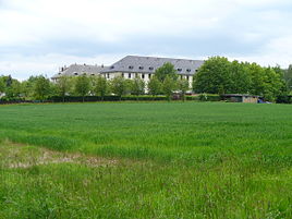
Town view: the two blocks used as residential buildings shortly before the demolition
|
|
Herrenreuth is a place in the district town of Greiz in the district of Greiz in Thuringia and belongs to the district of Pohlitz .
location
Herrenreuth is located about 300 m northeast of the Pohlitz district , on the right of Waldhausstraße (district road K 207) to Waldhaus , about 500 m south is the Raasdorf district . The forests around Greiz and Werdau, designated as a landscape protection area, begin north of the district road . The adjacent "Herrenreuth sports field" is already on Herrmannsgrüner Flur and thus belongs topographically to the municipality of Mohlsdorf-Teichwolframsdorf . The geographic height of the place is 420 m above sea level. NN .
history
In 1938 the construction of a barracks for the Wehrmacht began. Two blocks were completed in the shell, the third was the basement. The plan was to build a military training area for the 7th reconnaissance regiment in the Wergau forest. The property was used during the war as a location for the Home Guard Battalion II./654 and the State Rifle Battalion 621.
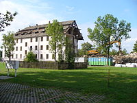
After the war, 51 apartments were completed in Block I in 1946, and Block II was expanded until the beginning of 1948. The third, unfinished block was demolished until 1949 for material extraction. The club of the allotment garden "Unity" was built at its location. In 2006/07 the previously renovated residential buildings were torn down. Since then, the district has only consisted of the garden and a waterworks and has no permanent residents.
literature
- Dieter Zeigert: Military buildings in Thuringia. A catalog of the barracks buildings with a detailed description of the military-historical circumstances in Thuringia since the German military constitution of 1821 . Ed .: Thuringian State Office for Monument Preservation and Archeology. Verlag Bildung + Wissen, Bad Homburg / Leipzig 1997, ISBN 3-927879-94-0 , Principality of Reuss younger and older line, p. 75-78 .
- The northern Vogtland around Greiz . A geographical inventory in the area of Greiz, Weida, Berga, Triebes, Hohenleuben, Elsterberg, Mylau and Netzschkau. In: Leibniz Institute for Regional Geography (Ed.): Landscapes in Germany . tape 68 . Böhlau Verlag, Leipzig 2006, ISBN 3-412-09003-4 , Raasdorf, from 1922 to Greiz, and Pohlitz with Herrenreuth, from 1921 to Greiz, p. 244-246, 398 .
- Volkmar Schneider: Greiz Home Calendar 2019 . 70 years ago - Herrenreuth settlement, S. 170 ff .
Web links
Individual evidence
- ↑ Official topographic maps of Thuringia 1: 10,000. LK Altenburg, LK Greiz, district-free city of Gera . In: Thuringian Land Survey Office (Hrsg.): CD-ROM series Top10 . CD 5. Erfurt 1999.


