Pansdorf (Greiz)
|
Pansdorf
City of Greiz
Coordinates: 50 ° 37 ′ 43 ″ N , 12 ° 7 ′ 7 ″ E
|
|
|---|---|
| Height : | 428 m |
| Residents : | 60 |
| Incorporation : | July 1, 1958 |
| Incorporated into: | Tremnitz |
| Postal code : | 07973 |
| Area code : | 036621 |
|
Location of Pansdorf in the city of Greiz
|
|
|
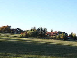
View of the place from the southeast
|
|
Pansdorf is a place in the district of Cossengrün / Hohndorf / Schönbach in the city of Greiz in the district of Greiz in Thuringia .
location
Pansdorf is located on the county road 206 between the western hamlet of Wellsdorf and the eastern Tremnitz on a plateau of the Thuringian slate mountains . The demarcation is very hilly and often interrupted by forests and bumps.
history
60 people live in the place mentioned for the first time on March 19, 1460. Until the 19th century, Pansdorf belonged to the Electoral Office of Plauen and from 1875 to the Saxon administration of Plauen . After the state structure in the GDR was dissolved, the place was incorporated into the Greiz district in the Gera district in 1952 . The place was incorporated into Tremnitz in 1958 . After 1990 there was no return to Saxony. From 1994 the place belonged to Hohndorf and from 1999 to the Thuringian municipality Vogtland Oberland . When it was dissolved in 2012, Pansdorf became part of Greiz as a district.
Web links
Individual evidence
- ^ Wolfgang Kahl : First mention of Thuringian towns and villages. A manual. Rockstuhl Verlag, Bad Langensalza, 2010, ISBN 978-3-86777-202-0 , p. 216
- ↑ Pansdorf in the Historical Directory of Saxony

