Reinsdorf (Greiz)
|
Reinsdorf
City of Greiz
Coordinates: 50 ° 38 ′ 21 ″ N , 12 ° 14 ′ 14 ″ E
|
|
|---|---|
| Height : | 393 m above sea level NN |
| Residents : | 487 |
| Incorporation : | June 30, 1994 |
| Postal code : | 07973 |
| Area code : | 03661 |
|
Location of Reinsdorf in the city of Greiz
|
|
|
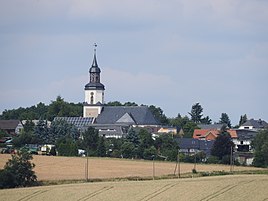
View from the south of the place
|
|
Reinsdorf is a district of Greiz in the district of Greiz in Thuringia .
location
South of Greiz on the federal road 94 and local roads you come to the district. It lies east of the Elsteraue on a tiered eastern flank of the Thuringian Slate Mountains . The area is loosened up with groves and clad edges. The Göltzsch flows down in the valley .
history
The place was first mentioned in a document in 1240. In the village chronicle, the date of December 1, 1380 is assumed without any references to literature. The first church was built in 1240, today's village church dates from 1720. In 1550, the school was built. Several sovereigns then exercised the administration.
On July 1, 1950, the previously independent community of Waltersdorf b. Irchwitz incorporated.
Web links
Individual evidence
- ^ Wolfgang Kahl : First mention of Thuringian towns and villages. A manual. Rockstuhl Verlag, Bad Langensalza, 2010, ISBN 978-3-86777-202-0 , p. 230
- ↑ Welcome to Reinsdorf. Archived from the original on January 10, 2014 ; Retrieved July 22, 2017 .

