
Matrica Castle
| Matrica Castle | |
|---|---|
| Alternative name | Matrica |
| limes | Pannonian Limes |
| section | 5 |
| Dating (occupancy) |
Trajanic - early Hadrian to early 5th century AD |
| Type | a) Cohort fort b) Equestrian fort |
| unit | a) Cohors I Lusitanorum ? b) Cohors I Alpinorum equitata c) Cohors milliaria Maurorum equitata d) Equites promoti |
| size | 152 × 155 m |
| Construction | a) wood-earth b) stone |
| State of preservation | The fort bath was largely preserved and restored. |
| place | Százhalombatta -Dunafured |
| Geographical location | 47 ° 18 '2.3 " N , 18 ° 55' 4.8" E |
| height | 98 m |
| Previous | Campona Fort (northeast) |
| Subsequently | Fort Vetus Salina (southwest) |

The Matrica Fort was a Roman military camp that secured a section of the Pannonian Danube Limes ( Limes Pannonicus ) as a cohort or cavalry fort . The complex, which has only been archaeologically examined in places, was built near the western bank of the Danube. It was located on an area south of Dunafüred, which was heavily swamped in antiquity, a municipality in the Hungarian Pest county that today belongs to the city of Százhalombatta . The extensive excavations in the southern necropolis and the relatively high number of inscriptions found are of particular importance for Pannonian research. The important findings at the fort bath prompted those responsible to preserve the building and thus keep it visible for posterity.
location

As early as the Bronze Age , traces of the so-called Vatya culture can be found north of the fort on the plateau above the Danube. Several treasure and depot finds were also known from this period. The most important pre-Roman site on the northern outskirts of the city was a large burial mound from the Hallstatt period , which has now been converted into an archaeological park . The city got its current name from these burial mounds, Százhalombatta means 100 mounds of earth.
However, the Roman engineers did not choose the flood-proof, higher-lying parts of the west bank for the fort, but built it in the slightly elevated southern edge area of a semi-oval depression open to the Danube, which at that time was still partially occupied by a wetland. The fortification was therefore built directly on the bottom of the depression in almost the immediate vicinity of the river bank, which is at great risk of flooding. From here, a section of the Danube and the opposite bank in the Barbaricum could be observed. The northern end of the depression is formed by the Benta brook coming from the north-west, which reaches almost the width of a small river on its lower course up to its confluence with the Danube.
In the southern part of the depression, not far from the ancient sites, a large area was claimed from November 1963 by the Danubian Oil Enterprise (DKV) and built on with an oil refinery . In addition, two large retention basins were created between the refinery and the fort . The archaeologist Judit Topál (* 1943) estimated that around 800 to 1000 Roman graves in this area fell victim to construction machinery without any investigation.
Research history
The ancient name has been preserved in the Roman imperial street directory Itinerarium Antonini and was also found in inscriptions in the excavation area of Százhalombatta-Dunafüred. The find area at the fort has been known for centuries. A stone sarcophagus was recovered from the southern burial ground as early as the 19th century. Even before the destruction of the next two centuries could set in, the Josephine land survey carried out in Hungary from 1782 to 1785 documented the well-preserved condition of the fort area at that time. The corresponding map shows very precisely the still undamaged rectangular floor plan of the garrison. It is also clear that, in contrast to today, the Danube still flowed by some distance away. The excavations that began in the 20th century, on the other hand, are hindered by modern ramparts. These were created in 1809 during the Napoleonic Wars (1792–1815). At that time, in the area of the camp and its civil settlement, the vicus , mighty entrenchments and cannon positions were thrown out of earth, some of which have survived the times. The activities of a local motocross club in the late 20th century were certainly not conducive to maintaining the substance. Due to the fortification work in the 19th century, only the north-west and south-east corner of the fort, close to the Danube, remained untouched before the interventions.
In 1941 the remains of a vicus building were discovered in the course of a canal construction project for flood protection in Dunafüred. The archaeologists who were called in, Károly Sági (1919–1997) and Aladár Radnóti (1913–1972) documented the findings in 1942 properly. In the war year 1943, unsystematic explorations were carried out south of the fort by the Stuhlweissenburg museum director Árpád Dormuth, which, together with Sági's findings, was only discovered from 1953 through the excavations of the archaeologist Éva B. Bónis (1919–1999) and the archaeologist, ancient historian and epigraphist András Mócsy (1929– Mócsy) 1987) could be evaluated and supplemented. Mócsy also dug in Százhalombatta-Dunafüred in 1955. In 1963 the archaeologist Edit B. Thomas (1923–1988) worked on the excavation of a pointed trench in the south of the fort. Her work was followed by rescue excavations in the vicus and the uncovering of the fort bath, initially under the direction of Sági, and from 1971 under Topál. Topál was also responsible for investigations in the early and middle Imperial burial grounds until 1974. Further excavations in the fort area itself took place in 1993 and from 1995 to 1997 by the historian and archaeologist Péter Kovács (* 1969). In addition to the large excavation campaigns, smaller rescue excavations had to be undertaken again and again.
Building history
Wood-earth warehouse
The predecessor warehouse, which was constructed using a wood-earth construction, remained undiscovered for a long time. A pointed ditch examined by Thomas in the south of the fortification in 1963 had typical features that made it possible to assign it to a wood-earth fort, but at that time it was still open whether this ditch preceded the already known garrison built in stone or at the same time duration. It was not until Kovács' research between 1993 and 1994 that the existence of a previous wooden building could be proven beyond doubt. This was in the same place as the later stone fort and had the same dimensions. The subsequent studies by the Hungarian ceramic specialist Dénes Gabler based on the found terra sigillata proved to be the decisive basis for the dating . In all likelihood, a piece could be assigned to a South Gallic workshop in Banassac , France . This pottery site gained importance in the late 1st century and disappeared from the market again in Hadrianic times. Gabler was thus able to limit the construction of the wood-earth warehouse to the reign of Emperor Trajan (98-117) or to the early reign of Emperor Hadrian (117-138). The wood-earth phase ends with a layer of destruction.
Stone fort
Enclosure
The archaeologist Gyula Nováki determined during his excavations a 152 × 155 meter, almost square floor plan of the subsequently built stone fort, which, according to the building inscription listed below and other evidence, was only built after the Marcomann Wars (166-180). As Gabler explained, the new building had become necessary after it had been destroyed during these wars. The complex has the "playing card shape" typical of military installations from the Middle Imperial period with rounded corners, each with a watchtower. The fence was broken through on all four sides by a gate and its praetorial front, the narrow side facing the enemy, faced the Danube.
In the 1950s, Mócsy examined the accessible sections of the defense system in the southeast. The defensive wall between the southern gate, the Porta principalis dextra , and the southeast corner tower on the river bank had a 0.85 meter wide core masonry, to which a front of 0.2 × 0.4 meter square hand blocks was hidden on the outside. The two-lane Porta principalis dextra , which was divided by a central pillar (spina) , had a rectangular gate tower on each of its two flanks that protruded half its width from the wall structure and had a base area of 3.2 × 4 meters. Well protruding towers only became more and more the usual norm in Roman military architecture from the middle of the 2nd century. Additional shooting windows integrated into the protruding gate structures, for example, made it easier to observe and defend the entrances. In contrast to some of the neighboring fortifications and other known camps, the south gate was not walled up afterwards.
In the course of the construction of the camp, an almost square, 4 × 4.2 meter corner tower was erected on the preserved, rounded southeast corner of the fort wall. On the other hand, the semi-circular intermediate tower let in between the gate and the corner was created later. U-shaped towers can usually be assigned to a late antique building program. In Matrica, as in other garrison types, the mid-imperial fort ditch that had surrounded the camp was filled in before the intermediate tower was built. Subsequently, the new tower protruding further out of the wall structure superimposed the former moat area. Instead of the old defensive trench, a double trench was dug in front of the new tower, which could be demonstrated in profile on the southeast corner by Dormuth. After his excavations, Mócsy suspected the reconstruction of the garrison in the reign of Emperor Caracalla (211-217), based on the doctrines of the time (see also Contra Aquincum ). The archaeologist Endre Tóth (* 1944) did not follow this idea. For him and other researchers, the U-shaped towers belong to the 4th century. Since the double trench was also backfilled and compacted in late Roman times, discussions took place in research as to whether Matrica had not been rebuilt after this leveling work.
During the excavations in the 1990s, the north-western corner of the fort could also be examined. There was a fan-shaped corner tower typical of the late Roman presence. Many older forts along the Danube Limes received corresponding new bastion-like corner towers in late antiquity. A coin from the reign of Emperor Constantine II (337–340) recovered from the Baracspuszta fort in connection with these modifications could provide the term post quem . During the excavations at that time, the Porta principalis sinistra opposite the Porta principalis dextra in the north was uncovered and the floor plan of the main gate in front of the Danube front, the Porta praetoria, became known. The river, which has come dangerously close to the fort area in the past centuries, has not yet damaged the Matrica garrison - in contrast to many other fort sites.
In the post-Valentine period , the towers of the Porta praetoria and the Porta decumana as well as the southeast corner tower received extensions.
Principia
At the intersection of the main streets that led from all four gates at right angles into the interior of the camp were the 47 × 35 meter Principia , which were excavated in the 1990s, and the fortification staff building in whose wall a mortared denarius from 158 AD was stuck. The Principia in Matrica corresponded to the largely standardized, mid-imperial floor plan. The vestibule built across the Via principalis was added later - according to Kovács possibly in the 1st half of the 3rd century - the square, 16.5 × 16.5 meter large inner courtyard had well-preserved paving and a 7 meter height deep stone-cased wells. The excavators uncovered the armamentarium (armory) in the south wing and a basilica in front of the rear, western wing . This was initially accessible directly from the outside through a narrow entrance on its south side. However, this door was later walled up. Kovács pointed out that other staff buildings like the one in Aalen may have had side entrances. Behind the basilica , in the middle of the central axis of the Principia, the flag sanctuary was built in with a semicircular apse , to which a suite of rooms with three chambers each followed to the left and right. In a later time the dividing walls of the three rooms south of the sanctuary were torn down and a large room was created. The original terrazzo flooring in these rooms has been renewed five times, four times of which terrazzo has been laid. The fifth of these six floors was designed as a brick floor and could be assigned to the late Roman period. The basement of the flag shrine, in which the troop treasury once stood, was 3 × 1.5 meters in size. The basement stairs, which were originally oriented towards the apse, were later moved in the opposite direction. Now the cellar, whose 1.8 meter high, vaulted ceiling was preserved, was accessible from the entrance of the sanctuary. Kovács found several denarii here. According to a coin belonging to the imperial wife Salonina († 268), the basement was filled after 260. The clay floor of the sanctuary was renewed once during the Tetrarchy . In the post-Valentine period, the castle occupation leveled the Principia and closed the fountain in the courtyard with stones. A mud-brick house was built on the site of the staff building. The conversion of the area at the former flag sanctuary into a waste pit was remarkable. This pit intersected the previous floor levels. From it Kovács recovered a coin from Valentinian, a glazed mortar, a fragment of a grid pattern, a crest decorated with a circle and a stamped brick from Frigeridus dux.
Building inscription
For the history of the Pannonian Limes, a building inscription dating from 180 to 183 AD is important, which came out of the ground in the storage area. An identical copy was also found in the Limes Fort Intercisa . The two inscriptions bear witness to a major building program under Emperor Commodus (180–192) to secure the borders after the Marcomann Wars. The opponents in this border area, in this case the Sarmatians , who are difficult to assess for Rome , are called robbers . The indications tribunicia potestate VI / imperator IIII (180 AD) and consul IIII (183 AD) do not match in the two inscriptions. There is obviously a spelling mistake by the stonemason. The tenure of Lucius Cornelius Felix Plotianus is located between 183 and 185 AD.
- Imp (erator) Caes (ar) M (arcus) [Aur (elius) Commodus An] -
- toninus Aug (ustus) pius Sar [m (aticus) Ger (manicus)]
- Brit (annicus) pont (ifex) max (imus) trib (unicia) pot (estate) V [I imp (erator) IIII]
- co (n) s (ul) IIII p (ater) p (atriae) ripam omnem b [urgis]
- a solo extructis item praes [i] -
- dis per loca opportuna ad
- clandestino latrunculo-
- rum transitus oppositis
- munivit per L (ucium) C [ornelium]
- F [elicem Pl] ot [an] u [m leg (atum) pr (o) pr (aetore)
Translation: “The Emperor Caesar Marcus Aurelius Commodus Antoninus Augustus Pius, Sarmatian winner, German winner, Britannian winner, high priest, holder of tribunician power for the sixth time , emperor for the fourth time, consul for the fourth time, father of the fatherland, has all Burgi from him on the riverbank from, then attached the forts at the opposite locations in order to forestall the passage of roaming robbers, by Lucius Cornelius Felix Plotianus, governor. "
Troops and military personnel
In 2001 the epigrapher Barnabás Lőrincz (1951–2012) put together his troop list for the Principate's time for Pannonia. For Matrica the following picture emerges over the centuries, which is supplemented here by a late antique unit - although not mentioned by Lőrincz.
| Time position | Troop name | comment |
| until AD 118/119 | Cohors I Lusitanorum ? | The 1st cohort of the Lusitanians appears in the cohort lists of military diplomas for this period. Its location is unknown but is believed to be in Matrica until AD 118/119 . Subsequently, the troops could have been assigned to the Kölked Fort (Altinum) in the south between 118/119 and 1808 . In the year 167 AD the cohort still appears in the Pannonian troop lists, possibly it also took part in the Marcomann Wars (166-180). Subsequently, the Lusitanians evidently did not return to Altinum , but were perhaps relocated to the Szekszárd castle, which has not yet been archaeologically proven, a little further north . |
| after 118/119 AD | Cohors I Alpinorum equitata | From 41 (?) To 54 the 1st cohort of the Alpine countries was in the Danube fort Dunaszekcső (Lugio) and was possibly assigned to Carnuntum from 54 to 69 . Between 70 and 101 it can be traced back to the Hungarian inland fort Gorsium , from where it was then moved from 101 to 118/119 to Vetus Salina on the Danube Limes. At the same time, however, a cohort of the same name existed, from 103-106 in Moesia superior (Upper Moesia ). After that, the "Alpine residents" did their job in Matrica and lay here until the outbreak of the Marcomannic Wars. |
| from 180 AD | Cohors milliaria Maurorum equitata | The partially mounted double cohort of the Moors is probably in the year 171 for use in the Marcomann Wars at the same time as the Cohors quingenaria Maurorum equitata (partially mounted cohort of the Moors) in the Roman province of Pannonia superior (Upper Pannonia) from soldiers of the equites Afrorum et Maurorum (African and Moorish riders ) has been set up. After the end of the fighting, the unit was assigned as a new core force for Matrica . Here the Moors left some inscriptions and brick stamps in the vicinity of the garrison .
The troupe was honored three times in total:
|
| 4th century | Equites promoti | For the late period of the fort, a cavalry unit of light (or selected) cavalry for Matrica is recorded in the list of troops in the Roman state manual Notitia Dignitatum . |
Commanders of the Cohors I Alpinorum
| Surname | rank | Time position | comment |
| Publius Afranius Victor | Praefectus cohortis | A.D. 120 to 150 | Publius Afranius Victor , who belonged to the Romanized population and who died at the age of 50, left behind his wife Claudia Ingenua, who had him buried in the southern grave field (grave 153). Possibly he was still in active military service as he is not referred to as a veteran . |
Commanders of the Cohors milliaria Maurorum equitata
| Surname | rank | Time position | comment |
| Quintus Cornelius Secundus | Praefectus cohortis | A.D. 198 to 209 | The prefect, son of Quintus, who belonged to the knighthood , came from the civil district of Arnensis in what is now central Italy . The honorary altar donated by him for the then emperor was probably built in 202 when Septimius Severus visited the two Pannonian provinces. |
Vicus

As the votive altar of the legionnaire Aelius Victor, which was discovered in the camp village and was erected in AD 267/268, testifies that the responsible cives Romani (Roman citizens) in Matrica administered not only an area under them (territorii Matricensium) , at least in the 3rd century , but apparently had also created institutions that worked on the municipal model. The transcription of the Latin text follows the presentation in the compendium "The Roman Inscriptions of Hungary" (RIU) 6, No. 1429. Civeromanorum is a vulgar Latin form of civium Romanorum :
....]
[pro salute]
civerom [an]
or (um) (!) territ (orii)
Matric-
ensium
Ael (ius) Vic [t] -
or vet (eranus) [leg (ionis)]
II ad [ i (utricis)]
Pater [no et]
[... co (n) s (ulibus)]
[v (otum) s (olvit) l (ibens) m (erito)]
The area of the partly elaborately developed and very extensive camp village is only known in places. It turned out that at least some of its residents were able to maintain a certain luxury. Civil development was found north and south of the fort on the two major arterial roads along the Danube. The area to the north of the fort has become a highlight of the excavations in Matrica, in addition to several rescue excavations, in particular due to the exposure and conservation of the fort bath. The width of the northern vicus from the Danube to the west was around 400 meters. The flood protection canal, which drains into the Danube from west to east, immediately south of the baths, was dug in 1941. Not only were the remains of a villa-like building (stone building VI after Mócsy) examined by Sági and Radnóti cut through, but also the Limes road leading from the north into the fort. Stone building VI was around 100 to 150 meters from the garrison. The archaeologists determined that the multi-phase structure consisted of two parts, the eastern part of which was completely destroyed. The second, only partially preserved construction phase stood almost exactly in a north-south direction. A room with an apsidal closure had canal heating, which was typical from the 1st half of the 3rd century . The adjoining room could also be heated. The two lighting points ( praefurnium ) for these rooms were still in good condition. Fragments of wall paintings recovered from the rubble testify to the dignified furnishings of this house, as do the terrazzo floors of good quality.
In 1953 three early pit houses and six stone buildings (I – VI) were uncovered in the north vicus . Bónis and Mócsy dated the oldest mine house on the basis of the finds, in particular the stamped fragments of sigillata, to the late Flavian or Trajan era. The latest sigillates from this building come from the workshop of the Westerndorf manufacturer Elenius. According to the findings, this pit house - and possibly the other pit houses as well - was backfilled and the ground leveled before the end of the 2nd century. The excavators speculated that these construction activities took place after the Marcomann Wars. Following this phase, the stone expansion of the vicus can be observed. The stone-built multi-phase house I stood out from the other stone buildings due to its size and villa-shaped design. The salvage excavation only made it possible to uncover its southern part. Even probes that were supposed to measure its full dimensions could not really complete the picture. It turned out, however, that this building had originally been built as a multi-room house, below whose floor level two well-developed sewers met and flowed off in a south-easterly direction towards the Danube. Of House VI Sági and Radnóti had already examined in 1942 two rooms before the new digs were recognized. In House III a narrow wall made of dry stone was found, under which a small bronze coin from the reign of Emperor Valentinian I (364–375) and a bone tessera lay. Mócsy dated this building to the 2nd half of the 4th century. Overall, the archaeologist was able to determine up to six different construction periods in the vicus . In addition to these findings, at least two trenches and traces of a wattle fence were uncovered in the southern camp village, which testify to the enclosure of the vicus .

In July 1984, under the direction of Katalin Ottományi, an emergency excavation had to be carried out in the north vicus, which again affected the area of the ditch built in 1941, because the local water sports club wanted to build a sewer ditch that led into the large ditch. The excavators then examined a section 100 meters long and six meters wide. This time no stone buildings could be found, but next to the remains of the pit houses a deep storage pit, hearths and part of a water pipe came to light. The large amount of found material was remarkable. Among other things, around 130 sigillates as well as glass and fresco fragments were found. Of the six coins found, the oldest was from the reign of Emperor Hadrian, four from the 3rd century.
A road station ( mansio ) was also discovered in the vicus area. The partially hypocausted building had a bathroom with four semicircular apses and a walled inner courtyard. Several sewers showed its complex structure. The rooms were equipped with terrazzo floors.
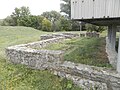
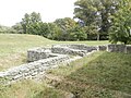
Fort bath
A 40 × 18 meter, multi-phase fort bath was built around 250 to 300 meters in front of the north wall of the garrison. The first excavations took place in 1876. At that time, hollow bricks for wall heating, lead pipes and painted plaster fragments as well as bricks with the stamp of the Legio II Adiutrix were brought to the Hungarian National Museum in Budapest.
The facility, which was exposed again by 1973, was hypocausted , had a sewer system, a multilayer brick floor and was equipped with terrazzo floors . The walls of the bath were 60 to 80 centimeters wide and had foundations that reached 80 to 90 centimeters into the ground. In some sections, the rising masonry was still 10 to 20 centimeters high and had remains of fresco painting. During the renovation work, some stones decorated with reliefs were also used for secondary purposes. The excavators were also able to uncover two larger pits that were rich in finds. The bath was in use from the second half of the 2nd century to the middle of the 4th century.
- Fort bath


Burial grounds

The Limesstraße leaves the fort from the south gate and then follows the course of the Danube bank at a constant distance. The traces of the route could be traced to around 100 meters with the help of aerial photo archeology. A little further south from Topál between 1971 and 1974, a mid-imperial necropolis with 213 graves, which had already been severely destroyed by modern building measures, was systematically examined. The first burials date from the last decade of the 1st century. Continuous use ended at the end of the 3rd century. Subsequently, for around 50 years, burials only took place in the newly designated grave field north of the fortification. Only graves from the late 3rd and 4th centuries could be examined here. The southern necropolis was last used again for around 20 years from the middle of the 4th century, as attested by a smaller group of graves. During the investigations in the south of the fort, the excavators also observed an 8 to 10 meter wide strip of open land that ran through the cemetery grounds from north to south. It was interpreted as a remnant of the former Limes road.
The 213 preserved burials of the southern necropolis were divided into 178 cremation graves, 33 body graves and two no longer identifiable burials. The clearly identifiable cremation graves showed the following groups:
| Grave type | Brief description | 100% share |
|---|---|---|
| fire-discolored grave pits | lined with clay | 50.28% |
| fire-discolored grave pits | without clay lining | 24.58% |
| Grave pits without discoloration of the fire | without clay lining | 12.85% |
| Bustum graves | 3.35% | |
| Urn graves | 2.23% |
Topál assumed that the fire-discolored graves were ritually cleaned with fire before burial, from which the traces of the burn originated. Real bustum graves, in which the funeral pyre was erected over the grave pit, were almost rare in Matrica, in contrast to the former type.
The archaeologist structured the uniquely identifiable body graves as follows:
| Grave type | Brief description | 100% share |
|---|---|---|
| simple grave pits | Burial in a stretched supine position | 42.43% |
| simple grave pits | Burial in a crouched position | 15% |
| Chamber graves or stone slab graves | 18.18% | |
| Brick graves | 6.06% |
The typical grave goods in the south cemetery, especially the cremation graves, included utility ceramics. The relatively large number of terra sigillata (13.15 percent) and the high proportion of clay oil lamps (110 pieces) were striking . In addition, the proportion of glass remained very low at 22 pieces. A total of 48 coins were recovered in 46 graves. A fibula from grave 107, which may have belonged to the costume of the native Celtic Eravisker , was considered a special feature . Overall, the range of fibulae includes Roman, native and Germanic forms. A Roman ring pommel sword of the Biborski II type was found in grave 14. A sword blade was discovered in grave 93. It lay under the head of a child buried there. Topál assumed that the different burial rites would reflect the origins of the people. However, this assumption was assessed as too general in international reviews.
Around 100 to 150 meters in front of the north gate of the fort, a ditch runs from west to east and a high dam behind it and along the Danube, which is supposed to protect Dunafüred from flooding. On the north side of this dam, two churned-up brick graves from the 3rd century came to light in 1973 near the ancient Limes road. A stone fragment of a satyr was found nearby . In 1984 two skeletal graves next to each other were discovered again north of the ditch at the sports field of a club. The dead were buried in the opposite direction.
Post-Roman development
With the end of the Pannonian provinces gradually emerging as a result of crises and the migration of peoples, the Roman settlements became neglected and were largely abandoned. The grave of a Hun , which was found in the vicinity of the south-eastern corner tower of the fort, can be described as a trace of this epoch, which was riddled with persistent violent events . The finds from this burial included a silver and a bronze brooch, a belt lock and a Roman glass with a faceted surface, which dates from between 380 and 430.
As can be seen at some sites (e.g. Zeiselmauer-Wolfpassing , Böhming and Kösching ), a village church with a cemetery for the desert of Báté was built in the Middle Ages on the area of the Principia .
Other important finds
Some finds show that Matrica was inhabited until the 5th century. A bronze mirror votive with three graces, which was made in the 2nd or 3rd century, became known as a possible depository find. In total, several very similar mirrors were discovered. Militaria was also recovered.
Stone monuments
Main article: Roman stone monuments from Százhalombatta-Dunafüred
The excavation sites encompassing the fort area, the surrounding camp village (vicus) and the necropolis are known for their relatively rich inscription finds.
Brick stamp
The stamps of the Moorish cohort and the Legio II Adiutrix have become known from Matrica . In addition to these bricks with troop stamps, there were also two stamp types of the Lupicinus military tribune, which was active in late antiquity. According to Lőrincz, Lupicinus was active as a tribune after 368 and before 377. Bricks with his stamp were found at some military sites in the Pannonian Danube Limes , in particular in the past in the larger area around the Danube Bend ( forts of Pilismarót , small fort Kisoroszi , Burgus Verőcemaros-Dunamező and Burgus Szigetmonostor-Horány ). At that time, the expansion program of the Danube Limes under Emperor Valentinian I (364–375) reached its peak.
River finds
From a gravel bank several meters thick near Százhalombatta, a crawler excavator used to deepen the bed of the Danube unearthed long wooden planks that could possibly have belonged to a Roman shipwreck. Their exact nature is not known, however. Thomas considered the Roman origin of the planks to be proven and, in connection with this find, mentioned 35 bronze vessels from the early Roman imperial period that they attributed to the equipment of a ship's kitchen. The ceramics, which were excavated at the same time as the woods, had the same time position as the bronzes. In the case of a Roman shield hump, which was also discovered, it was not possible to prove that it belonged to the ship's inventory with complete certainty. In terms of their design, the finds were typical of the end of the 1st century or the beginning of the 2nd century.
Lost property
Many finds, especially most of the stone monuments, are in the Matrica Museum in Százhalombatta. Other found goods were also brought to the Hungarian National Museum in Budapest . The milestone of the emperor Severus Alexander came to the St. Stephen's Museum in Stuhlweissenburg .
Limes course between the Matrica fort and the Vetus Salina fort
| route | Name / place | Description / condition |
| 5 | Százhalombatta-Dunafüred (Burgus Matrica 1) | After the Limes road has left the south gate of Matrica, its route continues in the Dunafüred valley for around 1.5 kilometers along the Danube to the south. It has not been accessible on this section and the following kilometers since the 1960s, since the banks of the oil refinery have been located there since that time. At the end of the depression - when you leave the cemetery - a junction bends to the west and climbs along the western flank of a Bronze Age fortification through a narrow ravine to a loess plain , which is now dominated by the refinery. As the archaeologist Sándor Soproni (1926–1995) noted, the Limes Road reached the plateau on the western flank of the prehistoric earthworks. There is a deep water channel that has been continuously eroding since ancient times, which has created the small Hosszú valley. An aerial photo from 1962 shows the Roman road there, which Soproni was also able to follow in the field for a while. A relatively large number of milestones from the 3rd century were recovered from the area of the valley where the ancient route reached the edge of the plateau, indicating the distance as either 22 or 23 Roman miles (around 32.5 or 34 kilometers) to Aquincum Show. Soproni succeeded in determining the original locations of the stones that had become known by 1983. The stones gathered at the edge of the plateau were evidently brought in from the area around Matrica in the 4th century in order to secure the road against the erosion ditch approaching to the side.
The first milestones emerged in 1967. The partially fragmentary pieces come from the reign of Emperor Maximinus Thrax and his son Maximus Caesar (22 miles to Aquincum), Philip Arabs (244–249) and his wife Marcia Otacilia Severa (23 miles to Aquincum), Philip and his son Philip Caesar (22 miles to Aquincum), Valerian (253-260) with a destroyed mileage and from the time of the Tetrarchy (22 miles to Aquincum). Next to it was a piece that was left unmarked. The stone of Maximinus Thrax was later provided with a palimpsest inscription of the emperor Florianus (276), who ruled for less than a year . Another milestone originating from this very spot names the emperor Severus Alexander (222–235) and dates to the year 229. Unfortunately, the expected mileage to Aquincum was also not preserved. Also in the same place, three stones were discovered again in 1971. One who indicates 23 miles to Aquincum comes from the reign of Emperor Elagabal (218–222) and names the then Lower Pannonian governor Tiberius Pontius Pontianus . The ancient historian Michael Rathmann (* 1968) assumed that the governor - like other office colleagues - had his name stamped on the milestones without authorization. Next to this stone was another piece of the Maximinus Thrax with a fragmentary indication of miles, one of Gordian III. (with broken miles) and one of Claudius Gothicus (268-270), who said 23 miles to Aquincum, was found. In 1994 another milestone by Valerian and a tombstone emerged from the ground at the same place (23 miles to Aquincum). The excavators also suspected a villa rustica in this area . The archaeologist Zsolt Visy (* 1944) wondered whether there could have been a Roman watchtower on the edge of the plateau and named an aerial photo that showed an L-shaped trench section on the spur of the northern slope, which might have belonged to a post. In addition to the route leading up the slope, which according to a survey of the 19th century, when the plateau was reached, followed a southerly direction as if drawn with a ruler up to almost three kilometers from Vetus Salina, a second Limes road branching off at the foot of the loess slope was possible to be established. It led below the height and ran up to half the distance to Vetus Salina always directly on the high bank along the Danube. This route then flowed back into the main arm of the long-distance connection. |
| 5 | Ercsi North (Burgus Matrica 2) | To the north of the city of Ercsi, another Roman-era path branches off at a very acute angle from the Limes road leading to the south. This northward path accompanies the Limes Road to the west for a short time and then turns north-east to the nearby, 50-meter-high loess plateau. There was a long-known watchtower with a single, square moat, high above the Danube. From this point the Roman guards could see as far as Aquincum (Budapest) and far into the Great Hungarian Plain , which belonged to the Barbaricum and was inhabited by the Sarmatian Jazyans . A secondary Roman altar stone comes from the tower.
200 meters further south is a chapel with the burial place of the noble von Eötvös family. The otherwise unusual construction of a separate road to a watchtower led to the consideration of whether there might not have been a larger military post in the Ercsi area that was connected to this road. But so far no proof has been found for this thesis, although Roman graves were found on the western edge of Ercsi, which could indicate an obvious settlement. |
| 5 | Ercsi (Burgus Matrica 1) | According to Visy, it is fairly certain that there was another watchtower at the junction of Limesstrasse, which runs directly on the banks of the Danube, in the urban area of Ercsi. |
| 5 | Szigetujfalu (Burgus Matrica 13) | A Roman military station to the southeast on the opposite bank of the Danube was also in visual contact with the watchtower of Ercsi. It was identified by the archaeologist Flóris Rómer (1815–1889), who was important for Hungarian research, in the area north-west of Szigetujfalu. The researcher drew and described the structural remains that were near the ferryman's house at the time. The ice debris from the river had already severely damaged the strong stone walls. Roman ceramics were found in the rubble. The wall that was still visible was similar to that of the Dunakeszi Ländeburgus and was 20 fathoms (37.93 meters) long, while the two walls that reached to the bank were 7 fathoms (13.28 meters) in length. The facility, which is now under water, has not yet been scientifically investigated using modern means. |
| 5 | Sinatelep (Burgus Matrica 4) | An aerial photo from 1940 near the village of Sinatelep and south of Ercsi reveals that the Limes road follows the course of the modern road no. 6 almost exactly. In the northern corner of the right-angled junction from the road to Sinatelep is a long-known, approximately 8 × 8 meter rectangular tower, probably built in wood, surrounded by a 38 × 38 meter ditch. The aerial photo from 1940 still shows an eroded 60 × 60 meter bright strip around this facility, the function of which has not yet been analyzed due to the lack of excavations. |
| 5 | Sinatelep (Burgus Matrica 5) | Only a little south of the local approach to Sinatelep, west of the modern road bridge over the Váli Brook flowing from the northwest into the Danube, remnants of the Roman route and three milestones were discovered at the beginning of the 19th century, which indicated a distance of 34 miles to Aquincum. To the south-east of this point, near the northern edge of the brook near its confluence with the Danube, a 4 × 4 meter large Roman watchtower was examined in the 1930s. A coin from the reign of Valens , which was minted between 367 and 375 AD, is one of the important datable finds. Again to the north of this point, on a flat ridge between the Burgus and the watchtower, there was a civil settlement, which has been proven by small finds. An old map still shows structural remains at this point. |
| 5 | Váli Bach (Burgus Matrica 6) | To the north of the confluence of the Váli brook into the Danube, ancient pottery shards and rubble could point to another watchtower that must have been located directly on the western bank of the river. |
| 5 | Szalma csárda (Burgus Matrica 7) | Three Roman milestones have been found near the Limes road, on the south bank of the stream coming from Iváncsa. Later, the archaeologist Arnold Marosi dug a 4 × 4 meter watchtower east of the historic route, in the immediate vicinity of the Danube bank, on the apex of a hill. |
| 5 | Adony-Iváncsa (Vetus Salina, North Fort) | In 1969, north of the stone fort of Vetus Salina, immediately west of the road no.6 at the junction to Iváncsa, the outlines of a rectangular wood-earth warehouse measuring around 230 × 270 meters were recorded from the air, but still there no research has been done. |
| 6th | Adony | The Vetus Salina fort, which was largely destroyed by the Danube, is located on the northern edge of today's settlement. |

Monument protection
The monuments of Hungary are protected under the Act No. LXIV of 2001 by being entered in the register of monuments. The Roman sites of Százhalombatta-Dunafüred and the surrounding area belong to the nationally valuable cultural property as archaeological sites according to § 3.1. According to § 2.1, all finds are state property, regardless of where they are found. Violations of the export regulations are considered a criminal offense or a crime and are punished with imprisonment for up to three years.
See also
literature
- Jenő Fitz (Ed.): The Roman Limes in Hungary (= Bulletin du musée roi Saint Etienne. Series A, Volume 22). Fejér Megyei Múzeumok Igazgatósága, Székesfehérvár 1976.
- Péter Kovács : Juppiter Optimus Maximus Paternus and the Cohors milliaria Maurorum. In: Acta antiqua Academiae Scientiarum Hungaricae 40, Akadémiai Kiadó, Budapest 2000, pp. 239-246.
- Péter Kovács: The Roman well in the principia at Matrica. In: Antaeus 26, 2003, p. 69ff.
- Péter Kovács: Matrica - excavations in the Roman fort at Százhalombatta (1993–1997). In: Studia Classica Universitatis Catholicae de Petro Pazmany Nominatae. Series Historica 3, Kirké Kiadó, Budapest 2000, p. 178 ff.
- Péter Kovács: The principia of Matrica. In: Communicationes archeologicae Hungariae , 1999 Magyar Nemzeti Muzeum. Népművelési Propaganda Iroda, Budapest 1999, pp. 49-74.
- Péter Kovács: Excavations in the principia of Matrica (Szazhalombatta) 1995–1997. In: Roman Frontier Studies. Proceedings of the XVIIth International Congress of Roman Frontier Studies, Zalau 1997. Klausenburg 1999, pp. 405-413.
- Péter Kovács: New Roman inscriptions in the Matrica Museum (Százhalombatta). In: Acta antiqua. Academiae scientiarum Hungaricae . 36, Budapest 1995, p. 249ff.
- Egon Schallmayer : Review of: Judit Topál: The southern cemetery of Matrica (Százhalombatta-Dunafüred). In: Germania 63, 1985, pp. 591-595.
- Sándor Soproni: Newer Roman milestones from Százhalombatta. In: Folia archaeologica . 34, Budapest 1983. pp. 73-90.
- Sándor Soproni: Roman milestones from Százhalombatta. In: Folia archaeologica 21, Budapest 1970, pp. 91-112.
- Judit Topál: The southern cemetery of Matrica (Százhalombatta-Dunafüred). Akadémiai Kiadó, Budapest 1981.
- Judit Topál: The early and middle imperial cemetery of Matrica (Százhalombatta-Dunafüred). Archaeologiai Értesitö 108, Budapest 1981, pp. 70-78.
- Zsolt Visy: The Pannonian Limes in Hungary. Theiss, Stuttgart 1988, ISBN 3-8062-0488-8 .
Web links
Remarks
- ^ Tibor Kovács : The Bronze Age in Hungary. Corvina, Budapest 1977, p. 27.
- ↑ István Bóna: The Middle Bronze Age of Hungary and its Southeastern Relations. Akadémiai Kiadó, Budapest 1975, p. 71.
- ^ Mária Novotná: The needles in Slovakia. CH Beck'sche Verlagsbuchhandlung, Munich 1980, ISBN 3-406-07244-5 , p. 56 ( Prehistoric bronze finds . Dept. XIII, 6th volume.).
- ↑ a b Zsolt Visy: The Pannonian Limes in Hungary. Konrad Theiss Verlag, Stuttgart 1988, ISBN 3-8062-0488-8 , p. 91.
- ^ Judit Topál: The Southern Cemetery of Matrica (Százhalombatta-Dunafüred). Akadémiai Kiadó, Budapest 1981.
- ↑ a b c Review of: Judit Topál: The Southern Cemetery of Matrica (Százhalombatta-Dunafüred) In: Anzeiger für die Altertumswwissenschaft 42. Innsbruck 1989, p. 293.
- ^ András Mócsy: Pannonia and the Roman army. Selected essays. Franz Steiner Verlag, Stuttgart 1992, ISBN 3-515-06103-7 , p. 171.
- ↑ a b c d e f Zsolt Visy: The ripa Pannonica in Hungary. Akadémiai Kiadó, Budapest 2003, ISBN 963-05-7980-4 , p. 67.
- ^ A b c d Edit B. Thomas: Roman villas in Pannonia, contributions to the Pannonian settlement history. Akadémiai Kiadó, Budapest, 1964, p. 261.
- ↑ a b c d Dorottya Gáspár: Christianity in Roman Pannonia. An evaluation of Early Christian finds and sites from Hungary. Archaeopress, Oxford 2002, ISBN 1-84171-288-4 , p. 110 ( British Archaeological Reports . International series, 1010).
- ↑ Jenő Fitz (ed.): The Roman Limes in Hungary. Fejér Megyei Múzeumok Igazgatósága, 1976, p. 8.
- ↑ Fort bath at 47 ° 18 ′ 7.59 ″ N , 18 ° 55 ′ 12.97 ″ E
- ↑ a b Zsolt Visy: The Pannonian Limes in Hungary. Konrad Theiss Verlag, Stuttgart 1988, ISBN 3-8062-0488-8 , p. 92.
- ↑ a b c d e Zsolt Visy: The Pannonian Limes in Hungary. Konrad Theiss Verlag, Stuttgart 1988, ISBN 3-8062-0488-8 , p. 93.
- ↑ a b Péter Kovács: Matrica Castellum. In: Zsolt Visy (ed.): The Roman army in Pannonia. Teleki Lázló Foundation 2003, ISBN 963-86388-2-6 , p. 109.
- ^ Dénes Gabler: Early Roman occupation in the Pannonian Danube Bend. In: Roman frontier studies 1995. Proceedings of the XVIth International Congress of Roman Frontier Studies. Oxford 1997, ISBN 1-900188-47-3 , p. 90 ( Oxbow Monographs . 91).
- ↑ a b Dénes Gabler: The Ripa Pannonica. In: Zsolt Visy (ed.): The Roman army in Pannonia. Teleki Lázló Foundation 2003, ISBN 963-86388-2-6 , p. 38.
- ^ Zsolt Visy: The ripa Pannonica in Hungary. Akadémiai Kiadó, Budapest 2003, ISBN 963-05-7980-4 , p. 66.
- ^ Anne Johnson (German adaptation by Dietwulf Baatz ): Römische Kastelle . Verlag Philipp von Zabern, Mainz 1987, ISBN 3-8053-0868-X , p. 112.
- ↑ Endre Tóth: The late Roman military architecture in Transdanubia. In Archaeologiai Értesitő 134, Budapest 2009, p. 44.
- ^ Péter Kovács: Annamatia Castellum. In: Zsolt Visy (ed.): The Roman army in Pannonia. Teleki Lázló Foundation 2003, ISBN 963-86388-2-6 , p. 120.
- ^ Péter Kovács: The late Roman Army. In: Zsolt Visy (ed.): The Roman army in Pannonia. Teleki Lázló Foundation 2003, ISBN 963-86388-2-6 , p. 111.
- ↑ a b c Péter Kovács: Matrica Castellum. In: Zsolt Visy (ed.): The Roman army in Pannonia. Teleki Lázló Foundation 2003, ISBN 963-86388-2-6 , p. 110.
- ^ A b Péter Kovács: The principia of Matrica. In: Communicationes archeologicae Hungariae 1999 Magyar Nemzeti Muzeum. Népművelési Propaganda Iroda, Budapest 1999, pp. 49–74, here: p. 69.
- ^ Endre Tóth : Karpen in the province of Valeria. On the question of late Roman smooth ceramics in Transdanubia. In: Communicationes archeologicae Hungariae . Múzsák KozművelŰdesi Kiadó, Budapest 2005, p. 382.
- ↑ CIL 3, 3385 .
- ↑ Zsolt Mráv : L. Cornelius Felix Plotianus, governor of Commodus in Pannonia Inferior and the building history of the auxiliary fort Intercisa (Dunaújváros, Hungary) In: Szilvia Bíró (ed.): Studia officina ... Studia in honorem Dénes Gabler. Mursella, Győr 2009, pp. 357-387; here: p. 373.
- ↑ Barnabás Lőrincz: The Roman auxiliaries in Pannonia during the Principate's time. Part I: The Inscriptions. Forschungsgesellschaft Wiener Stadtarchäologie, Vienna 2001, ISBN 3-902086-02-5 , p. 80.
- ↑ Barnabás Lőrincz: The Roman auxiliaries in Pannonia during the Principate's time. Part I: The Inscriptions. Forschungsgesellschaft Wiener Stadtarchäologie, Vienna 2001, ISBN 3-902086-02-5 , p. 52.
- ↑ Barnabás Lőrincz: The Roman auxiliaries in Pannonia during the Principate's time. Part I: The Inscriptions. Forschungsgesellschaft Wiener Stadtarchäologie, Vienna 2001, ISBN 3-902086-02-5 , p. 51.
- ↑ Ioan Piso: The military diploma from Drobeta In: On the northern border of the Roman Empire. Selected studies (1972–2003). Franz Steiner Verlag, Stuttgart 2005, ISBN 3-515-08729-X , p. 126.
- ^ Péter Kovács: New Roman inscriptions in the Matrica Museum (Százhalombatta). In: Acta antiqua. Academiae scientiarum Hungaricae . 36, Budapest 1995, p. 255.
- ↑ Barnabás Lőrincz: The Roman auxiliaries in Pannonia during the Principate's time. Part I: The Inscriptions. Research Society Wiener Stadtarchäologie, Vienna 2001, ISBN 3-902086-02-5 , p. 38/39.
- ↑ Barnabás Lőrincz: The Roman auxiliaries in Pannonia during the Principate's time. Part I: The Inscriptions. Forschungsgesellschaft Wiener Stadtarchäologie, Vienna 2001, ISBN 3-902086-02-5 , p. 38.
- ^ AE 2001, 1679 .
- ↑ CIL 3, 10375 .
- ^ AE 1982, 812
- ^ Sándor Soproni, Jenő Fitz, András Mócsy u. a .: The territory of Aquincum, the Civitas Eraviscorum and the Limes stretch of Matrica-Annamatia and the territory of Gorsium. In: The Roman Inscriptions of Hungary (RIU). 6. Delivery. Enciklopédia Kiadó, Budapest and Rudolf Habelt Verlag, Bonn 2001, ISBN 3-7749-3054-6 , No. 1427.
- ^ András Mócsy: Pannonia and the Roman army. Selected essays. Franz Steiner Verlag, Stuttgart 1992, ISBN 3-515-06103-7 , p. 170.
- ↑ a b c Katalin Ottományi : Százhalombatta-Dunafüred (Pest County). In: Archaeologiai Értesítő 112, Akadémiai Kiadó, Budapest 1985, p. 278.
- ^ József Hampel : Find reports from Austria-Hungary. In: Archaeological-epigraphic communications from Austria-Hungary I / 1877. Verlag Carl Gerold's Sohn, Vienna 1877. p. 75.
- ^ A b Judit Topál: Százhalombatta-Dunafüred-Dili gát (Pest County, Buda County). In: Archaeologiai Értesítő 100, Budapest 1973, p. 265.
- ^ András Márton: Roman burial with a weapon from the Bécsi Road cemetery (Aquincum-Budapest) In: Communicationes archaeologicae Hungariae 2002. Budapest 2002, p. 139.
- ^ András Márton: Roman burial with a weapon from the Bécsi Road cemetery (Aquincum-Budapest) In: Communicationes archaeologicae Hungariae 2002. Budapest 2002, p. 135.
- ^ Judit Topál: The southern cemetery of Matrica (Százhalombatta-Dunafüred). Akadémiai Kiadó, Budapest 1981, p. 98.
- ↑ For example, by the archaeologist Matthias Riedel in his book review: The southern cemetery of Matrica (Százhalombatta-Dunafüred). In: Bonner Jahrbücher . Volume 183, Verlag Böhlau, 1983, p. 876.
- ^ Péter Kovács : Hun kori sír Százhalombattán (A Huns' grave from Százhalombatta). In: Communicationes archaeologicae Hungariae. Budapest 2004, pp. 123-150.
- ↑ AE 1999, 01260a
- ↑ AE 1999, 01260b
- ↑ AE 1999, 01260c
- ↑ AE 1999, 01260d
- ↑ AE 1999, 01260e
- ↑ AE 1999, 01260f
- ^ Barnabás Lőrincz: A későrómai hídfőállások bélyeges téglái Valeriában. In: Attila Gaál (Ed.): Pannoniai kutatások. A Soproni Sándor emlékkonferencia előadásai (Bölcske, 1998. October 7th) . Szekszárd 1999, pp. 53-68, footnote 12.
- ↑ Olaf Höckmann: Ancient ship finds from the Danube. In: In Poseidon's realm - archeology under water. Mainz 1995, p. 90, footnote ( Antike Welt. 26th year, special issue).
- ^ Edit B. Thomas: Helmets, shields, daggers. Studies of Roman-Pannonian weapons finds. Verlag AM Hakkert, Amsterdam 1971, p. 31.
- ^ Edit B. Thomas: Helmets, shields, daggers. Studies of Roman-Pannonian weapons finds. Verlag AM Hakkert, Amsterdam 1971, p. 41.
- ↑ Route = numbering follows Zsolt Visy: The Pannonian Limes in Hungary (Theiss 1988) and Zsolt Visy: The ripa Pannonica in Hungary. (Akadémiai Kiadó 2003).
- ↑ a b c d Zsolt Visy: The Pannonian Limes in Hungary. Konrad Theiss Verlag, Stuttgart 1988, ISBN 3-8062-0488-8 , p. 94.
- ↑ AE 1969/70, 00494
- ↑ AE 1969/70, 00496
- ↑ AE 1969/70, 00497
- ↑ AE 1969/70, 00498
- ↑ AE 1969/70, 00499
- ↑ AE 1969/70, 00495
- ↑ 2011 still in preparation: CIL 17, 00393
- ↑ AE 1983, 00778
- ↑ Michael Rathmann: Investigations into the imperial roads in the western provinces of the Roman Empire. Verlag Philipp von Zabern, Mainz 2003, ISBN 3-8053-3043-X , p. 100.
- ↑ AE 1983, 00779
- ↑ AE 1983, 00781
- ^ Sándor Soproni: Newer Roman milestones from Százhalombatta. In: Folia archaeologica 34. Budapest 1983, p. 73.
- ↑ AE 1995, 01269
- ^ Péter Kovács: New Roman inscriptions in the Matrica Museum (Százhalombatta). In: Acta antiqua. Academiae scientiarum Hungaricae 36, Budapest 1995, p. 253.
- ↑ Burgus Matrica 2 at 47 ° 15 '55.39 " N , 18 ° 54' 50.7" O .
- ↑ Zsolt Visy, Máté Szabó, Róbert Lóki, Annamária Priskin: Scientific Report of the University of Pécs (PP6) for the period between October 1, 2008 and March 31, 2010. Published research report by the University of Pécs
- ↑ Chapel Eötvös at 47 ° 15 '48.57 " N , 18 ° 54' 53.44" O .
- ↑ a b c Zsolt Visy: The ripa Pannonica in Hungary. Akadémiai Kiadó, Budapest 2003, ISBN 963-05-7980-4 , p. 70.
- ↑ Burgus Matrica 13 at 47 ° 15 '0.07 " N , 18 ° 54' 57.74" E
- ↑ (Burgus Matrica 4 at 47 ° 10 '54.88 " N , 18 ° 52' 4.02" O
- ↑ Burgus Matrica 5 at 47 ° 9 '59.79 " N , 18 ° 52' 10.13" E
- ↑ Zsolt Visy: A Danube Limes program régészeti kutatásai 2008–2011 között , PTE BTK Régészet Tanszékének, Pécs 2011, p. 163.
- ↑ a b c Zsolt Visy: The Pannonian Limes in Hungary. Theiss, Stuttgart 1988, ISBN 3-8062-0488-8 , p. 96.
- ↑ wood-ground storage at 47 ° 8 '26.09 " N , 18 ° 51' 28.81" O .
- ↑ Kastell Vetus Salina at 47 ° 7 '47.1 " N , 18 ° 51' 54.32" O .
