
Oberaurach
| coat of arms | Germany map | |
|---|---|---|

|
Coordinates: 49 ° 56 ' N , 10 ° 39' E |
|
| Basic data | ||
| State : | Bavaria | |
| Administrative region : | Lower Franconia | |
| County : | Hatred Mountains | |
| Height : | 330 m above sea level NHN | |
| Area : | 45.14 km 2 | |
| Residents: | 3954 (Dec. 31, 2019) | |
| Population density : | 88 inhabitants per km 2 | |
| Postal code : | 97514 | |
| Primaries : | 09529, 09522, 09549 | |
| License plate : | HAS, EBN, GEO , HOH | |
| Community key : | 09 6 74 159 | |
| LOCODE : | DE OUH | |
| Community structure: | 11 districts | |
| Address of the municipal administration: |
Rathausstrasse 25 97514 Oberaurach |
|
| Website : | ||
| Mayor : | Thomas Sechser ( CSU ) | |
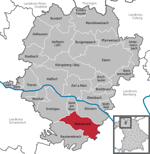
| Location of the municipality of Oberaurach in the Haßberge district | ||
  |
||

Oberaurach is a municipality in the Haßberge district in Lower Franconia . A place called Oberaurach does not exist, the administration is in Tretzendorf.
geography
Geographical location
Oberaurach is located in the Steigerwald Nature Park . The Aurach rises to the west of the Neuschleichach district . The Knetzberge-Böhlgrund natural forest is one of the largest forest protection areas in Bavaria in the municipality .
Community structure
Oberaurach is divided into eleven districts (population in brackets):
|
|
Neighboring communities
| municipality Knetzgau |
Municipality Sand am Main |
City of Eltmann |
.svg)
|
Community Priesendorf |
|
| Community Rauhenebrach |
Community of Schönbrunn in the Steigerwald |
history
Some parts of the community were first mentioned in documents in 741 and 753. Originally the Bishopric of Würzburg belonging place came up short for the Grand Duchy of Wurzburg of Archduke Ferdinand of Tuscany before the Treaties of Paris came to Bayern 1814th In the course of the regional reform in Bavaria , today's political municipality was created on May 1, 1978, whereby the municipality name Oberaurach was introduced as an artificial word for the municipalities on the upper course of the Aurach . The municipality of Oberaurach consists of the formerly independent municipalities of Dankenfeld, Fatschenbrunn, Kirchaich, Neuschleichach, Oberschleichach, Tretzendorf, Trossenfurt and Unterschleichach.
Ecclesiastically, the districts of Kirchaich and Dankenfeld belong to the Archdiocese of Bamberg , the districts of Trossenfurt / Tretzendorf, Ober-, Unter- and Neuschleichach, Fatschenbrunn and Hummelmarter to the Diocese of Würzburg .
politics

mayor
Thomas Sechser (CSU) has been mayor since 2008. In 2014 he prevailed with 53.76% of the vote against Sabine Weinbeer (Free Voters) and Thomas Karg (SPD), against whom he had already stood in 2008 and won with 55.37% of the votes. On March 15, 2020, Sechser was elected for a further six years with 78.5% of the vote. His predecessor was Siegmund Kerker (CSU).
Municipal council
City council election 2020
The municipal council has 16 members:
- CSU : 5 seats (33.77%)
- Greens : 3 seats (16.54%)
- Free voter community Oberaurach : 4 seats (25.94%)
- Young citizens of Oberaurach : 4 seats (23.75%)
City council election 2014
The municipal council has 16 members:
- CSU 6 seats
- SPD 3 seats
- Free voter community Oberaurach 4 seats
- Young citizens (close to the CSU) 3 seats
City council election 2008
The municipal council has 16 members:
- CSU 7 seats
- SPD 3 seats
- Free voter community Oberaurach 3 seats
- Young citizens (close to the CSU) 3 seats
Local council election 2002
The council had 16 members:
- CSU 6 seats
- SPD 4 seats
- Free voter community Oberaurach 3 seats
- Young citizens (close to the CSU) 3 seats
coat of arms
The description reads: Above a black corrugated shield base, inside a silver fish, in silver between two inclined red beech leaves a fallen, shortened, curly black tip, inside a golden unicorn trunk.
The unicorn is the diminished coat of arms of the former knight canton of Steigerwald and, together with the beech leaves, indicates the geographical location of the municipality in the northern Steigerwald. The base of the wave shield represents the Aurach, while the fish indicates the fish farming in the Aurachgrund. The colors silver and black are taken from the coat of arms of the Marschalken von Ostheim , who came into the possession of the Dankenfeld castle estate in 1663/64. The colors black and gold as well as silver and red are the colors of the Hochstifte Bamberg and Würzburg , which both ruled the municipality.
Architectural monuments


traffic
Oberaurach is close to the A 70 motorway (junction 11 Knetzgau ) and directly on the Steigerwald-Höhenstraße .
Personalities

- Armin Knab (1881–1951), German composer, musician and lawyer, born in Oberaurach OT Neuschleichach.
Web links
- Entry on the coat of arms of Oberaurach in the database of the House of Bavarian History
Individual evidence
- ↑ "Data 2" sheet, Statistical Report A1200C 202041 Population of the municipalities, districts and administrative districts 1st quarter 2020 (population based on the 2011 census) ( help ).
- ↑ http://www.bayerische-landesbibliothek-online.de/orte/ortssuche_action.html ? Anzeige=voll&modus=automat&tempus=+20111025/124357&attr=OBJ&val= 1634
- ^ Federal Statistical Office (ed.): Historical municipality directory for the Federal Republic of Germany. Name, border and key number changes in municipalities, counties and administrative districts from May 27, 1970 to December 31, 1982 . W. Kohlhammer GmbH, Stuttgart / Mainz 1983, ISBN 3-17-003263-1 , p. 760 .
- ↑ Results of the 2020 municipal council election , accessed on June 25, 2020
- ↑ https://www.hdbg.eu/gemeinden/web/index.php/detail?rschl=9674159

Aidhausen | Breitbrunn | Bundorf | Burgpreppach | Ebelsbach | Boars | Eltmann | Ermershausen | Gädheim | Hassfurt | Hofheim in Lower Franconia | Kirchlauter | Knetzgau | Königsberg in Bavaria | Maroldsweisach | Oberaurach | Pfarrweisach | Rauhenebrach | Rentweinsdorf | Riedbach | Sand am Main | Stettfeld | Theres | Untermerzbach | Wonfurt | Zeil am Main