
Ploulec'h
| Ploulec'h | ||
|---|---|---|
|
||
| region | Brittany | |
| Department | Cotes-d'Armor | |
| Arrondissement | Lannion | |
| Canton | Lannion | |
| Community association | Lannion-Trégor Communauté | |
| Coordinates | 48 ° 43 ′ N , 3 ° 30 ′ W | |
| height | 0-112 m | |
| surface | 10.15 km 2 | |
| Residents | 1,636 (January 1, 2017) | |
| Population density | 161 inhabitants / km 2 | |
| Post Code | 22300 | |
| INSEE code | 22224 | |
| Website | http://mairie.pagespro-orange.fr/communeploulech | |
 Town hall of Ploulec'h |
||

Ploulec'h ( Breton : Ploulec'h ) is a French municipality with 1636 inhabitants (as of January 1 2017) in Côtes-d'Armor in the region of Brittany . The municipality belongs to the Arrondissement of Lannion and the Canton of Lannion . The inhabitants are called Ploulec'hois .
geography
Ploulec'h is located about 58 kilometers west-north-west of Saint-Brieuc on the Léguer estuary . Ploulec'h is surrounded by the neighboring communities of Lannion in the north and east, Ploubezre in the east and southeast and Ploumilliau in the south and west.
Population development
| year | 1962 | 1968 | 1975 | 1982 | 1990 | 1999 | 2006 | 2013 |
| Residents | 677 | 673 | 853 | 1,229 | 1,404 | 1,466 | 1,620 | 1,671 |
| Source: Cassini and INSEE | ||||||||
Attractions
See also: List of Monuments historiques in Ploulec'h
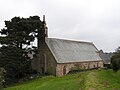
- Saint-Dogmaël Church
- Notre-Dame chapel in Yaudet
- Gallo-Roman oppidum Yaudet
- Kerninon Castle, built at the end of the 18th century
Notre-Dame chapel

Saint-Dogmaël Church

_%C3%89glise_01.JPG)
Community partnerships
There is a partnership with the British parish of St Erth in the county of Cornwall (England).
literature
- Le Patrimoine des Communes des Côtes-d'Armor. Flohic Editions, Volume 1, Paris 1998, ISBN 2-84234-017-5 , pp. 548-550.
Web links
Commons : Ploulec'h - collection of images, videos and audio files