
Poros (island)
|
Municipality of Poros Δήμος Πόρου (Πόρος) |
|||
|---|---|---|---|
|
|||
| Basic data | |||
| State : |
|
||
| Region : | Attica | ||
| Regional District : | Islands | ||
| Geographic coordinates : | 37 ° 31 ' N , 23 ° 29' E | ||
| Area : | 22.9 km² | ||
| Residents : | 3,993 (2011) | ||
| Population density : | 174.4 inhabitants / km² | ||
| Community logo: |
 |
||
| Seat: | Porous | ||
| LAU-1 code no .: | 5206 | ||
| Districts : | no | ||
| Local self-government : | no | ||
| Website: | www.poros.gr | ||
| Location in the Attica region | |||
 |
|||

Poros ( Greek Πόρος ( m. Sg. )) Is a small Greek island in the Saronic Gulf northeast of the Peloponnese .
At the same time it forms a community ( Greek δήμος , Dimos ) in the Attic regional district islands .
description
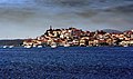
The island of Poros is removed from the Peloponnesian coast near Galatas by a 300 meter wide canal . The larger northern part of the island Kalavria (Καλαυρία) is connected by an isthmus ( isthmus ) with the smaller southern Sferia (Σφαιρία), which is of volcanic origin. Characteristic of the northern part of the island is a dense vegetation with Aleppo pines that reach down to the coast. The island is a good 23 square kilometers and has around 4,000 inhabitants, who are concentrated in the main town of Poros . This extends from the west side of Sferia to over the isthmus.
In the north and northeast, olives and citrus trees are grown and fish are farmed, and wine thrives on the Fousas plateau . In addition, the tourist infrastructure is well developed.
geology
Sferia is of volcanic origin and belongs to the volcanoes of the Saronic Gulf ( Aegina , Methana and Krommyonia ) (geologically considered active ). Geologically, the Poros volcano is located on the Epidaurus Rift, a heavily tectonically stressed zone that extends from south to north on the east coast of the Peloponnese. The strait between Galatas and Poros is one of them and has been sinking since ancient times. Pausanias says that he still waded through the swamp that lay between the two places and is now up to four meters deep in the sea. Subsidence and uplift continue and future volcanic eruptions are to be expected especially in the region around Methana.
Attractions
Many old houses have been preserved on Poros, which also give the main town its picturesque appearance. The island is a popular destination for Athenians and can be easily reached by regular ferries and hydrofoils from Piraeus .
The small archaeological museum of the island is worth seeing, in which finds from the ancient Troizen , from the Mycenaean Acropolis at Galatas and finds from the Mycenaean sanctuary of Methana are exhibited. The ancient name of Poros was Pogon ( Greek ΠΟΓΟΝ ). For some time, experts have been talking about the fact that the tomb of the mythical hero Theseus could have been on the Magoula hill near Galatas .
The foundations of a temple of Poseidon are on Kalavria . The Zoodochos Pigis monastery (= life-giving spring ) is also located on Kalavria .

Aerial view

Poros seen from the mainland

Poros, old town with clock tower

Clock tower over Poros
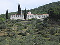
Zoodochos Pigis Monastery
Porous
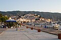
Poros, port with old town
.png)


Sons and daughters
- Alexandros Koryzis (1885–1941), Greek politician
- Minos Kyriakou (1938-2017), Greek manager
Individual evidence
- ↑ Results of the 2011 census at the Greek Statistical Office ELSTAT ( Memento of the original from November 13, 2011 in the Internet Archive ) Info: The archive link has been inserted automatically and has not yet been checked. Please check the original and archive link according to the instructions and then remove this notice.
- ↑ Poros is next to the named after a saint island of Agios Efstratios the only inhabited ending in "_os" island, which grammatically masculine gender is, all others are feminine. So the Poros, but the Rhodos, the Kos etc. The masculine Greek word poros means “ford”.
- ↑ Kalavria means light breeze
- ↑ Arne Strid & Kit Tan (Eds.) 1997: Flora Hellenica, vol. 1. Gymnospermae to Caryophyllaceae. - Königstein: Koeltz Scientific Books, xxxvi + 547 S, incl. 722 distribution maps (map 9).