
Romny
| Romny | |||
| Ромни | |||

|
|
||
| Basic data | |||
|---|---|---|---|
| Oblast : | Sumy Oblast | ||
| Rajon : | District-free city | ||
| Height : | 171 m | ||
| Area : | 29 km² | ||
| Residents : | 40,681 (2016) | ||
| Population density : | 1,403 inhabitants per km² | ||
| Postcodes : | 42000 | ||
| Area code : | +380 5448 | ||
| Geographic location : | 50 ° 45 ′ N , 33 ° 29 ′ E | ||
| KOATUU : | 5924100000 | ||
| Administrative structure : | 1 city, 2 villages, 1 settlement | ||
| Mayor : | Viktor Perewarucha | ||
| Address: | бул. Свободи, буд. 1 42000 м. Ромни |
||
| Website : | City Council website | ||
| Statistical information | |||
|
|||


Romny ( Ukrainian Ромни ; Russian Ромны ) is a city in Sumy Oblast in northeast Ukraine . Romny is the center of the Rajons of the same name and has 40,000 inhabitants (2016).
geography
The city is located 105 km west of the Sumy Oblast center on the bank of the Sula River , a tributary of the Dnieper into which the Romen River flows. The city also includes the settlement Lutschky (Ukrainian Лучки , 438 inhabitants) and the villages Kolisnykowe (Ukrainian Колісникове , 43 inhabitants) and Hrabyne (Ukrainian Грабине ).
history
Romny was first mentioned in 1096 . In 1638 6,000 inhabitants lived in the city, making it the largest settlement in the wide area. In 1781 she was granted city rights by the Russian Tsarina Catherine the Great . After the population had increased from 52,529 to 57,051 between 1979 and 1989, it has fallen by more than 10% since then.
Economy and Transport
Romny is located on the regional road P-01 ( Kiev - Pryluky - Romny - Sumy - Kursk ) and on the railway line Homel - Bachmatsch - Romodan - Kremenchuk .
Population development
| 1897 | 1923 | 1926 | 1939 | 1959 | 1970 | 1979 | 1989 | 2001 | 2010 | 2016 |
|---|---|---|---|---|---|---|---|---|---|---|
| 22,510 | 24.205 | 25.174 | 25,962 | 40,027 | 48.040 | 52,529 | 57.051 | 50,448 | 44,429 | 40,681 |
Source:
sons and daughters of the town
- Chaim Arlosoroff (1899–1933), Zionist politician
- Borys Antonenko-Dawydowytsch (1899–1984), Ukrainian writer, translator and linguist
- Abram Joffe (1880–1960), physicist
- Dawid Kritschewski (1894–1942), Ukrainian-Russian architect
- Tetjana Markus (1921–1943), Ukrainian resistance fighter against National Socialism
- Petro Redkin (1808–1891), Ukrainian-Russian lawyer, historian of philosophy, professor and university rector
- Isaak Schwarz (1923–2009), composer (including film music)
- Grigory Sokolnikow (1888–1939), Soviet politician
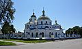
Church of the Ascension in Romny

Previous seminar
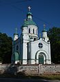
All Saints Church in Romny

Historic hospital
_(YDS_6646).JPG)
.JPG)
.JPG)
.JPG)
Web links
- Romny . In: Filip Sulimierski, Władysław Walewski (eds.): Słownik geograficzny Królestwa Polskiego i innych krajów słowiańskich . tape 9 : Poźajście – Ruksze . Walewskiego, Warsaw 1888, p. 736 (Polish, edu.pl ).
- A page about Romny (Ukrainian)
Individual evidence
- ↑ a b c Population figures on pop-stat.mashke.org
Bilopillja | Buryn | Druzhba | Hluchiw | Konotop | Krolevets | Lebedyn | Ochtyrka | Putywl | Romny | Shostka | Seredyna-Buda | Sumy | Trostyanets | Worozhba
Urban-type settlements
Chotin |
Dubovyazivka |
Esman |
Jampil |
Kyrykivka |
Krasnopillja |
Lypowa Dolyna |
Mykolaivka |
Nedryhajliw |
Nysy |
Shalyhyne |
Snob Nowhorodske |
Stepanivka |
Swessa |
Terny |
Chupachivka |
Uhrojidy |
Ulyanivka |
Welyka Pyssariwka |
Voronian
