Püdensdorf Castle

The lost Püdensdorf Castle was located in the Chammünster district of the Upper Palatinate town of Cham in the Cham district of Bavaria .
history
The original Niederungsburg Püdensdorf was a castle in the fortification ring around Castle Cham ; similar to Castle Chameregg , Katzberg or Satzdorf and served Püdensdorf in the south of Cham as the last preliminary work of this fortification. Since the facility was in the flood area of the Regen and the Chamb , it can be assumed that it was a water castle. The 12th century is assumed to be the date of origin. Holders are likely to Püdensdorfer , Ministeriale the Marquis of Cham , have been.
The first document of this family is likely to be Aerbo de Pudemingesdorf , who appears as a witness in a handover of goods to the Reichenbach monastery . In 1290 and 1294, Syfridus, Pertoldus et Fredericus fratres de Pvedmenstorf are named in connection with a donation to the Schönthal monastery as fiefs of the Bavarian Duke Otto II . A Syfridus miles from Pudminstorf is mentioned again in 1300 as a witness. Until the 16th century, the Püdensdorfer are proven here as owners. In 1379 Ulrich Püdensdorfer appeared as judge at Wetterfeld Castle ; In 1437 his descendant of the same name, who also fought against the Hussites in the Battle of Hiltersried in 1433 , is named as the keeper of Neunburg vorm Wald . Under Leonhard Püdensdorfer the status of Hofmark was first documented in 1488 . On April 1, 1528, Michael Püdensdorfer , at times a district judge in Cham, had to sell the headquarters to Christoph Otinger, the Neunburger Landschreiber and Chamer Kastner , due to a financial emergency .
From 1529 on, Christoph Oettinger is the master of Püdensorf. In 1540 he was succeeded by Hans Wenstl von Windischbergerdorf . The property passed through his daughter to the dean of Cham, Oswald Ruland . This is said to have made extensions. He was succeeded by his son Hilarius Ruland in 1477 , who passed the property on to his stepson Johann Walter Helberger in 1583 and who in turn sold it to his son Johann Ulrich in 1603. He sells the country estate to Hans Fuchs on Arnschwang . In 1609 another Püdensorfer is resident here; but he sold the estate back to the fox in 1612 . In 1615 Hans Wilhelm Fuchs exchanged the estate with the widow Sibylla Elisabetha of the late Ludwig von Eyb for the Hofmark Ränkam . Wolf Georg von Schönstein is certified here in 1618 . From 1630 the Poißl von Loifling are attested as owners. In 1663 they were followed by Josef Simon von Preu and in 1689 by the Gleißenthaler on Zandt . In 1710 the Barons von Vieregg acquired the country estate and stayed here until the 19th century. In 1829 the citizens of Cham, the so-called "Püdensdorfer Weidengemeinschaft", bought the over-indebted estate from the last surviving Vieregger daughters.

Püdensdorf Castle used to be
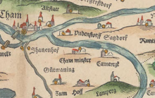
The location of Püdensdorf at the meeting of the Regen and Chamb rivers can be seen very well on Philipp Apian's land boards from 1568. The castle was located in a slightly swampy area directly on the left bank of the Regen, approx. 1500 m east of Cham and approx. 1000 m northwest of Chammünster. You can see a two-storey gable roof building with a large tower attached to the side.
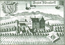
Based on the engraving by Michael Wening from 1721, Püdensdorf Castle is a two-story, angled complex with a curved baroque facade. The castle is represented as a moated castle. Further components, including a gable roof tower, are in the palace area.
The castle was damaged in 1806 when the rain poured directly past it. After a gable collapsed in 1826 as a result of a storm, another ice rush that destroyed the surrounding wall caused half of the building to collapse in 1829, so that it was subsequently completely dismantled and leveled while the demolition material was sold. The associated properties have been sold. For a long time after the demolition, the location of the former castle building was only marked by a slight elevation in the meadow area directly on the rain bank. It was not until 2003 that a memorial stone was erected at this point on the initiative of the old town friends of Cham and with the support of the Lions Club Cham, and a pear tree was planted again, the lost predecessor of which was the only memory of the castle.
literature
- Max Piendl: The Cham district court (p. 57). (= Historical Atlas of Bavaria, part of Altbayern booklet 8). Commission for Bavarian History, Michael Lassleben Verlag, Munich 1955.
Web links
Coordinates: 49 ° 12 '36.7 " N , 12 ° 41' 58.2" E

