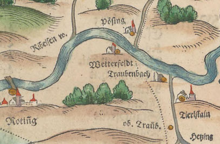
Untertraubbach Castle

The lost Untertraubbach Castle was located in the district of the same name in the Upper Palatinate town of Cham in the Cham district of Bavaria .
history
The name Untertraubbach is derived from the Traubenbach , which flows into the rain here . The brook was first mentioned in 1003 as Drubinaha , when King Heinrich II donated the Hötzing estate to the Freising diocese . Drubinaha means dark, cloudy water, which was caused by the alder and willow bushes.
The first landlords in Traubenbach were the abbesses of the aristocratic Obermünster convent in Regensburg . The monastery courtyard with a small chapel was located in the Angerl district , which is still called that today. The Amtshof was also known as a skyscraper and was used as a retirement home and poor house in the 19th century. It burned down in 1894 and the old village cemetery was built in its place.
The history of Thierlstein and Traubenbach Castle (today Untertraubbach) show a close relationship. Around 1180, a Mengotus de Trübinbach renounced the Reichenbach monastery on an estate of his brother Gozpert , which the latter had donated in Trübinbach. The Trübenbacher and the Thierlinger seem to have been related to each other. The Thierlingers should have inherited the inheritance . In 1441 Stephan Thierlinger called himself after Traubenbach. Stefan the Türlinger zum Türlstein is mentioned in 1428 and therefore Thierlstein Castle is certified as the ancestral seat of this family.
In the land table from 1488, both castles are mentioned as having different owners, but only Thierlstein is owned by the Thierlingers and Traubenbach is owned by the Murachers . In 1503 both court stamps are again shown as belonging to the Thierlingers , although Traubenbach is still shown to the Murachers. At the end of the 16th century, a daughter of Georg von Murach finally brought Traubenbach into marriage with Georg Thierlinger . Since then, both court brands have been linked in personal union or Trübenbach is an incorporated Hofmark von Thierlstein.
The Trübenbacher (also called Drubenbecker ) are considered to be the founders of the local castle. They were the founders of the outer village and built a castle for themselves, on the foundation walls of which stands today's church of St. Martin. On the map of Philipp Apian from 1588, a castle-like building with a gable roof can be seen in Traubenbach . The castle and parish church were destroyed during the Thirty Years War , after which the parish church was rebuilt on the site of the destroyed castle. According to the year on the west side of the church, this is said to have been 1719. Archaeological findings in the area of the abandoned castle of Untertraubbach are still preserved as a ground monument of the previously medieval castle.
literature
- Max Piendl: The Cham district court (pp. 48–49). (= Historical Atlas of Bavaria, part of Altbayern booklet 8). Commission for Bavarian History, Michael Laßleben Verlag , Munich 1955.
Individual evidence
Web links
Coordinates: 49 ° 12 ′ 46.1 ″ N , 12 ° 34 ′ 48.6 ″ E

