St. Eustatius
| Sint Eustatius Special parish of the Netherlands |
|||||
|
|||||
| Official language | Dutch , English , ( Papiamentu ) | ||||
| Capital | Oranjestad | ||||
| Form of government | Parliamentary monarchy | ||||
| Government system | Special municipality of the Netherlands | ||||
| Head of state | King Willem-Alexander | ||||
| Head of government | Gezaghebber Julian Woodley | ||||
| surface | 21 km² | ||||
| population | 3193 (December 2015) | ||||
| Population density | 152 inhabitants per km² | ||||
| currency | US dollar (USD) | ||||
| founding | October 10, 2010, through the dissolution of the Netherlands Antilles | ||||
| Time zone | UTC − 4 | ||||
| License Plate | NL ; Region code E | ||||
| ISO 3166 | BQ-SE , NL-BQ3 | ||||
| Internet TLD | .an (until July 31, 2015), .bq (currently not used), .nl | ||||
| Telephone code | + 599-3 | ||||
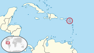
Sint Eustatius ( Dutch , in German outdated St. Eustaz ) is one of the three Dutch BES islands in the Caribbean and had around 3200 inhabitants in 2016. The island is a special municipality in the Netherlands.
geography
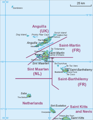
The neighboring islands are St. Kitts in the south-east , Saint-Barthélemy and St. Martin in the north and Saba in the north-west .
Like Saba and St. Martin, Sint Eustatius belongs to the islands over the wind , more precisely to their northern part, known in English as the Leeward Islands . It is one of the SSS islands , has a land area of 21 km² and is the second smallest of the five inhabited islands of the former Netherlands Antilles after Saba . The capital of Sint Eustatius is Oranjestad (not to be confused with Oranjestad in Aruba ).
Map with all coordinates: OSM | WikiMap![]()
| Geozone | Area km² |
Population 2001 |
Coordinates |
|---|---|---|---|
| Oranjestad | ... | 513 | 17 ° 29 ′ 0 ″ N , 62 ° 59 ′ 0 ″ W. |
| Golden Rock / Concordia | ... | 525 | ... |
| Jeems | ... | 118 | ... |
| Wilton Farm / Union | ... | 422 | ... |
| Mansion | ... | 71 | ... |
| Princess Garden | ... | 153 | ... |
| Chapel piece | ... | 56 | ... |
| Cherry tree | ... | 152 | ... |
| Bay Brown | ... | 110 | ... |
| Mountain | ... | 65 | ... |
| not assigned | ... | 107 | ... |
| St. Eustatius | 21st | 2292 | 17 ° 29 ′ 7 ″ N , 62 ° 58 ′ 23 ″ W. |
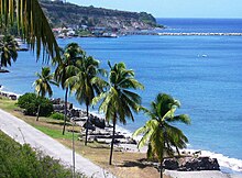
On Sint Eustatius itself there is a dormant stratovolcano in the southeast with the 600 m high The Quill , whose crater is a tourist attraction. In the northwest there is a group of less high hills around Boven Mountain . Most of the island's population lives in the valley between the two elevations. The capital Oranjestad, located south of the airport, had around 1,100 inhabitants in 2004. The second town on the island, Concordia, is north of Oranjestad near the airport. There are other places on a tourist map: Fort de Windt on the southern tip of the island and Golden Rock between Oranjestad and Concordia.
climate
Sint Eustatius has a tropical climate with correspondingly warm temperatures and less pronounced seasons. In the first half of the year there is usually much less rain than in the rest of the year. From August to October strong winds up to hurricane strength can occur.
|
Climate diagram for Sint Eustatius
Source: www.msn.com
|
|||||||||||||||||||||||||||||||||||||||||||||||||||||||||||||||||||||||||||||||||||||||||||||||||||||||||||||||||||||||||||||||||||||||||||||||||||||||||||||||||||||
population
In the 18th century, when the island reached its economic height, more than 8,000 regular residents lived on Sint Eustatius; together with the temporarily present traders and ship crews, up to 20,000 people are likely to have populated the island at times. In the 2001 census, there were 2,292 people in Sint Eustatius, which corresponded to a population density of 109 inhabitants / km². At the end of 2007 the island had around 3300 inhabitants, at the end of 2013 it was more than 4000, but two years later only just under 3200 inhabitants.
history
The island was named after Eustachius , a Christian saint. Locals in particular often refer to it as "Statia".
Sint Eustatius was discovered by Christopher Columbus in 1493 . In 1636, Zeeland merchants colonized the island with the permission of the Chamber of the Province of Zeeland of the Dutch West India Company . In the following period, ownership of the island changed 22 times between the Netherlands , France and England or Great Britain , before the Netherlands finally gained sovereignty over Sint Eustatius in 1816.
From 1682, the colony, which had meanwhile benefited from trade and from sugar, tobacco and cotton cultivation, also administered the neighboring areas of Saba and (from 1703) Sint Maarten .
In 1739 one of the first Jewish communities in America was founded here with the Honin Dalim Synagogue.
In the 18th century, the island became wealthy by supplying weapons and ammunition, among other things, to any state willing to pay for them across trade embargoes. The Thirteen Colonies in particular benefited from this, as they were able to obtain weapons for their rebellion against Great Britain in this way .
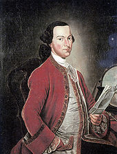
These good relationships with the colonies striving for independence led to a historically not insignificant event: On November 16, 1776 - on the orders of Governor Johannes de Graaff - the cannons of Fort Orange answered Andrew Doria's salute , those under the red and white stripes Flag of the Second Continental Congress sailed. This was the first time that the sovereignty of the United States was recognized by a foreign power (read from Barbara Tuchman : “ The First Salute” ).
As much as this trade relationship brought economic progress, it was also one of the main reasons for the Fourth Anglo-Dutch Sea War , which lasted from 1780 to 1784 and was a disaster for Dutch trade. In the course of this naval war, the British took over Sint Eustatius on February 3, 1781 from the Dutch commander Johannes de Graaff, who surrendered without a fight in view of the great superiority of British troops under General John Vaughan and Admiral George Brydges Rodney . Ten months later, France, an ally of the Netherlands, conquered the island, which returned to Dutch hands at the end of the war (1784). After further occupations by France and Great Britain, Sint Eustatius finally became a Dutch colony in 1816.
In 1954, Sint Eustatius became an eilandgebied ("island area", a kind of municipality) part of the newly founded autonomous federal state of the Netherlands Antilles .
In a referendum, Sint Eustatius decided to remain in the national association of the Netherlands Antilles, but stood alone with his vote, as all other islands were in favor of dissolution. Since then, politicians have advocated direct relations with the Netherlands. On October 11, 2006, Sint Eustatius, Saba and Bonaire reached an agreement with the Dutch government to incorporate the islands into the Netherlands as bijzondere gemeenten (“special municipalities”). On October 10, 2010, the National Association of the Netherlands Antilles was dissolved. Since that day, Sint Eustatius belongs to the Netherlands as a special parish.
The currency has been the US dollar since 2011 , which replaced the Antilles guilder as legal tender on the island. The old currency became invalid in the three special municipalities within one month.
With the dissolution of the Netherlands Antilles, its police authority, the Korps Politie Nederlandse Antilles (KPNA), was also dissolved. For the BES Islands, the Corps Politie Caribisch Nederland took its place .
language
The official language of Sint Eustatius is Dutch , and English is used as the language of communication and business in everyday life . Since 2014, English has also been the first school language on the island and Dutch is taught as a foreign language. The Creole language Papiamentu only plays a subordinate role on Sint Eustatius compared to the rest of the Dutch Caribbean .
National parks
There are two national parks on Sint Eustatius .
economy
In the 18th century the island was probably the most important trading center of the Netherlands in the Caribbean. At that time, it was also known as the Golden Rock because of its immense wealth . The streets were lined with numerous warehouses, most of which have now fallen into disrepair.
The shift of transatlantic trade north to the now independent United States, the decline of the slave trade and the French occupation of the island in 1795 ended the economic prosperity of St. Eustatius.
According to the government, the island's economy is in good shape and has strong growth potential for the near future.
The government is the main employer in Sint Eustatius. It is orienting its growth strategy towards tourism, especially ecotourism . The most important private actor in the economy is the company "NuStar", which operates a large tank farm on the island for the international oil trade.
transport
Air traffic
Maritime transport
The port was opened in 1993 and consists of an 80 meter long breakwater and a 60 meter long pier with a loading facility for ferries . It is designed for ships with up to 600 gross tons . All cruise ships are currently anchored off the coast and bring their passengers ashore in tender boats . The ships can refuel at the local oil terminal. Statia Terminals NV is an independent oil port located in the northwest of the island.
See also
literature
- M. John Roobol, Alan L. Smith: Volcanology of Saba and St. Eustatius, Northern Lesser Antilles . Koninklijke Nederlandse Akademie van Wetenschappen, Amsterdam 2004, ISBN 90-6984-384-6 (English, spaw-palisting.org [PDF; 7.3 MB ]).
Web links
- St. Eustatius Government. Official website of the government of St. Eustatius.
- Sint Eustatius travel. In: Lonely Planet. Travel guide with a map of the island. There are eleven pages in printed form inLonely Planet's Eastern Caribbean travel guide(p. 381 ff).
- St. Eustatius Center for Archaeological Research (SECAR). SECAR website.
Individual evidence
- ↑ Invoeringswet openbare lichamen Bonaire, Sint Eustatius en Saba (Law on Public Administration Bonaire, Saint Eustatius and Saba). Hoofdstuk 2b. De taal in het bestuurlijk verkeer (Chapter 2b. The language in administrative dealings). In: Overheid.nl. Nederlandse Ministerie van Binnenlandse Zaken en Koninkrijksrelaties, accessed on 5 November 2017 (Dutch).
- ↑ a b Caribisch Nederland; bevolkingsontwikkeling, geboorte, sterfte, migratie. In: CBS StatLine. Centraal Bureau voor de Statistiek (CBS), November 29, 2016, accessed November 5, 2017 (Dutch).
- ↑ a b How does the conversion to the US dollar work? In: Frequently asked questions. De Nederlandsche Bank - Bonaire, Sint Eustatius, Saba, archived from the original on July 20, 2011 ; accessed on November 5, 2017 .
- ↑ Internetextensie .AN as of July 31, definitely uit de lucht. In: Versgeperst.com. July 7, 2015, archived from the original on September 8, 2015 ; Retrieved November 9, 2017 (Dutch).
- ↑ Country code top-level domain. Current ccTLDs. In: ICANNWiki. Retrieved November 5, 2017 .
- ↑ Francis Vierbergen (ed.): Geo data 2001 Saba & Sint Eustatius - Socio-economic aspects placed in a spatial context . Central Bureau of Statistics, Willemstad May 2007, p. 34 , Table 17: Population by sex and sex ratio, Sint Eustatius (English, online [PDF; 1,2 MB ; accessed on November 5, 2017]).
- ↑ Map View. Map of Sint Eustatius. In: Sint Eustatius travel. Lonely Planet, accessed November 5, 2017 .
- ↑ St. Eustatius - Statia Map. Tourist map of St. Eustatius. In: statiatourism.com. St. Eustatius Tourism Development Foundation, archived from the original on August 10, 2014 ; accessed on November 5, 2017 .
- ↑ Netherlands Antilles climate. Retrieved June 27, 2018 .
- ↑ Historical weather Sint Eustatius. In: msn.com. Retrieved June 27, 2018 .
- ↑ a b c Statia’s history. In: Mazinga on the Bay. Tony and Leontine Durby, accessed April 8, 2020 .
- ↑ a b c The Golden Age - Historic period (AD 1492-20th century). In: History of St. Eustatius. St. Eustatius Center for Archaeological Research (SECAR), archived from the original on November 7, 2017 ; accessed on April 8, 2020 (English).
- ^ Han Jordaan, Victor Wilson: The Eighteenth-Century Danish, Dutch, and Swedish Free Ports in the Northeastern Caribbean - Continuity and Change . In: Gert Oostindie, Jessica V. Roitman (eds.): Dutch Atlantic Connections, 1680–1800: Linking Empires, Bridging Borders . Brill, Leiden / Boston 2014, ISBN 978-90-04-27132-6 , pp. 276 , The Historical Background of St. Eustatius, St. Thomas and St. Barthélemy , doi : 10.1163 / 9789004271319_013 (English).
- ^ History of Sint Eustatius. In: Lonely Planet Travel Information. Retrieved November 5, 2017 .
- ↑ Barbara Tuchman : The first salute . S. Fischer, Frankfurt am Main 1988, ISBN 3-10-080006-0 (American English: The First Salute - A View of the American Revolution . New York 1988. Translated by Malte Friedrich).
- ^ Carl Renatus Hausen : Historical Portfolio. To know the present and the past . First year, ninth piece; Month September 1782. Vienna / Breslau / Leipzig / Berlin / Hamburg 1782, V. Admiral Rodney's great services during the present war, p. 1112 ( full text in Google Book Search).
- ↑ English to be sole language of instruction in St Eustatian schools. government.nl, June 19, 2014, accessed on February 22, 2020 .
- ↑ Dutch in the world: The Caribbean. In: Niederlandistik.fu-berlin.de. Free University of Berlin, December 5, 2016, accessed on February 24, 2020 .
- ^ A b St. Eustatius Government - Economy. St. Eustatius Government, archived from the original on November 17, 2015 ; accessed on November 5, 2017 .
- ↑ St. Eustatius. Economy. Rijksdienst Caribisch Nederland (RCN), archived from the original on October 6, 2014 ; accessed on November 6, 2019 .
- ↑ St. Eustatius. Specifications. NuStar Energy, LP, accessed November 5, 2017 .
Coordinates: 17 ° 29 ′ 7 " N , 62 ° 58 ′ 23" W.


