
Bonaire
| Bonaire Special municipality of the Netherlands |
|||||
|
|||||
| Official language | Dutch , Papiamentu | ||||
| Capital | Kralendijk | ||||
| Form of government | parliamentary monarchy | ||||
| Government system | Special municipality of the Netherlands | ||||
| Head of state | King Willem-Alexander | ||||
| Head of government | Gezaghebber Edison Rijna | ||||
| surface | 288 km² | ||||
| population | 18,413 (2014) | ||||
| Population density | 60 inhabitants per km² | ||||
| currency | US dollar (USD) | ||||
| founding | October 10, 2010, through the dissolution of the Netherlands Antilles | ||||
| National anthem | Tera di Solo y suave biento | ||||
| Time zone | UTC-4 , Atlantic Time Zone | ||||
| License Plate | NL ; Region code B | ||||
| ISO 3166 | BQ-BO, NL-BQ1 | ||||
| Internet TLD | .nl , .bq (currently not used), .an (until July 31, 2015) | ||||
| Telephone code | + 599-7 | ||||
  |
|||||
 |
|||||
.jpg) |
|||||

.svg)
The island of Bonaire [ boˈnɛːr [ə] ] is geographically part of the Lesser Antilles . Politically, it is, together with its uninhabited side island of Klein Bonaire, a special municipality in the Netherlands . It is the second largest of the ABC islands ( A ruba , B onaire, C uraçao ). The island is particularly attractive for tourists because of the underwater world. Again the “special communities” Bonaire, Sint Eustatius and Saba are summarized as “ BES (islands) ”.
The total area is 288 square kilometers, the population is about 18,000. The island's capital is Kralendijk (a degeneration of Koralendijk (German coral dike )). The oldest settlement is Rincon .
structure
The star of the flag has six points, these points represent the six Wijken (districts). The Playa district is equated with the capital Kralendijk. Due to the strong growth and the resulting expansion of residential areas, four of these areas have merged with Playa / Kralendijk. The place Rincon is about seven kilometers northwest of Kralendijk or eleven kilometers to its suburbs.
| Wijk / District | Area km² |
Population 2007 |
Population 2011 |
Population 2016 |
|---|---|---|---|---|
| Playa [Kralendijk] | ... | 1963 | 2065 | ... |
| Tera Cora (Tera Kora) | ... | 1610 | 1861 | ... |
| Nikiboko | ... | 2633 | 2932 | ... |
| Entrejol (Antriol) | ... | 3947 | 4406 | ... |
| Noord Saliña (Nort Salinja) | ... | 2378 | 2561 | ... |
| Rincon | ... | 1788 | 1841 | ... |
| Bonaire | 288 | 14319 | 15666 | 19408 |
The districts are further subdivided into 22 Buurten / Neighborhoods .
languages
The official languages are Dutch and Papiamentu . The latter is the most widely spoken language among the population (around 75% of the population).
history


The Caiquetíos, a tribe of the Arawak , were the first settlers on Bonaire. They gave the island the name Bonay ("deep land"). The first Europeans landed in 1499 under Alonso de Ojeda and Amerigo Vespucci on the ABC Islands and took them for Spain under the name islas inútiles ("useless islands"), as they found nothing useful on the islands and the island was not suitable for agriculture suited. They also called Bonaire islas de los gigantes ("Islands of the Giants") because the inhabitants were on average a head taller than the conquerors. Between 1513 and 1515 all Indians were taken to Hispaniola as slaves and Bonaire was left depopulated and deserted.
In 1526, some of the surviving aborigines were brought back where they were used to raise cattle. They were released because they cost less. The cattle had been abandoned by the Spaniards and were now and then rounded up and "thinned out". This was primarily used for leather production and, to a lesser extent, for the production of meat, from which cured meat was made with the help of salt from the natural salt pans on the southern half of the island.
It was only later that the salt itself was extracted on a large scale, as there was initially a lack of workers. A settlement by Europeans was not encouraged by Spain because the country could not offer sufficient protection against pirates.
The oldest European settlement on the island is called Rincón ("angle") and is located in the cooler north, hidden from view from the sea, between the hills where Caiquetios lived. This community consisted mainly of convicts and prisoners of war. Later the center of gravity shifted further south, but still in the northern half and at a proper distance from the dangerous sea. The village of Al Interior ("Inland") was founded by Spaniards who had been abandoned by Dutch pirates on Bonaire. The current name is Antriol.
In 1633 the Dutch took possession of the island for the first time. They needed the ABC islands not only because of their strategic location, but especially Bonaire because of the existing but hardly developed salt flats. The salt was used in Holland for the preservation of food and increasingly for the industry, especially for ceramics ( Delft ) and glass ( Leerdam ).
After Spain incorporated its salt supplier Portugal in 1580, the Dutch initially obtained their salt from Punto de Arraya on the Venezuelan coast. After the Spanish had ruined the business here in 1621 by building a fortress ("Fort Kostverloren"), they occupied the ABC islands. They were the first to expand the salt pans. The work slaves were imported from Africa. Spaniards introduced the plantation economy and felled wood staining (Brazilian wood Haematoxylon brasiletto Karst ). An extremely hard wood for wooden gears (windmills), tiller pins and medical purposes (Wayacá, Spanish Guaiacó , Guaiacum officinale ). This was almost wiped out on Bonaire by overexploitation .
During the French Revolution, the English took over Bonaire (the Netherlands was allied with France). After Napoleon's defeat, it was finally assigned to the Netherlands in the Treaty of Paris in 1816.
The Statuut voor het Koninkrijk der Nederlanden has existed in the Kingdom of the Netherlands since 1954 . The Caribbean colony, including Bonaire, became an autonomous country as the Netherlands Antilles . Bonaire formed within this structure, a eilandgebied ( "island region").
politics

2010 referendum
Due to the uncertainty about the political future, four out of five countries voted for the separation of the Netherlands Antilles . Some wanted more autonomy, while others advocated stricter integration. The referendum for Bonaire was scheduled for March 26, 2010, but was canceled in February 2010. The vote was postponed first to September and then to October. It was finally carried out on December 17, 2010 and resulted in a majority of 84% in favor of joining the Netherlands. However, since the 35% turnout was below the required 51%, the vote was declared invalid. The result was nevertheless trend-setting.
Dissolution of the Netherlands Antilles
After the dissolution of the national association of the Netherlands Antilles on October 10, 2010, the island, like Saba and Sint Eustatius , was incorporated into the Netherlands as openbaar lichaam and bijzondere gemeente (public body and special municipality) . Instead of a mayor and a municipal council - as is usual in Dutch municipalities - there is a gezaghebber and an eilandsraad (island council, with nine elected representatives). The administration is led by a bestuurscollege , an executive body to be controlled by the island council. The zaghebber , appointed by the crown for a term of office of six years, chairs both bodies .
With the dissolution of the Netherlands Antilles, its police authority, the Korps Politie Nederlandse Antilles (KPNA), was also dissolved. The Corps Politie Caribisch Nederland (KPCN) took its place on the BES Islands . The seat of the KPCN is in Kralendijk .
nature
.jpg)
The island consists of two parts, a greener, hilly northern part and a flat southern half. The main town Kralendijk is in the transition area.
In the north, the sun and wind dry out the soil less so the vegetation is denser and more species-rich. This is where human habitation is and there are abandoned plantations. The residents sometimes still manage private mini-plantations, which they call their "Knuku".


Wild donkeys and iguanas live all over the island . Most of the donkeys are now housed in the donkey reserve near the airport. The flora is determined by tree-sized column and candelabra cacti . Column cacti are arranged as goat-safe hedges to protect the landscape . The island has lost its original vegetation through deforestation. This happened particularly during the period of the French Revolution , when the English ruled the island.
The north is still green. A characteristic tree species is the Divi-Divi tree , which directs its crown like a flag towards the trade wind . The Washington-Slagbaai National Park is located in the northwestern part of the island on the grounds of the former "plantation Washington". This included the natural port of Slagbaai (slaughter bay), from where the cured meat was shipped. The south has always been a cactus desert . The natural salt lakes there were converted into salt pans. Currently, a quarter of the island's total land area is still used for salt production in the south. In this area, flamingos can be seen, which have been given a sanctuary to build their mud nests. Since this sanctuary is located in the middle of these salt flats, it is quiet and well received by the flamingos. The salt lake in the north, the Gotomeer, is part of the "Washington Nationaal Park" and is therefore protected. Flamingos are also native to this salt water.
The coast on the east side of the island facing the ever-blowing north-east trade wind is rugged and rocky and is hit by a rough sea. There are some sandy bays in between. The largest bay is Lac with a mangrove forest. In the past centuries, it was here that large sea snails (Carcós) were caught, which was forbidden in modern times, and their shells are still lying in large quantities on the shore.
Bonaire Marine Park
In 1979, the Bonaire Marine Park was established with the aim of protecting the area's marine life. In 1999 the government officially declared it a national park. The intact reefs and clear water attract around 50,000 tourists for diving and snorkeling every year. Bonaire was voted fourth in the world's best diving spots by Forbes Traveler in 2007. In order not to endanger this paradise, strict rules for the protection of the underwater world were introduced below.
Almost all of the dive sites on the main island can be reached from the beach. Boat transport is only necessary for special dive sites on the island of Klein-Bonaire. Dive sites are marked with yellow stones on the roadside. Special dive sites on Bonaire are, for example, the 1000 Steps in the north and Angel City in the south , including the wreck of the Hilma Hooker .
The uninhabited small island of Klein Bonaire lies off the west coast . In February 1997, diving pioneer Hans Hass successfully wrote an open letter to the Bonaire authorities when the question of opening a hotel on Klein Bonaire was discussed. The project was then dropped.
economy
tourism
Tourism is mainly geared towards divers and the island is one of the best diving regions in the world. Few sandy beaches and a coral landscape encompassing the island prevent bathing tourists. Bonaire is a popular travel destination for snorkelers and windsurfers . Tourism is possible all year round and focuses on resorts that mostly have their own dive center. In addition, some are bed-and-breakfast - pensions available.
currency
The currency has been the US dollar since January 1, 2011 , which replaced the Dutch-Antilles guilder as legal tender on the island. With the changeover, the old currency became invalid within a month on the three islands of Bonaire, Saba and Sint Eustatius (BES).
traffic

.jpg)
The island's first airport was built in 1936. After US soldiers landed on Bonaire, it was found that the airport did not meet the criteria of the armed forces. Therefore, on the command of the commander, a new airport was expanded in December 1943 and opened in 1945 with a terminal. It was used until the 1980s, since then it has been modernized in sections.
The Dutch airline KLM uses Bonaire Airport three times a week for stopovers on flights to and from South America. Since the November 2011 winter flight schedule, KLM has also served daily direct flights to Bonaire from Amsterdam. The airport is equipped with a hangar, a terminal. The existing airport fire brigade has been modernized since the end of 2014.
In 2008, the operating company presented a 15-year plan for the modernization and future planning of the airport. The island's government approved it in 2009 and the first phase of this plan, runway modernization, was completed in 2011. The second phase provides for the construction of the new tower and the construction of two new taxiways. In the third phase, the terminal is to be renewed.
Localities
The only settlements with city status are Kralendijk (the capital) and Rincon .
Kralendijk has many suburbs that cannot be clearly delimited, some of which are listed, as well as smaller towns on the island.
| some suburbs of Kralendijks | smaller towns | |
|---|---|---|
|
|
|
media
Trans World Radio relay station
Trans World Radio operates a relay station on Bonaire that broadcasts on medium wave . The station's medium wave transmitter is the most powerful medium wave transmitter on the American continent. It uses four 231.6 m high transmission masts arranged in a square as a transmitting antenna and is operated at 800 kHz with 500 kW or 100 kW. The location is at 12 ° 6'23 "N 68 ° 17'1" W.
Radio Nederland Wereldomroep relay station
Radio Nederland Wereldomroep (RNW) operated a shortwave relay at 12 ° 12'48 "N 68 ° 19'23" W until 2012. The broadcasts on shortwave could also be received frequently in Europe, until RNW decided to end its shortwave broadcasts and thus also to close and tear down the broadcasting station on Bonaire.
Picture gallery
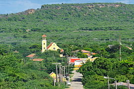
Church in Rincon
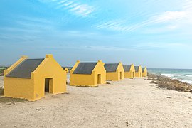
Slave houses on the southwest coast of Bonaire
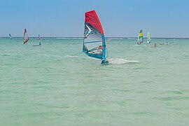
Bonaire is a windsurfing mecca
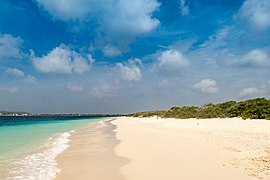
Beach on the offshore island of Klein Bonaire

Washington Slagbaai National Park on Bonaire

Aerial view of Klein Bonaire

.jpg)
.jpg)
.jpg)

.jpg)
Web links
- openbaar lichaam Bonaire official website Bonaire (Dutch, Papiamentu)
- Bonaire Tourist Board website (English, Dutch, Spanish)
- Private page with a lot of information (English)
- www.tauchimpressionen.de Recordings from the underwater world of Bonaire
Individual evidence
- ↑ Wetten.nl - Regeling - Invoeringswet openbare lichamen Bonaire, Sint Eustatius en Saba - BWBR0028063. In: overheid.nl. Wetten.overheid.nl, accessed on November 29, 2016 .
- ↑ Caribischnetwerk Gouverneur, accessed March 2015
- ↑ Statistical Office of the Netherlands. Accessed March 2015
- ↑ Money in the world
- ↑ Database on top-level domains, accessed June 29, 2016
- ↑ Internet extension .AN as of July 31st uit de lucht - Versgeperst.com Curacao. In: Versgeperst.com Curacao. July 7, 2015, accessed June 29, 2016 (Dutch).
- ^ WHO statistics . Retrieved April 7, 2020.
- ↑ Meredith Daantje-Cecilia and Frank van der Linden: Bevolkingssamenstelling in wijken op Bonaire, toen en nu
- ^ Rijksdienst Caribisch Nederland ( Memento from August 8, 2014 in the Internet Archive )
- ↑ Wetten.nl - Regeling - Invoeringswet openbare lichamen Bonaire, Sint Eustatius en Saba - BWBR0028063. In: overheid.nl. Wetten.overheid.nl, accessed on November 29, 2016 .
- ↑ The Portuguese word brasil means "glowing red" and gave the country Brazil its name.
- ^ Dissolution of the Netherlands Antilles, accessed March 2015
- ↑ The Referendum that wasn't - Bonaire Reporter, December 31, 2010, last accessed June 1, 2016.
- ^ Bonaire National Marine Park - EXECUTIVE SUMMARY. Retrieved June 20, 2018 .
- ↑ Anna Vander Broek: World's 10 best scuba spots . In: Forbes Traveler , August 2007.
- ↑ Download of the open letter from Hans Hass: Archive link ( Memento of the original from November 17, 2015 in the Internet Archive ) Info: The archive link was inserted automatically and not yet checked. Please check the original and archive link according to the instructions and then remove this notice.
- ↑ Anna Vander Broek: World's 10 best scuba spots . In: Forbes Traveler , August 2007.
- ↑ De Nederlandsche Bank - Bonaire, Sint Eustatius, Saba ( Memento of the original of December 25, 2010 in the Internet Archive ) Info: The archive link has been inserted automatically and has not yet been checked. Please check the original and archive link according to the instructions and then remove this notice. (Dutch, accessed January 1, 2011)
- ^ History of the airport, accessed March 2015
- ↑ Airlines at the airport, accessed March 2015
- ↑ Expansion plan for the airport, accessed March 2015
Aruba • Curaçao • Netherlands (with the special municipalities ) • Sint Maarten

Member States of the United Nations
Antigua and Barbuda |
Bahamas |
Barbados |
Belize |
Costa Rica |
Dominica |
Dominican Republic |
El Salvador |
Grenada |
Guatemala |
Haiti |
Honduras |
Jamaica |
Canada |
Cuba |
Mexico |
Nicaragua |
Panama |
St. Kitts and Nevis |
St. Lucia |
St. Vincent and the Grenadines |
Trinidad and Tobago 1 |
United States
Dependent Territories
US Virgin Islands |
Anguilla |
Aruba 1 |
Bermuda |
Bonaire 1 , Saba and Sint Eustatius |
British Virgin Islands |
Curacao 1 |
Greenland |
Guadeloupe |
Cayman Islands |
Martinique |
Montserrat |
Navassa |
Puerto Rico |
San Andrés and Providencia |
Saint Barthélemy |
Saint-Martin |
Saint-Pierre and Miquelon |
Sint Maarten |
Turks and Caicos Islands
1 is on the South American continental shelf, but is politically part of North America.
Coordinates: 12 ° 11 ′ N , 68 ° 15 ′ W