
Trans-Saharan Belt

In the regional geology of Africa, the Transsahara Belt represents a system of neoproterozoic folds and thrust orogens with a length of more than 3000 kilometers (km for short). It begins in the Moroccan Anti-Atlas and extends to the south Atlantic coast of Benin .
The geological development began with the formation of rifts and the opening of the oceans . The Pharusian Ocean, also known as the Transsahara Ocean, spread out between the eastern edge of the West Africa craton and the western flank of the Sahara metacraton. Another, unnamed ocean of unknown extent formed on the northern edge of the West Africa craton in front of an as yet undefined land mass (sometimes referred to as the Morocco continent). Subsequent subduction from oceanic to continental lithospheric plates resulted in new, different crustal blocks such as igneous island arcs and forearc and backarc basins . The progressive narrowing and closing of the oceans led to collisions and partial thrusts on the continental margins with orogenic folding of the crustal units, development of igneous plutons and volcanoes as well as volcanic-sedimentary deposits. Today, large belt areas are hidden under sedimentary layers of the Sahara , the Sahel and other areas.
The main phase of development falls during the Pan-African Orogeny and ranges from around 800 to 550 million years ago (abbreviated mya ).
Location and extent

The Trans-Saharan Belt emerges in Morocco , Algeria , Mali , Niger , Nigeria , Benin , Togo and Ghana . Except for Nigeria, Benin, Togo and Ghana, the belt crosses the Sahara with a length of approx. 1800 km , from which it got its name.
The Transsahara Belt is subdivided into the south-west / north-east running ( trending ) anti-Atlas belt, the quasi north-south oriented Pharuside Belt, which extends from Algeria to Mali and the subsequent southern section in Mali and Niger , which bears the name Dahomeyide Belt (Dahomeyide Belt). Its outcrops occur in the west of Nigeria, in the east of Ghana, in Togo and in Benin, where it emerges on the Gulf of Guinea with the Bay of Benin and expires in the South Atlantic .
Geologically and geomorphologically , the anti-Atlas belt is part of the atlas to the north and east . The Pharusian Belt developed between the northeast flank of the West Africa Craton and the Tuareg Shield, while the Dahomeyide Belt is bounded by the southeast edge of the West Africa Craton and the western zone of the Togo-Benin-Nigeria Shield. The latter belt thus separate the West Africa craton and the Sahara metacraton.
Although the Dahomeyide Belt is currently running out to the coast of the Atlantic Ocean, its continuation can be traced in the Borborema Province of the state of Paraíba in northeastern Brazil . The separation of these two orogen sections occurred during the opening of the South Atlantic in the early Cretaceous from 140 mya.
General geodynamic development

Schematic representation of a continental block with different old basement complexes and their sedimentary overburden
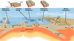
Schematic representation of essential processes along plate boundaries

Schematic representation of a rift valley in a continental plate

Schematic representation of converging lithospheric plates with subduction and fold mountains above the collision zone
Schematic representation of a subduction zone with the geological processes taking place in it

Schematic representation of a subduction zone with back arc spreading

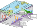
Schematic representation of an accretion wedge

Thrust system with cliff , thrust cover and window

Stages of the Wilson cycle using the example of recent processes in plate tectonics


The Transsahara Belt is based predominantly on pre-Neoproterozoic basement , which was regionally heavily revised by Neoproterozoic pan-African events and other metamorphic crust accumulations.
The geological evolution of the Trans-Saharan Belt can be traced back to the development phases of the supercontinent Rodinia . In addition to the unification of cratons and other land masses, these were also accompanied by rift fractures , which often expanded into ocean basins . In the context treated here, it was the Pharusian Ocean that separated the West Africa craton from the Sahara metacraton, as well as an as yet undefined ocean on the northern flank of the West Africa craton.
In the further plate tectonic development the movements of the lithospheric plates inverted from diverging to converging, which u. a. the subduction of oceanic crust led. As a result, new crust formations and components developed, such as backarc and forearc basins , juvenile ocean floors as a result of backarc basin spreading, igneous island arch suites, accretion wedges and sediments of different petrogenesis. Collisions with each other and with the adjacent cratons or shields or other land masses, such as. B. microcontinents or terrans . In complex processes, mostly high fold mountains with thrusts and upheavals of ophiolites in the form of tectonic nappes emerged .
Associated with subduction and compression processes were the metamorphosis of rocks in different forms as well as magmatism and volcanism during and after orogen formation. In all development phases of the Trans-Saharan Belt, massive volcanic sedimentary deposits of continental and marine origin emerged, which often accumulated in the expansion-related sedimentary basins .
The regional collisions are the expression of the superordinate tectonic processes that led to the formation of the great continent of Gondwana . With the complete closure of the oceans and mountain formation, these processes came to an end by 550 mya. The Trans-Saharan Belt went through a complete Wilson cycle .
Geological structures, rocks

Anti Atlas Belt
The evolution of the Trans-Saharan Belt in the area of the Anti-Atlas Mountains began with the formation of a rift valley and an ocean basin of unknown extent between the West Africa craton and an unknown mainland mass (sometimes referred to as the Morocco continent). Subduction directed northwards led to a tectonic mélangen , which emerged in the anti-Atlas of southern Morocco as Sirwa, Sarhro and Bou Azzer-El Graara-Inlier ( witness mountains ) (see also → Jbel Sirwa and → Jbel Sarhro ). They represent important geological units in the formation of the anti-Atlas. Crustal expansions led to the formation of the rear (retro-arc basin) Tindouf foreland basin (English: Tindouf Basin). This basin received molasses of the unfolded crust units. The oldest rocks come from the basement, which was formed during the Eburian orogeny (English: Eburnean Ogrogeny) from 2,200 mya. The inlier are defined lithostratigraphically as a geological group and geologically represent a window in a thrust system.
During the rift phase prevailing around 788 mya, an early neoproterozoic volcanic-sedimentary sequence called the Sirwa Inlier or Bléida Group was deposited on the northern edge of the West Africa craton in a shallow marine environment. It consists of quartzites , dolomite rocks , iron-rich cherten (jasper rocks), mud rocks and basalts . In this small group overprinted the lower layers were tholeiitic Dolerite , Dykes and sills penetrated (Sills).
An ocean basin formed between 750 and 700 mya, and igneous backarc and forearc basins with island-arc complexes formed in a northward-facing subduction environment. The tonalites and amphibolitic gneisses, which are highly to moderately metamorphic, have an age of 743 mya and come from the basis of these complexes. In a forearc basin, the basal formation of the Sahrho Inlier, or the Sahrho group, presumably was equivalent to parts of the Sirwa Inlier. It mainly consists of a lower sequence of flysch-like , turbidite greywacke , in which slightly calcareous andesitic volcanic rocks and a glacial diamictitic layer with an age of 700 mya are inserted. This can be correlated with the global Sturtic Ice Age (around 715 mya). The upper sequences are composed of coarse clastic arcs and conglomerates . These originate from the uplift and erosion phase of the island arch complexes.
From 660 to 580 mya the ocean as a result of subduction began to close northward, collided the island arc complexes and were partially suspended as ophiolites on the Kratonrand so that the Bléida group from the Sahrho group with folding was passed. The rocks of the inlier show low-grade deformations and metamorphic overprints up to amphibolite facies . The oldest rock dates back to 663 mya. Massive, sometimes extensive plutonites intruded between 614 and 575 mya . In them u. a. Gabbros , granites, rhyolites , diorites and granodiorites .
The Bou Azzer-El Graara-Inlier went through a similar evolution as the Sirwa- and Sahrho-Inlier. The oldest rocks consist of granitic gneisses and metamorphic gabbros and are around 750 mya. They were formed during a rift phase or were created during the shifting of the island arc to the continental margin. On this basal formation, clasts and carbonates of a carbonate platform sequence are deposited . Above, between 654 and 641 mya layers of ultramafites , gabbros, basalts and volcanic clasts formed. Their geochemistry is typical of igneous island arch rocks. Above it follows a clastic sedimentary sequence consisting of a series of deposits of calcareous andesites, dazites, volcanoclastic rocks and poorly sorted sediments, which are assigned to the Ouarzazate group. During the collision phase, these were pushed onto the edge of the West Africa craton as ophiolites with severe deformation, metamorphosis and wrinkling. Calcareous granodiorites and quartz diorite intruded into the ophiolites from 650 to 646 mya.
Between 580 and 550 mya, during an expansion regime, the unfolded orrogenic structures began to break down with the formation of a sedimentary basin . In this and on the edge of the orogen, mighty volcanic sedimentary sequences of the Ouarzazate group were deposited. It was formed as a result of explosive volcanic activity and extensive clastic sedimentation. From 571 mya, basaltic, andesitic and rhyolite lavas , Dazitic ignimbrites and ash tuffs were released from a volcanic crater complex . Kryptovulkanismus produced to 556 mya sills and dykes with voluminous granites and minor Gabbroanteilen. From 550 mya the Tindouf foreland basin developed , in which further extensive sediments were deposited.
Pharusian belt

Topography of Algeria with the central Ahaggar in the southwest and its foothills Adrar des Ifoghas and Aïr

Region Adrar des Ifoghas in southwestern Algeria and east by Mali


The Pharusian belt connects to the south of the anti-Atlas belt. The Tuareg shield consists of the central Ahaggar (Hoggar) in Algeria, the southwestern Adrar des Ifoghas in Mali, the southeastern Aïr in Niger. This belt formed from about 1,000 mya during a rift phase with marine influence between the Tuareg shield and the West Africa craton. The Pharusian Ocean was presumably formed around 900 mya and began to close with subduction of the ocean crust around 800 mya.
The extension of the Pharusian Belt extends from Algeria via Mali to Niger with a length of approx. 800 km. This pan-African orogen belt is divided into an eastern and a western branch with different geological characteristics. The eastern branch developed between the central and western zones (terrans) of the Tuareg shield, while the western branch emerged between the westernmost terrans of the Tuareg shield and the West Africa craton.
- The eastern branch was formed during an expansion regime in a marine influenced intra-continental rift valley between the archaic to paleoproterozoic LATEA as well as IOGU and IGU microcontinents or superranos. LATEA is part of the central zone of the Tuareg shield and consists of the eponymous terran Laouni, Azrou-n-Fad, Tefestest and Egéré-Aleksod. On the western edge of LATEA around 850 mya the early neoproterozoic Iskel island arch tenterrane accumulated. IOGU (Iforas Quzzal Granulitic Unit) and IGU (Iforas Granultitic Unit) represent the western zone of the Tuareg shield. It is assumed that the eastern Adrar fault and the 4 ° 50 ' shear zone in the west of the LATEA microcontinent mark this rift zone and thus also the eastern branch. The microcontinents were massively overhauled during the Pan-African Orogeny. The compression regime was between approx. 690 to 650 mya accompanied by westward-directed subductions on the western LATEA and eastern IOGU edges. As a result, the volcanic sedimentary deposits formed between them in the eastern branch of the Pharusian Belt.
- In the eastern area of this branch they are irregularly ( discordant ) deposited on different plutons and metamorphic rocks of the Iskel basement. The basal series consists of a conglomerate layer of different origins up to 1.5 km thick with an
- The western deposit packages are probably based on the basement of the IOGU / IGU microcontinent and contain conglomerate accumulations of different types of rock. These come from the Iskel basement and the volcanic rocks they contain. In several basins flanked by faults, Grauwacken accumulated, which are interpreted as alluvial alluvial cones along a relief. Above this, chaotically deposited olisthostromes of limestone and dolomite stones with matrix-bound red jasper , pyroxenites and serpentinitic peridotites as well as fine-grained meta arenites and up to kilometer-sized serpentinite disks and blocks formed. This is followed by layers of silts and sandstones as well as up to 2 km thick sequences of differently composed volcanic lava rocks and volcanoclastic conglomerates. In this depositional sequences intruded 652-523 mya more voluminous until km to several 100 long, north / south-oriented plutonic rocks, Batholithe and Dykeschwärme with mostly granodioritic and dioritic composition or partially re-melted (see also → Anatexis ) Granite. They generated regional deformations and metamorphoses of various forms.
- The western branch of the Pharusian Belt initially formed in an intra-cratonic, marine-influenced subsidence zone with passive continental margins between the western margin of the IOGU and IGU microcontinent with the Kidal and Tassendjanet terran in front, and the eastern flank of the West Africa craton. This area is in what is now the Adrar des Ifoghas region . The basal deposits consist of a stromatolite carbonate platform of limestone and dolomite stones , up to 6 km thick, interspersed with mud rocks and quartzites . The age of the microfossils it contains goes back to around 1,145 mya. Massive sub-alkaline magmatites of various compositions penetrated the carbonate platform. The geochemistry of these rocks suggests an intra-continental rift valley environment. Mafic to ultramafic partially melted rocks ( migmatites ) also developed locally , which, due to their geochemistry, are interpreted as descendants of the ocean floor and therefore indicate the beginning of ocean floor spreading. This spreading phase was accompanied by calcareous volcanism and dioritic-tonaltic plutons and batholiths between 868 and 839 mya.
- Before 730 mya, the ocean floor subducted eastwards below the western edge of the Kidal and Tassendjanet Terrans. An active zone formed during this ocean-continental collision. First layers of metaconglomerates of different rock composition were deposited, followed by a 3 km thick formation of greenish, turbidic deposited Grauwacken with interposed basaltic, andesitic and Dacitic volcanoclasts and plutonic granitoids. Active margins and plutonites are possible delivery areas. In addition, Dazitic breccias and several hectare to kilometer-sized eruptive stocks of various rock compositions from explosive volcanic origins were detected.
- Between 730 and 710 mya, the 100 km long magmatic Tilemsi / Adjel'Hoc island arc complex formed. This is open to the north of Mali and is
- As the subduction of the Pharusian ocean floor progressed, the arch complex of the islands and the arch of the arch collided with the active kidal rim around 630 mya, with the arch arch being pushed up. Between 620 and 600 mya, the Tilemsi / Adjel'Hoc island arc complex docked on the passive edge of the West Africa craton. The Tilemsi suture zone represents this collision zone and delimits the western branch of the Pharusian Belt from the West Africa craton.
Dahomeyid belt
The Dahomeyide Belt got its name from the former African Kingdom of Dahomey or the Republic of Dahomey , which was later renamed Benin . It connects to the south of the Adrar des Ifoghas region or the Pharusian belt. Its geological-tectonic evolution began at around 1,000 mya during a continental marine rift phase in the Pharusian Ocean. The subduction of the Pharusian Ocean under the Togo-Benin-Nigeria shield began around 800 mya, with the formation of juvenile crust from impoverished earth's mantle material and a forearc basin on the edge of the Togo-Benin-Nigeria shield. From 780 mya, the progressive subduction led to the formation of an island arc on the active edge of the Togo-Benin-Nigeria shield. From 620 to 610 mya the Pharusian Ocean was so closed that the West Africa craton, the crusts of the island arc and the Togo-Benin-Nigeria shield collided. Between 610 and 580 mya, subducted rocks under crust thickening and bulging as well as partial partial rock melting ( anatexis ) and subvertical leaf displacement (strike-slip fault) were exhumed.
The Dahomeyide Belt is structured into three tectonic zones: the western (external) zone, the eastern (internal) zone and the (Dahomey) suture zone between them.

- The western zone developed on the passive edge of the Volta foreland basin on the south-eastern flank of the West Africa craton. The western zone represents a volcanic-sedimentary ophiolithic thrust cover made of very different rock components, which was pushed over the eastern deposits of the Volta Basin. It is open in today's Atakora mountain range and the Akwapim-Togo range . The basal Buem Formation forms the most westerly pushed unit and is formed from sedimentary and weakly metamorphic overprinted quartzitic sandstones , arkoses , claystones , siltstones , cherts , hematites and mica schists , associated with mafic volcanic rocks such as basalts, pillow lavas, diabase and serpentinitic ultramorphic Rocks. A conglomerate horizon near the base of this formation is interpreted as a glacial tillite . The Buem Formation is overlaid by the weakly metamorphic Atacora Formation. It is divided into a package of mica slates with conglomerate intermediate layers as well as basaltic volcanic rocks and green slates . Above this is the top package, consisting of quartzites and quartzitic sandstones with conglomerate intermediate layers. The deposits of the western zone show a staggered staggering with south-east dipping, quasi-parallel stratification and north-west inclined ( verging ) folds.
- The narrow suture zone tectonically separates the western from the eastern zone. It contains lithologically and metamorphically very diverse mafic and ultramafic rocks such as basalts, eclogites , granulites , amphibolites and carbonatites . These were formed under differently high pressure and temperature metamorphic conditions (see also → Eclogite, granulite and amphibolite facies ). Some of these rocks are interlocked with quartzites from the western zone, which suggests a north-westerly upward displacement of the Togo-Benin-Nigeria shield on the eastern edge of the West Africa craton. From the occurrence of the metamorphically highly overprinted eclogites, granulites, amphibolites and carbonatites, it is concluded that the flank of the West Africa craton descended to the depth of the mantle. This took place around 610 mya, connected with the climax of the rock metamorphosis. These rocks were later exhumed again. The Suture Zone is also in the Atakora Mountain Range and the Akwapim-Togo Range and forms the easternmost thrust area.
- Petrologically, the eastern zone corresponds roughly to the western zones of the Togo-Benin-Nigeria shield and the eastern areas of the suture zone. It contains predominantly highly metamorphic overprinted and deformed granulites and granitic orthogneisses with amphibolitic facies as well as granitoid gneiss, migmatites and meta-sediments. These originate from the paleoproterozoic parent rocks of the Togo-Benin-Nigeria shield. In addition, to the east, there are more and more Neoproterozoic granitoids with a calcareous affinity that had developed in island arches. As a result of post-tectonic processes, granitoids intruded in the late Neoproterozoic. The up to 50 km wide Kandi Lineament runs along the eastern zone . This runs as far as the Tuareg shield and can also be detected in the Brazilian Borborema region. At this palaeoproterozoic continental transform fault (English: transcurrent fault) occurred right-directed (dextral) displacements with deformations and metamorphoses under high to low temperature influences. Along this lineament, two early Cambrian trenches formed in the southeast and northwest , in which molasses of post-tectonic arched land masses were deposited.
Web links
- E. Edward Tawadros: Geology of North Africa. CRC Press, Leiden 2011, ISBN 978-0-203-13061-2 ( books.google.de ).
- RC Selley: African Basins (= KJ Hsü (Hrsg.): Sedimentary Basins of the World, 3 Series. ) Elsevier, 1997 ( books.google.de ).
- Léa Devaere, Sébastien Clausen, J. Javier Álvaro: Stratigraphic overview of the Ediacaran and Cambrian from the Anti-Atlas, Morocco In: University Lille 1, France ISBN 978-2-9601543-0-6 (paperback), ISBN 978-2 -9601543-1-3 ( researchgate.net PDF).
- K. Attoh and LD Brown: The Neoproterozoic Trans-Saharan / Trans-Brasiliano shear zones: Suggested Tibetan Analogs In: American Geophysical Union, Spring Meeting Abstracts. 2008, abstract id. S51A-04 ( adsabs.harvard.edu ).
- EL Klein and CAV Moura: Sao Luis Craton and Gurupi Belt (Brazil): possible links with the West African Craton and surrounding Pan-African belts academia.edu
- Romain Bousquet, Rachid El Mamoun, Omar Saddiqi, Bruno Goffé, Andreas Möller and Atman Madi: Mélanges and ophiolites during the Pan-African orogeny: the case of the Bou-Azzer ophiolite suite (Morocco) In: Geological Society, Special Publications. 297, London, pp. 233-247 ( perso.univ-rennes1.fr ).
- MJ De Wit, BB De Brito Neves, RAJ Trouw and RJ Pankhurst: Pre-Cenozoic correlations across the South Atlantic region: 'the ties that bind'. In: Geological Society, Special Publications. 294, 1-8, London ( sp.lyellcollection.org PDF).
- P. Affaton, MA Rahaman, R. Trompette, J. Sougy: The West African Orogens and Circum-Atlantic Correlatives . Ed .: RD Dallmeyer, JP Lécorché. Springer Berlin Heidelberg, Berlin, Heidelberg 1991, ISBN 978-3-642-84155-2 , The Dahomeyide Orogen: Tectonothermal Evolution and Relationships with the Volta Basin, p. 107-122 , doi : 10.1007 / 978-3-642-84153-8_6 .
Individual evidence
- ^ A b M. Villeneuv and JJ Cornée: Structure, evolution and palaeography of the West African craton and borderimg belts during the Neoproterozoic. In: Precambrian Research. 69, 1994, pp. 307-326. ( de.scribd.com ).
- ↑ Mohamed G. Abdelsalam, Stephen S. Gao, Jean-Paul Liégeois: Upper mantle structure of the Saharan Metacraton . In: Journal of African Earth Sciences . tape 60 , no. 5 , 2011, ISSN 1464-343X , p. 328-336 , doi : 10.1016 / j.jafrearsci.2011.03.009 ( pdfs.semanticscholar.org ).
- ↑ KC Condie: Proerozoic Crustal Evolution. In: Development in Precambrian Geology 10. ISBN 0-444-88782-2 ( books.google.de ).
- ↑ Thomas Schlueter: Geological Atlas of Africa In: Springer Science & Business Media. April 19th 2008, Chapter 4, Review of Countries and Teritories, Algeria (from page 31) ISBN 978-3-540-76324-6 ( books.google.de ).
- ↑ AC Ajibade, JB Wright: The Togo-Benin-Nigeria Shield: evidence of crustal aggregation in the Pan-African belt . In: Tectonophysics . tape 165 , no. 1-4 , 1989, ISSN 0040-1951 , pp. 125-129 , doi : 10.1016 / 0040-1951 (89) 90041-3 .
- ↑ RJ Thomas, LP Chevallier, PG Gresse, RE Harmer, BM Eglington, RA Armstrong, CH de Beer, JEJ Martini, GS de Kock, PH Macey, BA Ingram: Precambrian evolution of the Sirwa Window, Anti-Atlas Orogen, Morocco . In: Precambrian Research . tape 118 , no. 1–2 , 2002, ISSN 0301-9268 , pp. 1-57 , doi : 10.1016 / S0301-9268 (02) 00075-X .
- ↑ H. El Hadi, JF Simancas, D. Martínez-Poyatos, A. Tahiri, F. González-Lodeiro and y A. Azor: High-pressure relics and structure of the Bou Azzer Neoproterozoic ophiolite (Anti-Atlas, Morocco). In: Geogaceta. 44, 2008, pp. 39-42, ISSN 0213-683X ( sociedadgeologica.es PDF).
- ↑ JML Bertrand, Renaud Caby: Geodynamic evolution of the Pan-African orogenic belt: A new interpretation of the Hoggar shield (Algerian Sahara) . In: Geologische Rundschau . tape 67 , no. 2 , 1978, ISSN 0016-7835 , pp. 357-388 , doi : 10.1007 / BF01802795 .
- ↑ Delphine Bosch, Olivier Bruguier, Renaud Caby, François Buscail, Dalila Hammor: Orogenic development of the Adrar des Iforas (Tuareg Shield, NE Mali): New geochemical and geochronological data and geodynamic implications . In: Journal of Geodynamics . tape 96 , 2016, ISSN 0264-3707 , p. 104–130 , doi : 10.1016 / j.jog.2015.09.002 .
- ^ A b Anne-Marie Boullier: The West African Orogens and Circum-Atlantic Correlatives . Springer, Berlin, Heidelberg 1991, ISBN 978-3-642-84155-2 , The Pan-African Trans-Saharan Belt in the Hoggar Shield (Algeria, Mali, Niger): A Review, S. 85-105 , doi : 10.1007 / 978-3-642-84153-8_5 .
- ^ Jean Paul Liégeois, Louis Latouche, Mustapha Boughrara, Jacques Navez, Michel Guiraud: The LATEA metacraton (Central Hoggar, Tuareg shield, Algeria): behavior of an old passive margin during the Pan-African orogeny . In: Journal of African Earth Sciences . tape 37 , 3–4 (October / November), 2003, ISSN 1464-343X , pp. 161-190 , doi : 10.1016 / j.jafrearsci.2003.05.004 .
- ↑ Carlos E. Ganade, Umberto G. Cordani, Yao Agbossoumounde, Renaud Caby, Miguel AS Basei, Roberto F. Weinberg, Kei Sato: Tightening-up NE Brazil and northwest Africa connections: New U-Pb / Lu-Hf zircon data of a complete plate tectonic cycle in the Dahomey belt of the West Gondwana Orogen in Togo and Benin . In: Precambrian Research . tape 276 , 2016, ISSN 0301-9268 , p. 24–42 , doi : 10.1016 / j.precamres.2016.01.032 ( users.monash.edu.au [PDF]).