
Tureni
|
Tureni Tordatúr |
|||||
|
|||||
| Basic data | |||||
|---|---|---|---|---|---|
| State : |
|
||||
| Historical region : | Transylvania | ||||
| Circle : | Cluj | ||||
| Coordinates : | 46 ° 37 ' N , 23 ° 42' E | ||||
| Time zone : | EET ( UTC +2) | ||||
| Height : | 541 m | ||||
| Area : | 74.04 km² | ||||
| Residents : | 2,278 (October 20, 2011) | ||||
| Population density : | 31 inhabitants per km² | ||||
| Postal code : | 407560 | ||||
| Telephone code : | (+40) 02 64 | ||||
| License plate : | CJ | ||||
| Structure and administration (as of 2016) | |||||
| Community type : | local community | ||||
| Structure : | Tureni, Ceanu Mic , Comşeşti , Mărtineşti , Miceşti | ||||
| Mayor : | Elena-Daniela Mănăilă ( PNL ) | ||||
| Postal address : | Str. Principală, no. 243 loc. Tureni, jud. Cluj, RO-407560 |
||||
| Website : | |||||


Tureni (outdated Tur ; Hungarian Tordatúr or Túr ) is a municipality in Cluj County in Transylvania , Romania .
location
Tureni is located in western Transylvania on the north-eastern edge of the Apuseni Mountains . The closest larger cities are Turda (approx. 10 km southeast) and Cluj-Napoca (approx. 20 km northwest).
history
Tureni was first mentioned in a document in 1276. The place name should come from the Slavic Tur (= wisent or aurochs ).
population
The 1027 inhabitants of the place (as of 2002) call themselves about half Romanians and half Hungarians . The population has declined significantly since its peak in 1941 (then 1566). Around 1500 other residents live in the four incorporated villages.
traffic
The place is directly on the European routes 60 and 81 . The nearest train station is about 10 km east of the village on the Cluj-Napoca-Războieni railway line .
Attractions
South of Tureni is the Cheile Turului valley gorge , about 2 km long , formed by the Pârâul Racilor stream .
photos
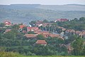
Tureni

Cheile Turului valley gorge

Mărtineşti


Web links
Individual evidence
- ↑ 2011 census in Romania at citypopulation.de
- ↑ Heinz Heltmann, Gustav Servatius (Ed.): Travel Guide Siebenbürgen. Kraft, Würzburg 1993, ISBN 3-8083-2019-2 .
- ↑ Tureni at varga.adatbank.transindex.ro (Hungarian)
Aghireșu | Aiton | Aluniș | Apahida | Aşchileu | Baciu | Băișoara | Beliș | Bobâlna | Bonțida | Borșa | Buza | Căianu | Călărași | Călățele | Cămărașu | Căpușu Mare | Cășeiu | Câțcău | Cătina | Ceanu Mare | Chinteni | Chiuieşti | Ciucea | Ciurila | Cojocna | Cornești | Cuzdrioara | Dăbâca | Feleacu | Fizeșu Gherlii | Florești | Frata | Gârbău | Geaca | Gilău | Iara | Iclod | Izvoru Crișului | Jichișu de Jos | Jucu | Luna | Măguri-Răcătău | Mănăstireni | Mărgău | Mărișel | Mica | Mihai Viteazu | Mintiu Gherlii | Mociu | Moldoveneşti | Negreni | Pălatca | Panticeu | Petreștii de Jos | Ploscoș | Poieni | Râșca | Recea-Cristur | Săcuieu | Sâncraiu | Sănduleşti | Sânmărtin | Sânpaul | Săvădisla | Sic | Suatu | Țaga | Tritenii de Jos | Tureni | Unguraș | Vad | Valea Ierii | Viișoara | Vultureni