
Cășeiu
|
Cășeiu Alsókosály |
|||||
|
|||||
| Basic data | |||||
|---|---|---|---|---|---|
| State : |
|
||||
| Historical region : | Transylvania | ||||
| Circle : | Cluj | ||||
| Coordinates : | 47 ° 12 ' N , 23 ° 51' E | ||||
| Time zone : | EET ( UTC +2) | ||||
| Height : | 241 m | ||||
| Area : | 83.28 km² | ||||
| Residents : | 4,437 (October 20, 2011) | ||||
| Population density : | 53 inhabitants per km² | ||||
| Postal code : | 407155 | ||||
| Telephone code : | (+40) 02 64 | ||||
| License plate : | CJ | ||||
| Structure and administration (as of 2016) | |||||
| Community type : | local community | ||||
| Structure : | Cășeiu, Comorâța , Coplean , Custura , Gârbău Dejului , Guga , Leurda , Rugășești , Sălătruc , Urișor | ||||
| Mayor : | Silviu Boldor ( PSD ) | ||||
| Postal address : | Str. Principală, no. 54 loc. Cășeiu, jud. Cluj, RO-407155 |
||||
| Website : | |||||


Cășeiu [ kəˈʃeiu ] ( Hungarian Alsókosály ) is a municipality in Cluj County in the Transylvania region in Romania .
Geographical location

The municipality of Cășeiu, consisting of ten villages, is located northeast of the Someș (Somesch) river on an area of about 8300 hectares in the west of the Transylvanian Basin in the north of the Cluj district. The community center is located on the Sălătruc River - a right tributary of the Someș - at the junction of Drum național 18B from Drum național 1C (here also European route 58 ) and the Dej – Jibou railway seven kilometers north of the city of Dej (Burglos) . The district capital of Cluj-Napoca (Klausenburg) is located about 60 kilometers south of Cășeiu.
history
The area of Căşeiu has been inhabited at least since Roman times, as evidenced by the Căşeiu castle (ancient, Latin name: Samum ).
The place Cășeiu was first mentioned in a document in 1216 or 1261, according to different sources. According to archaeological excavations, settlement in the region goes back to Roman times . According to Emilio Panaitescu , finds point to the Early Bronze Age , these are in the museum of the city of Dej .
In the incorporated village of Urişor (formerly Urişorul de Jos , ung. Alör ), a settlement that points to Roman times was found on the banks of the Someş, near the village mill, during archaeological excavations; called by the locals at Statia Electro , a settlement that points to the Bronze Age, found.
In the Kingdom of Hungary , today's municipality belonged to the Dés chair district in the Szolnok-Doboka County , then to the historical Someș district and, from 1950, to today's Cluj district.
The Greek Catholic wooden church Sfintii Apostoli Petru şi Pavel from the unincorporated village Leurda , late 18th century, built in 1998 according to Bistrita (Bistrita) converted to the local museum and restored.
population
The population of the municipality developed as follows:
| census | Ethnic composition | |||||||
|---|---|---|---|---|---|---|---|---|
| year | population | Romanians | Hungary | German | other | |||
| 1850 | 2.983 | 2,446 | 77 | 1 | 459 | |||
| 1920 | 4,537 | 4,248 | 91 | - | 198 | |||
| 1966 | 6,403 | 6,358 | 44 | - | 1 | |||
| 2002 | 4,882 | 4,611 | 41 | 1 | 229 | |||
| 2011 | 4,437 | 3,855 | 19th | - | 563 | |||
Since 1850 the highest number of inhabitants in the area of today's municipality was determined in 1966, at the same time that of the Romanians. The highest population of the Roma (421) was registered in 2011, that of the Magyars (285) in 1900 and that of the Romanian Germans (243) in 1890.
Attractions
- In the community center, the Cășeiu fort , built around the year 106, is located 300 meters from the right bank of the Someș and about one and a half kilometers south of Cășeiu, called Cetățele by the locals . Archaeological excavations from 1925/1926 showed that the square fort was on an area of about two and a half hectares and had a trapezoidal defense tower at each corner. The area is a listed building.
- In the incorporated village of Coplean (Hungarian Kaplyon ) the ruins of the manor house of the Hungarian aristocratic Haller family, built in the 18th century and burned down in 1920, are listed.
- In the incorporated village of Gârbău Dejului (Hungarian Désorbó ) the wooden church Sf. Arhangheli Mihail și Gavriil , built in the 18th century, is a listed building.
- In the incorporated village of Rugăşeşti (ung. Felsőkosály ) near Dealul Podului , a tower from Roman times is a listed building.

Wooden church in Gârbău Dejului

Haller fort around 1900
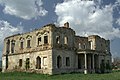
Haller Fort today


Web links
Individual evidence
- ↑ 2011 census in Romania ( MS Excel ; 1.3 MB)
- ↑ a b Heinz Heltmann, Gustav Servatius (Ed.): Travel Guide Siebenbürgen. Kraft, Würzburg 1993, ISBN 3-8083-2019-2 .
- ↑ Information on the municipality's website , accessed on August 2, 2017 (Romanian).
- ^ A b Institute Of Archeology - Cășeiu , accessed on August 2, 2017 (Romanian).
- ^ Institute Of Archeology - Urișor , accessed on August 2, 2017 (Romanian).
- ↑ a b c d e List of historical monuments of the Romanian Ministry of Culture, updated 2015 (Romanian; PDF; 12.7 MB)
- ↑ Cristiana Sabău: The wooden churches of Bistrița-Năsăud are in danger of disappearing if we don't do anything to save them. on October 6, 2013 from timponline.ro accessed on August 3, 2017 (Romanian)
- ↑ Census, last updated November 2, 2008 (Hungarian; PDF; 525 kB)
- ↑ Dan-Ionut Julean: Coplean - the fate of a family and a castle. (PDF; 9.6 MB) Accessed March 23, 2019 (Romanian).
Aghireșu | Aiton | Aluniș | Apahida | Aşchileu | Baciu | Băișoara | Beliș | Bobâlna | Bonțida | Borșa | Buza | Căianu | Călărași | Călățele | Cămărașu | Căpușu Mare | Cășeiu | Câțcău | Cătina | Ceanu Mare | Chinteni | Chiuieşti | Ciucea | Ciurila | Cojocna | Cornești | Cuzdrioara | Dăbâca | Feleacu | Fizeșu Gherlii | Florești | Frata | Gârbău | Geaca | Gilău | Iara | Iclod | Izvoru Crișului | Jichișu de Jos | Jucu | Luna | Măguri-Răcătău | Mănăstireni | Mărgău | Mărișel | Mica | Mihai Viteazu | Mintiu Gherlii | Mociu | Moldoveneşti | Negreni | Pălatca | Panticeu | Petreștii de Jos | Ploscoș | Poieni | Râșca | Recea-Cristur | Săcuieu | Sâncraiu | Sănduleşti | Sânmărtin | Sânpaul | Săvădisla | Sic | Suatu | Țaga | Tritenii de Jos | Tureni | Unguraș | Vad | Valea Ierii | Viișoara | Vultureni