
Săndulești (Cluj)
|
Săndulești Szind |
|||||
|
|||||
| Basic data | |||||
|---|---|---|---|---|---|
| State : |
|
||||
| Historical region : | Transylvania | ||||
| Circle : | Cluj | ||||
| Coordinates : | 46 ° 35 ' N , 23 ° 43' E | ||||
| Time zone : | EET ( UTC +2) | ||||
| Height : | 454 m | ||||
| Area : | 22.48 km² | ||||
| Residents : | 1,798 (October 20, 2011) | ||||
| Population density : | 80 inhabitants per km² | ||||
| Postal code : | 407500 | ||||
| Telephone code : | (+40) 02 64 | ||||
| License plate : | CJ | ||||
| Structure and administration (as of 2016) | |||||
| Community type : | local community | ||||
| Structure : | Sănduleşti, Copăceni | ||||
| Mayor : | Călin Stelian Fărgaciu ( PSD ) | ||||
| Postal address : | Str. Principală, no. 169 loc. Sănduleşti, jud. Cluj, RO-407500 |
||||
| Website : | |||||


Săndulești [ ˈsənduleʃtʲ ] (outdated Sînd or Sind ; Hungarian Szind ) is a municipality in Cluj County , in Transylvania , Romania .
Geographical location

The municipality of Sănduleşti is located in the west of the Transylvanian Basin, northeast of the Trascău Mountains ( Munții Trascăului ). On the stream of the same name (Râul Sănduleşti) - a left tributary of the Arieş - and on the district road (Drum județean) DJ 103G, the place Sănduleşti is six kilometers west of the city of Turda (Thorenburg) . The district capital Cluj-Napoca (Klausenburg) is about 33 kilometers north.
South of the community center is the lake called Tăul Mare , a smaller lake called Tăul Mic that dried up in the 1950s. The Romanian A3 motorway also runs on the area of the municipality .
history
The place Sănduleşti was first mentioned in 1176. In the Middle Ages the place was inhabited by Romanians and Magyars. The limestone quarries in the area of the place were already operated by the Romans . Archaeological finds on the area, called Pietrele rotate by the locals, point to a settlement of the place until early history , at Piatra tăită in the 2nd / 3rd centuries. Century BC . In Pietrele rotate a was hill grave the early history associated.
In the Kingdom of Hungary , today's community belonged to the chair district Torda in the County Torda-Aranyos , then the historic district of Cluj and from 1950 to today's Cluj County at.
population
The population of the municipality developed as follows:
| census | Ethnic composition | ||||
|---|---|---|---|---|---|
| year | population | Romanians | Hungary | German | other |
| 1850 | 1.002 | 799 | 156 | - | 47 |
| 1941 | 1,887 | 1,633 | 165 | 1 | 58 |
| 1966 | 2,362 | 2.145 | 182 | 1 | 34 |
| 2002 | 1,892 | 1,790 | 81 | - | 21st |
| 2011 | 1,798 | 1,647 | 67 | - | 84 (Roma 4) |
Since 1850 the highest number of inhabitants and also that of the Romanians in 1966 have been determined in the area of today's municipality. The highest population of the Magyars (241) was registered in 1880, that of the Roma (46) in 1850 and that of the Romanian Germans (18) in 1890.
Attractions
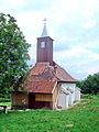
- The orthodox stone church with wooden tower Sf. Arhanghel Mihail și Gavriil and the Unitarian Church, both built in the 15th century, are listed buildings.
- Sport fishing is practiced on Lake Tăul Mare .

Unitarian Church
Orthodox Church
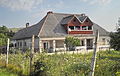
Bors mansion

Village school and library


Web links
- Săndulești at ghidulprimariilor.ro
- Sănduleşti on the Cluj County Council website
Individual evidence
- ↑ 2011 census in Romania ( MS Excel ; 1.3 MB)
- ↑ Heinz Heltmann, Gustav Servatius (Ed.): Travel Guide Siebenbürgen . Kraft, Würzburg 1993, ISBN 3-8083-2019-2 , p. 517 .
- ↑ a b List of historical monuments of the Romanian Ministry of Culture, updated 2015 (PDF; 12.7 MB; Romanian)
- ↑ Censuses 1850–2002, last updated November 2, 2008 (PDF; 1 MB; Hungarian)
- ↑ Information on the municipality's website , accessed on October 20, 2017.
Aghireșu | Aiton | Aluniș | Apahida | Aşchileu | Baciu | Băișoara | Beliș | Bobâlna | Bonțida | Borșa | Buza | Căianu | Călărași | Călățele | Cămărașu | Căpușu Mare | Cășeiu | Câțcău | Cătina | Ceanu Mare | Chinteni | Chiuieşti | Ciucea | Ciurila | Cojocna | Cornești | Cuzdrioara | Dăbâca | Feleacu | Fizeșu Gherlii | Florești | Frata | Gârbău | Geaca | Gilău | Iara | Iclod | Izvoru Crișului | Jichișu de Jos | Jucu | Luna | Măguri-Răcătău | Mănăstireni | Mărgău | Mărișel | Mica | Mihai Viteazu | Mintiu Gherlii | Mociu | Moldoveneşti | Negreni | Pălatca | Panticeu | Petreștii de Jos | Ploscoș | Poieni | Râșca | Recea-Cristur | Săcuieu | Sâncraiu | Sănduleşti | Sânmărtin | Sânpaul | Săvădisla | Sic | Suatu | Țaga | Tritenii de Jos | Tureni | Unguraș | Vad | Valea Ierii | Viișoara | Vultureni