
Mănăstireni
|
Mănăstireni monastery village Magyargyerőmonostor |
|||||
|
|||||
| Basic data | |||||
|---|---|---|---|---|---|
| State : |
|
||||
| Historical region : | Transylvania | ||||
| Circle : | Cluj | ||||
| Coordinates : | 46 ° 47 ' N , 23 ° 5' E | ||||
| Time zone : | EET ( UTC +2) | ||||
| Height : | 738 m | ||||
| Area : | 63 km² | ||||
| Residents : | 1,481 (October 20, 2011) | ||||
| Population density : | 24 inhabitants per km² | ||||
| Postal code : | 407370 | ||||
| Telephone code : | (+40) 02 64 | ||||
| License plate : | CJ | ||||
| Structure and administration (as of 2016) | |||||
| Community type : | local community | ||||
| Structure : | Mănăstireni, Ardeova , Bedeciu , Bica , Dretea , Mănăşturu Românesc | ||||
| Mayor : | Ioan Condor ( PSD ) | ||||
| Postal address : | Str. Principală, no. 222 loc. Mănăstireni, jud. Cluj, RO-407370 |
||||
| Website : | |||||


Mănăstireni [ ˈməˈnəstirenʲ ] (outdated Mănăşturulunguresc ; German monastery village , Hungarian Magyargyerőmonostor ) is a municipality in Cluj County , in Transylvania , Romania .
Geographical location

The municipality of Mănăstireni is located west of the Transylvanian Basin in the northern foothills of the Gilăuer Mountains (Munții Gilăului) , a mountain range of the Apuseni Mountains (Munții Apuseni) . On the upper reaches of the Căpuș - a left tributary of the Someșul Mic (Little Somesch) - in the west of the Cluj district and at the confluence of the DJ 103L district road (Drum județean) DJ 108C is the place Mănăstireni 20 kilometers southeast of the small town of Huedin ( Heynod) . The district capital Cluj-Napoca (Klausenburg) is about 45 kilometers to the east.
history
The place Mănăstireni was first mentioned in 1376. Its name comes from the Catholic Monostor monastery , where today's Reformed Church stands.
Archaeological finds of a settlement, called Căpâlna by the locals , on the area of the village of Mănăstireni and the ruins of a former fortification on the area of the incorporated village of Bedeciu (in Hungarian Bedecs ) indicate that the region has been settled since the Middle Ages , and Cetate by the locals called.
In the Kingdom of Hungary , today's community belonged to the chair district Bánffyhunyad in the County Cluj , then the historic district of Cluj and from 1950 to today's Cluj County at.
population
The population of the municipality developed as follows:
| census | Ethnic composition | ||||
|---|---|---|---|---|---|
| year | population | Romanians | Hungary | German | other |
| 1850 | 3,839 | 3,331 | 465 | - | 43 |
| 1920 | 6.227 | 5,592 | 606 | 6th | 23 |
| 1966 | 3,383 | 3,033 | 321 | - | 29 |
| 2002 | 1,809 | 1,554 | 198 | - | 57 |
| 2011 | 1,481 | 1,192 | 157 | - | 132 (Roma 79) |
Since 1850 the highest number of inhabitants and also that of the Romanians in 1920 have been determined in the area of today's municipality. The highest population of the Magyars (682) was registered in 1900, that of the Roma in 2011 and that of the Romanian Germans (14) in 1910.
Attractions
- In the community center the reformed church was built before the Mongol storm of 1241 and is considered the oldest reformed church in the Cluj-Napoca region. In the 15th century, a narthex with two towers was added on the west side. In 1442 the Romanesque apse was replaced by a Gothic one. Small stone figures are attached to the south side of the tower. The ceiling and benches of the church were made by the Saxon carpenters and painters family Umling from Saschiz , around 1753 or 1758. The church is a listed building.
- The manor house of the Hungarian aristocratic Kornis family, built in the 19th century, is a listed building.
- In the incorporated village of Bedeciu, the Înălțarea Domnului Orthodox Church , built in the 15th century, is a listed building.
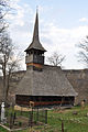
- In the incorporated village of Bica (Hungarian Kalotabikal ) the wooden church Înălțarea Domnului , built in 1756, is a listed building.
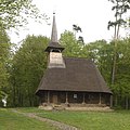
- In the incorporated village of Ardeova (Hungarian Erdőfalva ) the wooden church was built in 1826.
- The wooden church from the unincorporated village Dretea (Hungarian Deréte ) 1672 built, was demolished in 2003 and is since 2006 in the open-air museum in Sibiu .

View of Mănăstireni

Reformed Church in Mănăstireni

Wooden church in Ardeova

Orthodox Church in Bedeciu
Wooden church in Bica
Former wooden church in Dretea


.JPG)


Personalities
- Ioan Ursu (1928–2007), physicist, party member since 1956 , was President of the State Committee for Nuclear Energy (1969–1976); 1974 member of the Romanian Academy .
Web links
- Mănăstireni at ghidulprimariilor.ro
- Mănăstireni on the Cluj County Council website
- Dan Moșoiu: Mănăstireni, the village with 50 widows from radiocluj.ro (Romanian) accessed on October 27, 2017
Individual evidence
- ↑ 2011 census in Romania ( MS Excel ; 1.3 MB)
- ↑ a b c Heinz Heltmann, Gustav Servatius (ed.): Travel Guide Siebenbürgen . Kraft, Würzburg 1993, ISBN 3-8083-2019-2 , p. 517 .
- ↑ a b c d e List of historical monuments of the Romanian Ministry of Culture, updated 2015 (PDF; 12.7 MB; Romanian)
- ↑ Censuses 1850–2002, last updated November 2, 2008 (PDF; 1 MB; Hungarian)
- ↑ Information on the church in Mănăstireni from biserici.org (Romanian) accessed on October 28, 2017
- ↑ View inside the church in Mănăstireni ( page no longer available , search in web archives ) Info: The link was automatically marked as defective. Please check the link according to the instructions and then remove this notice. Retrieved from biserici.org on October 28, 2017
- ↑ Information on the church in Bedeciu from biserici.org (Romanian) accessed on October 28, 2017
- ↑ Information on the Church of Dretea from ziarullumina.ro (Romanian) accessed on October 28, 2017
- ↑ Ursu Ion (Ioan) at Consiliul Național pentru Studiera Arhivelor Securității. Membrii CC al PCR 1945-1989. Dicționar (PDF; 12.1 MB; Romanian)
- ↑ Information on Ioan Ursu from acad.ro (Romanian) accessed on October 22, 2017
Aghireșu | Aiton | Aluniș | Apahida | Aşchileu | Baciu | Băișoara | Beliș | Bobâlna | Bonțida | Borșa | Buza | Căianu | Călărași | Călățele | Cămărașu | Căpușu Mare | Cășeiu | Câțcău | Cătina | Ceanu Mare | Chinteni | Chiuieşti | Ciucea | Ciurila | Cojocna | Cornești | Cuzdrioara | Dăbâca | Feleacu | Fizeșu Gherlii | Florești | Frata | Gârbău | Geaca | Gilău | Iara | Iclod | Izvoru Crișului | Jichișu de Jos | Jucu | Luna | Măguri-Răcătău | Mănăstireni | Mărgău | Mărișel | Mica | Mihai Viteazu | Mintiu Gherlii | Mociu | Moldoveneşti | Negreni | Pălatca | Panticeu | Petreștii de Jos | Ploscoș | Poieni | Râșca | Recea-Cristur | Săcuieu | Sâncraiu | Sănduleşti | Sânmărtin | Sânpaul | Săvădisla | Sic | Suatu | Țaga | Tritenii de Jos | Tureni | Unguraș | Vad | Valea Ierii | Viișoara | Vultureni