
Iara (Romania)
|
Iara Alsójára |
|||||
|
|||||
| Basic data | |||||
|---|---|---|---|---|---|
| State : |
|
||||
| Historical region : | Transylvania | ||||
| Circle : | Cluj | ||||
| Coordinates : | 46 ° 33 ' N , 23 ° 31' E | ||||
| Time zone : | EET ( UTC +2) | ||||
| Height : | 465 m | ||||
| Area : | 143.87 km² | ||||
| Residents : | 3,889 (October 20, 2011) | ||||
| Population density : | 27 inhabitants per km² | ||||
| Postal code : | 407315 | ||||
| Telephone code : | (+40) 02 64 | ||||
| License plate : | CJ | ||||
| Structure and administration (as of 2016) | |||||
| Community type : | local community | ||||
| Structure : | Iara, Agriș , Borzești , Buru , Cacova Ierii , Făgetu Ierii , Lungești , Măgura Ierii , Mașca , Ocolișel , Surduc , Valea Agrișului , Valea Vadului | ||||
| Mayor : | Ioan Dorin Popa ( PNL ) | ||||
| Postal address : | St. Unirii, no. 282 loc. Iara, jud. Cluj, RO-407315 |
||||
| Website : | |||||


Iara ( Hungarian Alsójára ) is a municipality in Cluj County , in Transylvania , Romania .
The place is also known by the Hungarian names Felsőjára , Belsőjára and Jára .
Geographical location

The municipality of Iara is located west of the Transylvanian Basin in the northwestern foothills of the Trascău Mountains (Munții Trascăului) in the south of the Cluj district. On the creek of the same name - a left tributary of the Arieş - and on the district road (Drum județean) DJ 107M, the place Iara is 28 kilometers west of the city of Turda (Thorenburg) . The district capital Cluj-Napoca (Klausenburg) is 35 kilometers north.
history
The place Iara was first mentioned in 1176. In the Middle Ages, the place was inhabited by Transylvanian-Saxon miners who operated rich gold panning operations. From the 15th century, more and more Magyars settle here. The place was known for its fairs and also as a port and handicraft center.
According to archaeological finds of a mining settlement, according to information from E. A. Bielz and G. Téglás , settlement of the place, on the area called Groapa lui Papa (in Hungarian Pápagödre ), goes back to Roman times , or according to information from the Romanian Ministry of Culture to the early history back. Numerous archaeological objects are assigned to the Late Bronze Age . Several archaeological finds from the Late Bronze Age were also made in the incorporated village of Buru ( Borrév in Hungarian ) on the Arieș. These are located in museums in Budapest . In the incorporated village of Făgetu Ierii (outdated Bicalat or Bicălat ; Hungarian Bikalat ) a gold mine, which was assigned to Roman times, was found.
In the Kingdom of Hungary , today's municipality belonged to the Alsójára chair district - today's community center - in the Torda-Aranyos County , then to the historic Cluj County and, from 1950, to the Cluj County of today.
population
The population of the municipality developed as follows:
| census | Ethnic composition | ||||
|---|---|---|---|---|---|
| year | population | Romanians | Hungary | German | other |
| 1850 | 4.234 | 4,028 | 135 | - | 71 |
| 1930 | 6.712 | 5,773 | 730 | 11 | 198 |
| 1992 | 5,190 | 4,779 | 186 | 2 | 223 |
| 2002 | 4,704 | 4,266 | 149 | 5 | 284 |
| 2011 | 3,889 | 3,305 | 95 | 2 | 487 (Roma 285) |
Since 1850 the highest number of inhabitants (6,822) and also that of the Romanians (6,176) in 1941 have been determined in the area of today's municipality. The highest population of the Magyars (1,052) was registered in 1910, that of the Roma in 2011 and that of the Romanian Germans (25) in 1880.
Attractions
- The manor houses Beldi , Kemény and Teleki built in the 19th century in the community center are listed as historical monuments.
- The Unitarian church in Iara, built in the 13th century and redesigned around the 18th century, is a listed building.
- In the incorporated village of Borzeşti (outdated Berchiş ; Hungarian Berkes ) the Orthodox Church Sf. Arhanghel Mihail și Gavriil , built in the 18th century, is a listed building.
- In the incorporated village of Măgura Ierii (Hungarian Járamagura ) the wooden church Sfinții Arhangheli Mihail și Gavriil , built in 1783, is a listed building.
- In the incorporated village of Ocolișel (in Hungarian Felsőaklos ) the wooden church Sfinții Arhangheli Mihail și Gavriil , built in 1852, is a listed building.
- In the incorporated village of Surduc ( Hungarian : Járaszurdok ) the wooden church Sfinții Arhangheli Mihail și Gavriil , built in the 18th century, is a listed building.
- The wooden church built in the 18th century in the incorporated village of Buru.
- The wooden church Sfinții Trei Arhangheli was built in 1769 in the incorporated village of Făgetu Ierii .

Church in Iara

Church in Borzeşti

Church in Buru

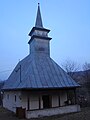
Wooden church in Cocova Ierii
Church in Făgetu Ierii

Wooden church in Ocolișel

Wooden church in Surduc

.JPG)


Personalities
- Traian Crișan (1918–1990), Curia Archbishop of the Roman Catholic Church
Web links
Individual evidence
- ↑ 2011 census in Romania ( MS Excel ; 1.3 MB)
- ↑ Information on Iara at arcanum.hu; accessed on October 15, 2017
- ↑ Heinz Heltmann, Gustav Servatius (Ed.): Travel Guide Siebenbürgen . Kraft, Würzburg 1993, ISBN 3-8083-2019-2 , p. 517 .
- ↑ a b c d e f g List of historical monuments of the Romanian Ministry of Culture, updated 2015 (PDF; 12.7 MB; Romanian)
- ^ Institute Of Archeology - Iara (Romanian). Retrieved October 16, 2017
- ^ Institute Of Archeology - Buru (Romanian). Retrieved October 16, 2017
- ↑ Institute Of Archeology - Făgetu Ierii (Romanian) Retrieved on October 16, 2017
- ↑ Censuses 1850–2002, last updated November 2, 2008 (PDF; 1 MB; Hungarian)
- ↑ Information on the wooden church in Măgura Ierii from biserici.org (Romanian) accessed on October 17, 2017
- ↑ Information on the wooden church in Buru at biserici.org (Romanian) accessed on October 17, 2017
- ↑ Information on the wooden church in Făgetu Ierii from biserici.org (Romanian) accessed on October 17, 2017
Aghireșu | Aiton | Aluniș | Apahida | Aşchileu | Baciu | Băișoara | Beliș | Bobâlna | Bonțida | Borșa | Buza | Căianu | Călărași | Călățele | Cămărașu | Căpușu Mare | Cășeiu | Câțcău | Cătina | Ceanu Mare | Chinteni | Chiuieşti | Ciucea | Ciurila | Cojocna | Cornești | Cuzdrioara | Dăbâca | Feleacu | Fizeșu Gherlii | Florești | Frata | Gârbău | Geaca | Gilău | Iara | Iclod | Izvoru Crișului | Jichișu de Jos | Jucu | Luna | Măguri-Răcătău | Mănăstireni | Mărgău | Mărișel | Mica | Mihai Viteazu | Mintiu Gherlii | Mociu | Moldoveneşti | Negreni | Pălatca | Panticeu | Petreștii de Jos | Ploscoș | Poieni | Râșca | Recea-Cristur | Săcuieu | Sâncraiu | Sănduleşti | Sânmărtin | Sânpaul | Săvădisla | Sic | Suatu | Țaga | Tritenii de Jos | Tureni | Unguraș | Vad | Valea Ierii | Viișoara | Vultureni