
Săcuieu
|
Săcuieu Zekeldorf Székelyjó |
|||||
|
|||||
| Basic data | |||||
|---|---|---|---|---|---|
| State : |
|
||||
| Historical region : | Transylvania | ||||
| Circle : | Cluj | ||||
| Coordinates : | 46 ° 49 ' N , 22 ° 53' E | ||||
| Time zone : | EET ( UTC +2) | ||||
| Height : | 620 m | ||||
| Area : | 129.46 km² | ||||
| Residents : | 1,466 (October 20, 2011) | ||||
| Population density : | 11 inhabitants per km² | ||||
| Postal code : | 407495 | ||||
| Telephone code : | (+40) 02 64 | ||||
| License plate : | CJ | ||||
| Structure and administration (as of 2016) | |||||
| Community type : | local community | ||||
| Structure : | Săcuieu, Rogojel , Vișagu | ||||
| Mayor : | Gheorghe Cuc ( ALDE ) | ||||
| Postal address : | Str. Principală, no. 130 loc. Săcuieu, jud. Cluj, RO-407495 |
||||
| Website : | |||||


Săcuieu [ ˈsəkuieu ] ( German Zekeldorf , Hungarian Székelyjó ) is a municipality in the Cluj district , in Transylvania , Romania .
The place Săcuieu is also known under the Romanian names Săcueu , Secuieu and Secuiu .
Geographical location

The municipality of Săcuieu is located in the northeast of the Vlădeasa Mountains (Munții Vlădeasa) - a mountain range of the Apuseni Mountains (Munții Apuseni) - in the west of the Cluj County. The three villages and hamlets of the municipality, of which Rogojel (Hungarian Havasrogoz ) is the highest in the municipality at 1029 m, cover a total area of almost 13,000 hectares. Săcuieu is 14 kilometers southwest of the small town of Huedin (Heynod) on the creek of the same name (also called Râul Hențu ) - a left tributary of the Crișul Repede (Rapid Screech) - and the county road (Drum județean) DJ 103H ; the district capital Cluj-Napoca (Klausenburg) is located about 65 kilometers east of Săcuieu.
history
The place Săcuieu was first mentioned in 1461 and was in the Middle Ages a Romanian Nationals village , which used to Bologa Castle ( ⊙ ) in today's community Poieni belonged.
In the Kingdom of Hungary , today's community was in the chair district Bánffyhunyad (now Huedin) in the County of Cluj . Subsequently, the municipality belonged to the historical Cluj District and from 1950 to the present Cluj District.
population
Since 1850 almost exclusively Romanians have been registered in the area of today's municipality of Săcuieu . In 1850 there were 1348 Romanians and one Roma . The highest population and that of the Romanians (3640) was determined in 1920 and since then it has steadily fallen. The highest number of Roma (191) was registered in 2011, that of Magyars (22) in 1910 and that of Romanian Germans (5) in 1880. At the 2011 census, of the 1466 people, 1238 were Romanians, 191 Roma, two were Magyars and the rest did not provide any information about their ethnicity .
The main occupations of the population are the timber industry and animal husbandry.
Attractions
- In the incorporated village of Rogojel, the church Sfinții Arhangheli Mihail și Gavriil, built in the 18th century and a house (No. 16) in the 19th century, are listed.
- In the incorporated village of Vişagu (Hungarian Viság ) a wooden church built in 1800 is almost completely destroyed and is a listed building.
- The incorporated village of Rogojel is also the starting point for the 1836 m high Vlădeasa peak .
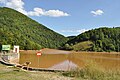
Reservoir near Săcuieu

View of Rogojel

Sequoia in Săcuieu


Web links
Individual evidence
- ↑ a b 2011 census in Romania ( MS Excel ; 1.3 MB)
- ↑ Arcanum Kézikönyvtár: Historical-administrative book of place names of Transylvania, Banat and Partium. Retrieved December 5, 2017 (Hungarian).
- ↑ Heinz Heltmann, Gustav Servatius (Ed.): Travel Guide Siebenbürgen . Kraft, Würzburg 1993, ISBN 3-8083-2019-2 , p. 517 .
- ↑ Censuses 1850–2002, last updated November 2, 2008 (PDF; 1 MB; Hungarian)
- ↑ a b List of historical monuments of the Romanian Ministry of Culture, updated 2015 (PDF; 12.7 MB; Romanian)
Aghireșu | Aiton | Aluniș | Apahida | Aşchileu | Baciu | Băișoara | Beliș | Bobâlna | Bonțida | Borșa | Buza | Căianu | Călărași | Călățele | Cămărașu | Căpușu Mare | Cășeiu | Câțcău | Cătina | Ceanu Mare | Chinteni | Chiuieşti | Ciucea | Ciurila | Cojocna | Cornești | Cuzdrioara | Dăbâca | Feleacu | Fizeșu Gherlii | Florești | Frata | Gârbău | Geaca | Gilău | Iara | Iclod | Izvoru Crișului | Jichișu de Jos | Jucu | Luna | Măguri-Răcătău | Mănăstireni | Mărgău | Mărișel | Mica | Mihai Viteazu | Mintiu Gherlii | Mociu | Moldoveneşti | Negreni | Pălatca | Panticeu | Petreștii de Jos | Ploscoș | Poieni | Râșca | Recea-Cristur | Săcuieu | Sâncraiu | Sănduleşti | Sânmărtin | Sânpaul | Săvădisla | Sic | Suatu | Țaga | Tritenii de Jos | Tureni | Unguraș | Vad | Valea Ierii | Viișoara | Vultureni