
Sânmărtin (Cluj)
|
Sânmărtin Szépkenyerűszentmárton |
|||||
|
|||||
| Basic data | |||||
|---|---|---|---|---|---|
| State : |
|
||||
| Historical region : | Transylvania | ||||
| Circle : | Cluj | ||||
| Coordinates : | 47 ° 1 ' N , 24 ° 5' E | ||||
| Time zone : | EET ( UTC +2) | ||||
| Height : | 320 m | ||||
| Residents : | 1,384 (October 20, 2011) | ||||
| Postal code : | 407520 | ||||
| Telephone code : | (+40) 02 64 | ||||
| License plate : | CJ | ||||
| Structure and administration (as of 2016) | |||||
| Community type : | local community | ||||
| Structure : | Sânmărtin, Ceaba , Cutca , Diviciorii Mari , Diviciorii Mici , Măhal , Sâmboieni , Târgușor | ||||
| Mayor : | Ioan Fartan ( PSD ) | ||||
| Postal address : | Str. Principală, no. 207 loc. Sânmărtin, jud. Cluj, RO-407520 |
||||


Sânmărtin or Sînmărtin [ sɨnˈmərtin ] ( Hungarian Szépkenyerűszentmárton or Szentmárton ) is a municipality in the Cluj County , in Transylvania , Romania .
Geographical location

The municipality of Sânmărtin is located in the north of the Transylvanian Heath ( Câmpia Transilvaniei ) - part of the Transylvanian Basin . In the east of the Cluj district on the Diviciorii Mari brook and on the district road (Drum județean) DJ 161D, the town of Sânmărtin is 14 kilometers east of the town of Gherla ( new castle ) and about 60 kilometers northeast of the district capital of Cluj-Napoca (Klausenburg) .
history
The place Sânmărtin was first mentioned in 1335, was a Hungarian village in the Middle Ages and belonged to Bálványos Castle ( ⊙ ) in today's Unguraș (castle wall) and from 1550 to today's Gherla ( new castle ) . Archaeological finds on the area, called Grajduri ("place"), in the incorporated village of Diviciorii Mari (Hungarian Nagydevecser ), indicate that the community area was settled in the Bronze Age . Archaeological finds were made in almost every village, but not all of them could be assigned to an era.
In the Kingdom of Hungary , today's municipality belonged to the Szamosújvár (now Gherla) district in the Szolnok-Doboka County , then to the historical Someș district and, from 1950, to today's Cluj district.
population
The population of the municipality developed as follows:
| census | Ethnic composition | ||||
|---|---|---|---|---|---|
| year | population | Romanians | Hungary | German | other |
| 1850 | 2,734 | 2.140 | 531 | - | 63 |
| 1900 | 3,496 | 2,758 | 662 | 38 | 38 |
| 1930 | 3,824 | 3,054 | 644 | - | 126 |
| 1992 | 2,106 | 1,868 | 215 | - | 23 |
| 2002 | 1,744 | 1,509 | 182 | - | 53 |
| 2011 | 1,384 | 1,133 | 149 | - | 102 (Roma 55) |
The highest number of inhabitants (4348) and that of the Romanians (3702) in 1956 were registered in the area of today's municipality since 1850. The highest population of the Magyars (690) was determined in 1910, that of the Roma (71) in 1930 and 1956 and that of the Romanian Germans in 1900.
Attractions
- In the incorporated village of Cutca (Hungarian Kötke ) the wooden church Sfinții Arhangheli Mihail și Gavriil , built in 1720, is a listed building.
- In the incorporated village of Diviciorii Mari the reformed church , built in the 18th century, is a listed building.
- In the incorporated village Sâmboieni (Hungarian Erdőszombattelke ) the wooden church Sfinții Arhangheli Mihail și Gavriil , built in 1753, is a listed building.
- In the incorporated village of Târgușor (outdated Oșorheiu ; Hungarian Kékesvásárhely ) the wooden church Sfinții Arhangheli Mihail și Gavriil , built in 1753, is a listed building.
- In the incorporated village of Diviciorii Mici (Klein Däwäts) the orthodox church Sfinții Arhangheli Mihail și Gavriil , was built in 1913 in place of a wooden church.

Wooden church in Cutca

Wooden church in Sâmboieni
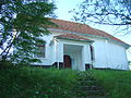
Diviciorii Mari Reformed Church

Wooden church in Târgușor


.JPG)

Web links
Individual evidence
- ↑ 2011 census in Romania ( MS Excel ; 1.3 MB)
- ↑ a b Heinz Heltmann, Gustav Servatius (Ed.): Travel Guide Siebenbürgen . Kraft, Würzburg 1993, ISBN 3-8083-2019-2 , p. 517 .
- ↑ a b c d e List of historical monuments of the Romanian Ministry of Culture, updated 2015 (PDF; 12.7 MB; Romanian)
- ^ Institute Of Archeology - Places in Cluj County , accessed on February 6, 2018 (Romanian).
- ↑ Censuses 1850–2002, last updated November 2, 2008 (PDF; 1 MB; Hungarian)
- ↑ Information on the Reformed Church in Diviciorii Mari at biserici.org, accessed on February 4, 2018 (Romanian)
- ↑ Information on the wooden church in Târgușor at biserici.org, accessed on February 4, 2018 (Romanian)
- ↑ Information on the Reformed Church in Diviciorii Mici at biserici.org, accessed on February 4, 2018 (Romanian)
Aghireșu | Aiton | Aluniș | Apahida | Aşchileu | Baciu | Băișoara | Beliș | Bobâlna | Bonțida | Borșa | Buza | Căianu | Călărași | Călățele | Cămărașu | Căpușu Mare | Cășeiu | Câțcău | Cătina | Ceanu Mare | Chinteni | Chiuieşti | Ciucea | Ciurila | Cojocna | Cornești | Cuzdrioara | Dăbâca | Feleacu | Fizeșu Gherlii | Florești | Frata | Gârbău | Geaca | Gilău | Iara | Iclod | Izvoru Crișului | Jichișu de Jos | Jucu | Luna | Măguri-Răcătău | Mănăstireni | Mărgău | Mărișel | Mica | Mihai Viteazu | Mintiu Gherlii | Mociu | Moldoveneşti | Negreni | Pălatca | Panticeu | Petreștii de Jos | Ploscoș | Poieni | Râșca | Recea-Cristur | Săcuieu | Sâncraiu | Sănduleşti | Sânmărtin | Sânpaul | Săvădisla | Sic | Suatu | Țaga | Tritenii de Jos | Tureni | Unguraș | Vad | Valea Ierii | Viișoara | Vultureni