
Panticeu
|
Panticeu Páncélcseh |
|||||
|
|||||
| Basic data | |||||
|---|---|---|---|---|---|
| State : |
|
||||
| Historical region : | Transylvania | ||||
| Circle : | Cluj | ||||
| Coordinates : | 47 ° 3 ' N , 23 ° 33' E | ||||
| Time zone : | EET ( UTC +2) | ||||
| Height : | 370 m | ||||
| Area : | 90.29 km² | ||||
| Residents : | 1,844 (October 20, 2011) | ||||
| Population density : | 20 inhabitants per km² | ||||
| Postal code : | 407445 | ||||
| Telephone code : | (+40) 02 64 | ||||
| License plate : | CJ | ||||
| Structure and administration (as of 2016) | |||||
| Community type : | local community | ||||
| Structure : | Panticeu, Cătălina , Cubleșu Someșan , Dârja , Sărata | ||||
| Mayor : | Aron Lungu ( PSD ) | ||||
| Postal address : | Str. Principală, no. 93 loc. Panticeu, jud. Cluj, RO-407445 |
||||


Panticeu ( Hungarian Páncélcseh ) is a municipality in Cluj County , in Transylvania , Romania .
The place Panticeu is also known under the Romanian outdated names Pânticeu and Panciceu .
Geographical location

The municipality of Panticeu is located in the west of the Transylvanian Basin in the Somesch Highlands (Podișul Someșan) . Am Bach Lonea - a left tributary of the Someşul Mic (Small Somes) - and on the county road (Drum Judeţean) is DJ 161 the place Panticeu about 40 kilometers west of the town of Gherla ( Neuschloss ) and about 50 kilometers north of the regional capital Cluj -Napoca ( Cluj-Napoca ) .
history
The place Panticeu was first mentioned in 1314.
In a settlement with Viile pustii (Hungarian Pusztaszölök ) in the unincorporated village Cubleşu Someşan (Hungarian Magyarköblös ) archaeological findings suggest, according to Márton Roska to the prehistory back. Numerous archaeological finds from the Bronze Age were also made on the area of the village Panticeu, called Hosszúalj by the locals , and have been in the museum in Budapest since 1891 . The archaeological finds on the Neagua area of the incorporated village of Sărata ( Szótelke in Hungarian ) have not yet been assigned to a period.
In the Kingdom of Hungary , today's municipality was in the district of Csákigorbó (today Gârbou ) in the Szolnok-Doboka County . Subsequently, the municipality belonged to the historical district of Cluj and from 1950 to the present district.
population
The population of the municipality developed as follows:
| census | Ethnic composition | ||||
|---|---|---|---|---|---|
| year | population | Romanians | Hungary | German | other |
| 1850 | 3,400 | 2,676 | 488 | 2 | 234 |
| 1920 | 4,433 | 3,768 | 475 | - | 190 |
| 1941 | 5,487 | 4,433 | 875 | 1 | 178 |
| 1977 | 3,396 | 3,082 | 179 | - | 135 |
| 2002 | 2,001 | 1,706 | 84 | 1 | 210 |
| 2011 | 1,844 | 1,420 | 68 | - | 356 (Roma 242) |
Since 1850 the highest number of inhabitants was registered in the area of today's municipality in 1941. The highest population of Romanians (4653) was registered in 1956, the Magyars in 1941, the Roma in 2011 and that of the Romanian Germans (80) in 1910. In addition, a Slovak , Ukrainian or Serb was recorded in some of the censuses .
The main occupations of the population are agriculture and livestock.
Attractions
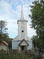
- In Panticeu the reformed church built in the 17th century is a listed building.
- In the incorporated village of Cătălina (Hungarian Szentkatolna ) the wooden church Înălțarea Sfintei Cruci built in 1896 is a listed building.
- The Reformed Church, built in 1774 in the incorporated village of Cubleşu Someşan, is a listed building.
- In unincorporated village Darya (Hungarian Magyarderzse the Reformed Church in the 13th century built) and renewed in the 15th, is a listed building.

Reformed Church in Panticeu

Reformed Church in Cubleşu Someşan

Wooden church in Cătălina
Orthodox Church in Cubleşu Someşan
.JPG)
.JPG)

.JPG)
Web links
Individual evidence
- ↑ 2011 census in Romania ( MS Excel ; 1.3 MB)
- ↑ Arcanum Kézikönyvtár: Historical-administrative book of place names of Transylvania, Banat and Partium. Retrieved December 5, 2017 (Hungarian).
- ↑ Heinz Heltmann, Gustav Servatius (Ed.): Travel Guide Siebenbürgen . Kraft, Würzburg 1993, ISBN 3-8083-2019-2 , p. 517 .
- ↑ Institute Of Archeology - Cubleşu Someşan (Romanian) Retrieved on January 3, 2018
- ↑ Institute Of Archeology - Panticeu (Romanian) Retrieved on January 3, 2018
- ^ Institute Of Archeology - Sărata (Romanian). Retrieved January 3, 2018
- ↑ Censuses 1850–2002, last updated November 2, 2008 (PDF; 1 MB; Hungarian)
- ↑ a b c d List of historical monuments of the Romanian Ministry of Culture, updated 2015 (PDF; 12.7 MB; Romanian)
- ↑ Information on the church in Dârja at biserici.org (Romanian) accessed on October 28, 2017
Aghireșu | Aiton | Aluniș | Apahida | Aşchileu | Baciu | Băișoara | Beliș | Bobâlna | Bonțida | Borșa | Buza | Căianu | Călărași | Călățele | Cămărașu | Căpușu Mare | Cășeiu | Câțcău | Cătina | Ceanu Mare | Chinteni | Chiuieşti | Ciucea | Ciurila | Cojocna | Cornești | Cuzdrioara | Dăbâca | Feleacu | Fizeșu Gherlii | Florești | Frata | Gârbău | Geaca | Gilău | Iara | Iclod | Izvoru Crișului | Jichișu de Jos | Jucu | Luna | Măguri-Răcătău | Mănăstireni | Mărgău | Mărișel | Mica | Mihai Viteazu | Mintiu Gherlii | Mociu | Moldoveneşti | Negreni | Pălatca | Panticeu | Petreștii de Jos | Ploscoș | Poieni | Râșca | Recea-Cristur | Săcuieu | Sâncraiu | Sănduleşti | Sânmărtin | Sânpaul | Săvădisla | Sic | Suatu | Țaga | Tritenii de Jos | Tureni | Unguraș | Vad | Valea Ierii | Viișoara | Vultureni