
Sâncraiu (Cluj)
|
Sâncraiu Kalotaszentkirály |
|||||
|
|||||
| Basic data | |||||
|---|---|---|---|---|---|
| State : |
|
||||
| Historical region : | Transylvania | ||||
| Circle : | Cluj | ||||
| Coordinates : | 46 ° 50 ′ N , 22 ° 59 ′ E | ||||
| Time zone : | EET ( UTC +2) | ||||
| Height : | 597 m | ||||
| Area : | 56.83 km² | ||||
| Residents : | 1,633 (October 20, 2011) | ||||
| Population density : | 29 inhabitants per km² | ||||
| Postal code : | 407515 | ||||
| Telephone code : | (+40) 02 64 | ||||
| License plate : | CJ | ||||
| Structure and administration (as of 2016) | |||||
| Community type : | local community | ||||
| Structure : | Sâncraiu, Alunișu , Brăișoru , Domoșu , Horlacea | ||||
| Mayor : | Andrei-Gheorghe Póka ( UDMR ) | ||||
| Postal address : | Str. Principală, no. 340 loc. Sâncraiu, jud. Cluj, RO-407515 |
||||
| Website : | |||||


Sâncraiu or Sîncraiu [ sɨnˈkraiu ] (outdated Calota-Sîn-Craiu or Zamsâncraiu ; Hungarian Kalotaszentkirály or Szentkirály ) is a municipality in the Cluj County , in Transylvania , Romania .
Geographical location

The municipality of Sâncraiu is located in the northern foothills of the Gilăuer Mountains (Munții Gilăului) - a mountain range of the Apuseni Mountains (Munții Apuseni) - in western Transylvania. The incorporated villages are located four to eight kilometers from the community center on a total area of around 5700 hectares. The village of Sâncraiu is located on the Călata brook - a left tributary of the Rapid Kreisch (Crișul Repede) - and on the Drum național 1R national road in the west of the Cluj district five kilometers south of the small town of Huedin (Heynod) and about 55 kilometers west of the district capital Cluj -Napoca ( Cluj ) away.
history
The place Sâncraiu was first mentioned in 1332. The remains of a castle were found during archaeological excavations on the site, but this could not yet be assigned to an era. Archaeological finds on the area, called Vârful Turdanului , in the incorporated village of Domoșu (in Hungarian Kalotadámos ) indicate that the community area was settled in the Bronze Age .
In the Kingdom of Hungary , today's community belonged to the chair district Bánffyhunyad (now Huedin) in the County Cluj , then the historic district of Cluj and from 1950 to today's Cluj County at.
The place Sâncraiu is also known because of the strikingly designed Hungarian folk costume compared to the rest of the region.
population
The population of the municipality developed as follows:
| census | Ethnic composition | ||||
|---|---|---|---|---|---|
| year | population | Romanians | Hungary | German | other |
| 1850 | 1,632 | 625 | 992 | 1 | 14th |
| 1920 | 3,795 | 1,505 | 2,227 | 11 | 52 |
| 1941 | 3,788 | 1,398 | 2,374 | 1 | 15th |
| 1992 | 2,053 | 555 | 1,498 | - | - |
| 2002 | 1,856 | 457 | 1,396 | - | 3 |
| 2011 | 1,633 | 332 | 1,281 | 1 | 19th |
Since 1850 the highest number of inhabitants (3875) and that of the Romanians (1607) in 1930 were registered in the area of today's municipality. The highest population of the Magyars was determined in 1941, that of the Roma (17) in 1977 and that of the Romanian Germans in 1920.
The wooden sculpture was and is the favorite craft of the locals. The courtyard and front doors are provided with numerous depictions of plants, birds, sun and moon as well as various inscriptions.
Attractions
- In the community center the reformed church , built in the 13th century and renewed in the 15th century. The southwest portal is a woodwork from 1742. The mountain church is a listed building.
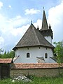
- In the incorporated village of Alunișu (Hungarian Magyarókereke ) the reformed church, built in the 13th century and renovated in the 19th century, is a listed building. The village's Orthodox church was built in the 19th century.
- In the incorporated village of Domoșu, the reformed church, built (according to different statements) in the 13th or 18th century, is a listed building. The tower with its four turrets has a Renaissance portal and the six panels on the west gallery as well as the 82 ceiling cassettes were painted by the Transylvanian Saxon Lorenz Umling . The crown of the pulpit was built in 1701.
- In the community center the monument and a linden tree in honor of the poet Endre Ady , who visited relatives here in 1914 and wrote the poem “Pe malul Călatei” .
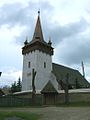
Reformed Church in Sâncraiu

Reformed Church in Alunișu

Orthodox Church in Alunișu and a bust of Avram Iancu
Reformed Church in Domoșu

Reformed Church in Horlacea

.JPG)
.JPG)


Web links
- Sâncraiu at ghidulprimariilor.ro
- Sâncraiu on the Cluj County Council website
- The municipality of Sâncraiu at cluj.com
Individual evidence
- ↑ 2011 census in Romania ( MS Excel ; 1.3 MB)
- ↑ Arcanum Kézikönyvtár: Historical-administrative book of place names of Transylvania, Banat and Partium. Retrieved February 3, 2018 (Hungarian).
- ↑ a b c d Heinz Heltmann, Gustav Servatius (Ed.): Travel Guide Siebenbürgen . Kraft, Würzburg 1993, ISBN 3-8083-2019-2 , p. 517 .
- ^ Institute Of Archeology - Sâncraiu , accessed February 3, 2018 (Romanian).
- ↑ a b c d List of historical monuments of the Romanian Ministry of Culture, updated 2015 (PDF; 12.7 MB; Romanian)
- ↑ Censuses 1850–2002, last updated November 2, 2008 (PDF; 1 MB; Hungarian)
- ↑ Information on the Reformed Church in Domoșu at biserici.org, accessed on February 4, 2018 (Romanian)
- ↑ Picture with the monument to Endre Ady
- ↑ The memorial and the linden tree of the poet Ady Endre at cluj.com, accessed on February 3, 2018
Aghireșu | Aiton | Aluniș | Apahida | Aşchileu | Baciu | Băișoara | Beliș | Bobâlna | Bonțida | Borșa | Buza | Căianu | Călărași | Călățele | Cămărașu | Căpușu Mare | Cășeiu | Câțcău | Cătina | Ceanu Mare | Chinteni | Chiuieşti | Ciucea | Ciurila | Cojocna | Cornești | Cuzdrioara | Dăbâca | Feleacu | Fizeșu Gherlii | Florești | Frata | Gârbău | Geaca | Gilău | Iara | Iclod | Izvoru Crișului | Jichișu de Jos | Jucu | Luna | Măguri-Răcătău | Mănăstireni | Mărgău | Mărișel | Mica | Mihai Viteazu | Mintiu Gherlii | Mociu | Moldoveneşti | Negreni | Pălatca | Panticeu | Petreștii de Jos | Ploscoș | Poieni | Râșca | Recea-Cristur | Săcuieu | Sâncraiu | Sănduleşti | Sânmărtin | Sânpaul | Săvădisla | Sic | Suatu | Țaga | Tritenii de Jos | Tureni | Unguraș | Vad | Valea Ierii | Viișoara | Vultureni