
Poieni (Cluj)
|
Poieni Kissebes |
|||||
|
|||||
| Basic data | |||||
|---|---|---|---|---|---|
| State : |
|
||||
| Historical region : | Transylvania | ||||
| Circle : | Cluj | ||||
| Coordinates : | 46 ° 55 ' N , 22 ° 52' E | ||||
| Time zone : | EET ( UTC +2) | ||||
| Height : | 482 m | ||||
| Area : | 190 km² | ||||
| Residents : | 4,842 (October 20, 2011) | ||||
| Population density : | 25 inhabitants per km² | ||||
| Postal code : | 407470 | ||||
| Telephone code : | (+40) 02 64 | ||||
| License plate : | CJ | ||||
| Structure and administration (as of 2016) | |||||
| Community type : | local community | ||||
| Structure : | Poieni, Bologa , Cerbeşti , Hodişu , Lunca Vişagului , Morlaca , Tranişu , Valea Drăganului | ||||
| Mayor : | Gheorghe Constantin Boca ( PNL ) | ||||
| Postal address : | Str. Principală, no. 268 loc. Poieni, jud. Cluj, RO-407470 |
||||
| Website : | |||||


Poieni [ ˈpoienʲ ] (obsolete Sebeşu Mic or Poeni ; Hungarian Kissebes ) is a municipality in Cluj County , in Transylvania , Romania .
Geographical location

The municipality of Poieni is located in the northeastern foothills of the Vlădeasa Mountains (Munții Vlădeasa) , a mountain range of the Apuseni Mountains (Munții Apuseni) . On the Crișul Repede (Rapid Screeching) , the Oradea – Cluj-Napoca railway and the national road 1 - section of the European route 60 - the elongated street village of Poieni is located in the east of the Cluj district nine kilometers west of the small town of Huedin and about 65 kilometers northwest of the District capital Cluj-Napoca (Klausenburg) .
history

Poieni was first mentioned in a document in 1496 and in the Middle Ages was a Romanian serf village which belonged to the Bologa Castle ( ⊙ ).
Archaeological finds on the Carpin , Cetățuia and Dosul Marcului mountains , mentioned by the locals, indicate that the area was settled back in Roman times , the last on the area of the incorporated village of Hodișu ( Hodosfalva in Hungarian ).
After Poieni was destroyed several times in the 16th and 17th centuries, the place was repopulated in 1700. The place is also known for the beautiful folk costumes and wood carvings.
In the Kingdom of Hungary , today's community belonged to the chair district Bánffyhunyad in the County Cluj , then the historic district of Cluj and from 1950 to today's Cluj County at.
population
The population of the municipality developed as follows:
| census | Ethnic composition | ||||
|---|---|---|---|---|---|
| year | population | Romanians | Hungary | German | other |
| 1850 | 3,042 | 2,976 | 25th | - | 41 |
| 1930 | 8,652 | 8,314 | 147 | 15th | 176 |
| 1977 | 8,646 | 8,488 | 119 | 4th | 35 |
| 2002 | 5,781 | 5,561 | 29 | 1 | 190 |
| 2011 | 4,842 | 4,445 | 27 | 3 | 367 (Roma 251) |
The highest number of inhabitants (8874) and that of the Magyars (772) in 1941 were determined in the area of today's municipality of Poieni since 1850. The highest number of Romanians was registered in 1977, that of Roma in 2011 and that of Romanian Germans (78) in 1900. In addition, Ukrainians (10; highest number in 1930) and Slovaks (22; highest number in 1900) identified themselves in some censuses .
The main occupations of the population are in the nearby quarries and the timber industry.
Attractions
- In the Poieni community center, the Roman-era towers at Măgura Sebeşului , Carpen , Cetățuia and a Roman wall at Dâmbul Vărădeştilor are listed monuments, and the Orthodox church was built at the end of the 19th century.
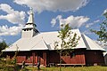
- The ruins of a castle built in the 13th century in the incorporated village of Bologa ( Sebesvár in Hungarian ) are listed, the auxiliary fort Resculum ( ⊙ ) a water mill ( ⊙ ) and the Orthodox church built in 1929.
- In the incorporated village of Tranișu (Hungarian Tranyis ) the orthodox wooden church Sfinții Arhangheli Mihail și Gavriil
- In unincorporated village Hodişu (Hungarian Hodosfalva ) the Orthodox Church Înălţarea Sfintei Cruci built 1936th
- In unincorporated village Morlaca (Hungarian Marótlaka ) the Orthodox Church in 1735 built.
- The Drăgan reservoir below the confluence of the river of the same name with the Sebeșel has a 120 meter high, 856 meter long arch dam ( ⊙ ) and went into operation in 1985. The hydropower plant with the two Francis turbines of around 146 megawatts produces an average of around 200 GWh of electrical energy per year.

Castle ruins in Bologa

Orthodox Church in Bologa
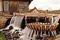
Water mill in Bologa
Wooden church in Tranișu

Former wooden church in Valea Drăganului
.JPG)


.JPG)

Personalities
- Alexandru Dejeu (1923-1958), doctor, member of the PNȚ (Partidul Național-Țărănesc) - Maniu and anti-communist , was executed by shooting on August 2, 1958 in Gherla .
- Gavril Dejeu (* 1932), brother of Alexandru Dejeu, a member of the PNȚCD, was Interior Minister in the Victor Ciorbea cabinet from 1996 to 1998 .
Web links
- Poieni at ghidulprimariilor.ro
- Poieni on the Cluj County Council website
- Web presentation of the incorporated village of Morlaca: Fotografii vechi si noi. morlaca.ro, accessed November 19, 2017 (Romanian).
Individual evidence
- ↑ 2011 census in Romania ( MS Excel ; 1.3 MB)
- ↑ a b Heinz Heltmann, Gustav Servatius (Ed.): Travel Guide Siebenbürgen . Kraft, Würzburg 1993, ISBN 3-8083-2019-2 , p. 517 .
- ^ Institute Of Archeology: Poieni. cimec.ro, accessed November 19, 2017 (Romanian).
- ↑ Censuses 1850–2002, last updated November 2, 2008 (Hungarian; PDF; 1 MB;)
- ↑ a b List of historical monuments of the Romanian Ministry of Culture, updated 2015 (PDF; 12.7 MB; Romanian)
- ↑ BISERICI.org: Biserica Ortodoxă, Poieni. Retrieved November 21, 2017 (Romanian).
- ↑ BISERICI.org: Biserica Ortodoxă, Bologa. Retrieved November 21, 2017 (Romanian).
- ↑ BISERICI.org: Biserica Ortodoxa, Hodişu. Retrieved November 21, 2017 (Romanian).
- ↑ Web representation of the incorporated village of Morlaca: Biserica Ortodoxă din Morlaca. (No longer available online.) Archived from the original on December 1, 2017 ; Retrieved November 21, 2017 (Romanian). Info: The archive link was inserted automatically and has not yet been checked. Please check the original and archive link according to the instructions and then remove this notice.
- ↑ PROIECTE: Barajul Dragan si CHE Remeti. hidroconstructia.com, accessed on November 21, 2017 (Romanian).
- ↑ Picture of the wooden church next to today's Orthodox church
- ↑ Oana Ionel: Alexandru Dejeu şi Securitate. ( PDF ; 321 kB) Retrieved on November 19, 2017 (Romanian).
- ↑ Camera Deputailor: Gavril DEJEU. cdep.ro, accessed November 19, 2017 (Romanian).
Aghireșu | Aiton | Aluniș | Apahida | Aşchileu | Baciu | Băișoara | Beliș | Bobâlna | Bonțida | Borșa | Buza | Căianu | Călărași | Călățele | Cămărașu | Căpușu Mare | Cășeiu | Câțcău | Cătina | Ceanu Mare | Chinteni | Chiuieşti | Ciucea | Ciurila | Cojocna | Cornești | Cuzdrioara | Dăbâca | Feleacu | Fizeșu Gherlii | Florești | Frata | Gârbău | Geaca | Gilău | Iara | Iclod | Izvoru Crișului | Jichișu de Jos | Jucu | Luna | Măguri-Răcătău | Mănăstireni | Mărgău | Mărișel | Mica | Mihai Viteazu | Mintiu Gherlii | Mociu | Moldoveneşti | Negreni | Pălatca | Panticeu | Petreștii de Jos | Ploscoș | Poieni | Râșca | Recea-Cristur | Săcuieu | Sâncraiu | Sănduleşti | Sânmărtin | Sânpaul | Săvădisla | Sic | Suatu | Țaga | Tritenii de Jos | Tureni | Unguraș | Vad | Valea Ierii | Viișoara | Vultureni