
Mihai Viteazu (Cluj)
| Mihai Viteazu | |||||
|
|||||
| Basic data | |||||
|---|---|---|---|---|---|
| State : |
|
||||
| Historical region : | Transylvania | ||||
| Circle : | Cluj | ||||
| Coordinates : | 46 ° 32 ' N , 23 ° 45' E | ||||
| Time zone : | EET ( UTC +2) | ||||
| Height : | 331 m | ||||
| Area : | 47.57 km² | ||||
| Residents : | 5,423 (October 20, 2011) | ||||
| Population density : | 114 inhabitants per km² | ||||
| Postal code : | 407405 | ||||
| Telephone code : | (+40) 02 64 | ||||
| License plate : | CJ | ||||
| Structure and administration (as of 2016) | |||||
| Community type : | local community | ||||
| Structure : | Mihai Viteazu, Cheia , Corneşti | ||||
| Mayor : | Ioan Zeng ( UDMR ) | ||||
| Postal address : | Str. Principală, no. 1014 loc. Mihai Viteazu, jud. Cluj, RO-407405 |
||||
| Website : | |||||


Mihai Viteazu is a municipality in Cluj County , in Transylvania , Romania .
Geographical location

The municipality of Mihai Viteazu is located in the west of the Transylvanian Basin northeast of the Trascău Mountains ( Munții Trascăului ) in the historic Torda-Aranyos County . The place is on the Arieș River and on the national road DN 75 three and a half kilometers southwest of Turda (Thorenburg) , the district capital Cluj-Napoca (Klausenburg) is about 35 kilometers north.
The Romanian A3 motorway, also known as Autostrada Transilvania , runs here on the eastern edge of the community center.
history
Originally made up of two localities - the eastern Sânmihaiu de Jos (Hungarian Alsószentmihályfalva or A: Sz: Mihályfalva .) And the western Sânmihaiu de Sus (Hungarian Felsőszentmihályfalva or F: Sz: Mihályfalva ) - Mihai Viteazu was first mentioned in documents in 1291 . Archaeological finds - in the area called Bodocul de Mijloc (ung. Középbodok) by the locals - point to a settlement in the region as far back as the Neolithic Age . According to B. Orbán, I. Téglás and Ion I. Russu and others, on the area of today's cultural center in Mihai Viteazu (formerly Wolff estate ) a. made numerous finds which point to dwellings from the Roman era.
Numerous archaeological finds were made on the left bank of the Arieș on the area of the incorporated village of Cheia ( Hungarian Méskő ) and also on the left bank of the Hăşdate brook on the area of the incorporated village of Corneşti (Hungarian Sinfalva ). The latter can be seen in numerous museums in Romania and also in Hungary.
In the Kingdom of Hungary , today's municipality belonged to the Torda District in Torda-Aranyos County , then to the historical Turda District and, from 1950, today's Cluj District.
population
In 1850, 3229 people lived in the area that is now the municipality. 1489 were Romanians , 1587 were Magyars , 149 were Roma and two were Germans . The largest population (6043) was determined in 1977. The highest number of Romanians (4094) was registered in 2002, that of Magyars (2434) and that of Roma (219) was registered in 1930, that of Romanian Germans (9) in 1941 and 1966. In addition, Ukrainians , Serbs and Slovaks were also registered on the territory of the municipality . The 2011 census showed a population of 5423 inhabitants in the municipality. Of these, 3864 were Romanians, 1314 Hungarians, 81 Roma, three Germans, three Italians , the rest were registered without any ethnic information.
Attractions
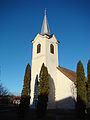
- In Mihai Viteazu, the Reformed Church built between 1674 and 1684, the Unitarian Church in the 18th century and the Roman Catholic Church in the 19th century are listed as historical monuments.
- The Unitarian Church was built in the 18th century in the incorporated villages of Cheia, and the Roman Catholic Church of Sf. Emilia was built in 1774 and is a listed building.

In Mihai Viteazu the Reformed Church
... the Unitarian Church,
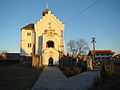
... the Roman Catholic Church,

... and the Adormirea Maicii Domnului Church

.JPG)
.JPG)
.JPG)
Personalities
- Oliviu Gherman (* 1930), physicist and politician
Web links
Individual evidence
- ↑ a b 2011 census in Romania ( MS Excel ; 1.3 MB)
- ↑ a b c Heinz Heltmann, Gustav Servatius (ed.): Travel Guide Siebenbürgen. Kraft, Würzburg 1993, ISBN 3-8083-2019-2 .
- ↑ a b Information in the map project of the Josephinische Landesaufnahme
- ^ Institute Of Archeology - Mihai Viteazu , accessed December 6, 2016 (Romanian).
- ↑ a b c List of historical monuments of the Romanian Ministry of Culture, updated 2015 (PDF; 12.7 MB)
- ^ Institute Of Archeology - Cornești , accessed December 6, 2016 (Romanian).
- ↑ Census, last updated November 2, 2008 (Hungarian; PDF; 525 kB)
- ↑ Information on the church in Cheia from biserici.org accessed on December 9, 2016 (Romanian)
- ↑ Information on the church in Corneşti from biserici.org accessed on December 9, 2016 (Romanian)
- ↑ Gherman's CV at romania-on-line.net accessed on December 3, 2016 (English)
- ↑ Information on Oliviu Gherman on the website of the Romanian Parliament , accessed on December 3, 2016 (multilingual).
Aghireșu | Aiton | Aluniș | Apahida | Aşchileu | Baciu | Băișoara | Beliș | Bobâlna | Bonțida | Borșa | Buza | Căianu | Călărași | Călățele | Cămărașu | Căpușu Mare | Cășeiu | Câțcău | Cătina | Ceanu Mare | Chinteni | Chiuieşti | Ciucea | Ciurila | Cojocna | Cornești | Cuzdrioara | Dăbâca | Feleacu | Fizeșu Gherlii | Florești | Frata | Gârbău | Geaca | Gilău | Iara | Iclod | Izvoru Crișului | Jichișu de Jos | Jucu | Luna | Măguri-Răcătău | Mănăstireni | Mărgău | Mărișel | Mica | Mihai Viteazu | Mintiu Gherlii | Mociu | Moldoveneşti | Negreni | Pălatca | Panticeu | Petreștii de Jos | Ploscoș | Poieni | Râșca | Recea-Cristur | Săcuieu | Sâncraiu | Sănduleşti | Sânmărtin | Sânpaul | Săvădisla | Sic | Suatu | Țaga | Tritenii de Jos | Tureni | Unguraș | Vad | Valea Ierii | Viișoara | Vultureni