US Highway 53
| map | |
|---|---|

|
|
| Basic data | |
| Overall length: | 403 mi / 649 km |
| Opening: | 1926 |
| States: |
Wisconsin Minnesota |
| Starting point: |
|
| End point: |
|
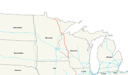
The US Highway 53 (in short: US 53) is a United States highway in the United States . It connects US Highways 14 and 61 to the west of La Crosse , Wisconsin, with the Canadian border near Fort Frances .
US 53 forms the so-called Falls-to-Falls Corridor between Chippewa Falls in Wisconsin and International Falls in Minnesota . This section should be particularly preferred and expanded when investing in infrastructure.
course
Wisconsin
US Highway 53 leaves La Crosse heading north and uses the route of Interstate 90 for about two kilometers south of La Crosse Municipal Airport . It branches off the interstate as a freeway in a northerly direction and passes smaller towns such as Galesville , Blair and Whitehall . West of Osseo, near Interstate 94 , it shares a route with US Highway 10 for about five kilometers . Then US 53 to Eau Claire runs parallel to I-94.
In the southeast of Eau Claire, the highway first crosses Interstate 94 and shortly afterwards meets US Highway 12 . It leaves the city as a freeway and meets south of Chippewa Falls on Wisconsin State Route 29, which is also a freeway . In the south of Cameron, US 53 crosses US Highway 8 . Between Spooner and Trego he uses the route of the US Highway 63 for a few kilometers and then crosses the St. Croix River .
US Highway 53 forms bypasses around places like Minong and Solon Springs . From Amnicon Falls State Park it runs along the US Highway 2 in a north-westerly direction. In the east of Superior they separate again before US 53 in the north of the city together with Interstate 535 on the John A. Blatnik Bridge crosses Saint Louis Bay and reaches the border with Minnesota.
Minnesota
In Duluth the highway leaves the route of the feeder I-535 after the intersection with Interstate 35 and then runs in a north-westerly direction. The US Highway 53 passes Duluth International Airport in the north and from the junction of Minnesota State Route 33 in Independence it leads north through largely sparsely populated areas. In Virginia , US Highway 169 branches off in a westerly direction.
In the south of International Falls, US 53 passes Falls International Airport . Together with US Highway 71 , US Highway 53 ends after crossing the Rainy River at the Canadian border. After 649 kilometers it merges into Ontario Highways 11 and 71 , which are part of the Trans-Canada Highway System.
Web links
- US Highway Ends (English)
Individual evidence
- ↑ US Highways: From US 1 to (US 830) ( Memento of the original from February 15, 2006 in the Internet Archive ) Info: The archive link was inserted automatically and has not yet been checked. Please check the original and archive link according to the instructions and then remove this notice. , accessed August 4, 2009
- ↑ AARoads: US 53 Falls to Falls (Corridor 41) , accessed August 4, 2009
- ↑ Minnesota Demographic Center: Population Estimates ( Memento of the original from March 7, 2008 in the Internet Archive ) Info: The archive link was automatically inserted and has not yet been checked. Please check the original and archive link according to the instructions and then remove this notice. , accessed August 4, 2009
