Upper Carinthia
Upper Carinthia is the western, geographically higher part of the southernmost Austrian state of Carinthia .
Upper Carinthia as a scenic region
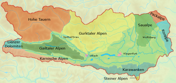
The name, which is not quite clear-cut, covers an area of around 6,000 square kilometers, which essentially consists of the area of the Hohe Tauern , the Gurktal Alps , the Gailtal Alps and the Carnic Alps . The urban center is Spittal an der Drau . Most of the area is over 1,000 m, alpine to high alpine .
The terminological demarcation to Lower Carinthia runs roughly along the line Arnoldstein , Villach , Feldkirchen and Gurk . Upper Carinthia includes the political districts of Spittal an der Drau , Hermagor and parts of the districts of Villach-Land and Feldkirchen . In the Feldkirchen district, the border runs roughly as the crow flies from the town of Feldkirchen to Sirnitz on to Hochrindl , Ebene Reichenau and Turracher Höhe , i.e. including the communities of Reichenau , Gnesau , Himmelberg , Ossiach and Steindorf am Ossiacher See . Central rivers are the Drau and Gail , which flow from west to east . The highest point is the Großglockner .
Spittal an der Drau is currently the economic and cultural center of Upper Carinthia, which lies at the intersection of the Drautal , Mölltal , Liesertal and the Millstätter See valley / area valley . Other cities are Gmünd , Radenthein and Hermagor . In today's parlance, Villach is often no longer seen as part of Upper Carinthia, but was considered the capital of Upper Carinthia in the past.
NUTS breakdown: AT212
In the official statistics of the EU led NUTS headings from is Oberkärnten one of the three groups of districts (level NUTS: AT -2) in Carinthia, carries the code AT212and includes three administrative districts :
history
The oldest traces of settlement in Upper Carinthia were found near Sappl and Lammersdorf near Lake Millstätter See , where a Neolithic settlement from 3,000 to 1,900 BC. Existed. The first tangible population by name are the Illyrians . Mountain and river names such as the Tauern or the Drau go back to their Indo-European language . From approx. 200 BC Most of Upper Carinthia belonged to the tribal area of the Ambidravi , the "both sides of the Drau residents", a Roman name for the Noric population settling here, which arose from the resident Illyrians and the newly immigrated Celts. The main town was most likely a settlement near Teurnia am Lurnfeld . Over the centuries, the place four kilometers west of Spittal, today's St. Peter in Holz bei Lendorf , developed into one of the largest cities of Noricum , which from the 1st half of the 5th century also became the capital of the Roman province of Noricum Mediterraneum ("Inner Noricum") was and thus the dominant center of power in Upper Carinthia for a long time.
Probably the oldest Carinthian monastery, founded between 722 and 788, is ten kilometers away in Molzbichl . The spiritual center was Millstatt Abbey from around the year 1100 . The largest rulers in the Middle Ages were the counties of Ortenburg and Lurn . From 1524, the Ortenburgers made Spittal the center of power ( Porcia Castle ).
With the administrative reforms of Maria Theresa, the Villach district was set up, which initially comprised Upper Carinthia. At the time of the French Wars 1809-14, it was extended to include East Tyrol as the Carinthie department of the Illyrian provinces of France. The border ran from 1809 to 1813 east of Rosegg , Velden and Feldkirchen to Turrach. After the reintegration of Upper Carinthia, the district existed until 1848, when it came to the Klagenfurt district as part of the administrative reforms when some smaller districts were dissolved , which thus included all of Carinthia except for the statutory city of Klagenfurt.
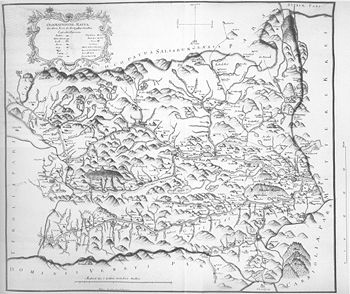
The probably oldest map of the Upper District in the Duchy of Carnthen dates from around 1750, the time of the beginning of the Josephinian land survey by cartographer NJ Surgant (1702–1763). The border with Lower Carinthia runs on the Geographical Map east of the Canal Valley near Raibl , over the Wurzenpass , through the Faaker See , past Villach in the east, through the Ossiacher See , to Gnesau and then east of the Turrach further north.
literature
- Gotbert Moro: Upper Carinthia north of the Drau . In: Archives for patriotic history and topography . tape 53 . Holzhausen, 1959 (also: Historical Atlas of the Austrian Alpine Countries, Volume 3; Part 2 also: Explanations of the Historical Atlas of the Austrian Alpine Countries, Part 8).
Web links
Individual evidence
- ↑ In contrast: Entry on Upper Carinthia in the Austria Forum (in the AEIOU Austria Lexicon )
- ^ Adolph Schaubach, The German Alps. Volume V: The south-eastern Tyrol and Styria, Lungau, Carinthia, Krain, Görz and the coastal region (Jena 1867), p. 139.
- ^ Ambros Eichhorn, Additions to the ancient history and topography of the Duchy of Carinthia. Volume 2 (Klagenfurt 1819), p. 205.
- ↑ According to the illustration of the map after Martin Wutte : Division of the Villach district in the French period 1812-1814. In: History Association for Carinthia: Buelletin. First half of 2009. Klagenfurt, 2009, p. 12.
- ↑ Map archive of Kačina Castle near Kutná Hora (Kuttenberg) in the Czech Republic . Cf. Ota Pokorný: A previously unknown map of Upper Carinthia from Surgant. In: Carinthia I. Journal for historical regional studies of Carinthia . 181st year. 1991, pp. 339-345.

