Von der Heydt (Saarbrücken)

Von der Heydt is a settlement and a district of the city of Saarbrücken in Saarland . The settlement was built on the Von der Heydt coal mine, which was operated between 1850 and 1932, and is located in the Saar coal forest between the Saarbrücken district of Rastpfuhl in the south and the municipality of Riegelsberg in the north.
Mining
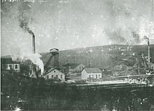
The mine - named after the banker and Prussian trade and finance minister August Freiherr von der Heydt (1801–1874) - was built in 1850 and is part of the so-called railway mines, which the Prussian mining treasury built when the Saarbrücker Eisenbahn opened up the Saar area . In 1852 the mine received a rail connection to St. Johann-Saarbrücken .
In the upper Burbach valley, where the mine was located, coal mining had been in operation since at least 1770. In 1850, the approximately 1.3 kilometers long Von Heydt tunnel leading to the northwest was cut . In this tunnel, horizontal rope conveying was first used in Europe in 1862; previously it had been promoted with horses . The 1853 went into attack lamp nest tunnels served the promotion of the miner's lamp Nest, north of Burbachtals located at Güchenbach (today Riegelsberg). Between 1855 and 1862, the approximately 2.3 kilometer long Burbach tunnel was driven in the opposite direction ; he established the connection to the Steinbach valley in the east. The church rear shafts and the Steinbach shafts were built on the Burbach tunnel. Ropes were also used in the Burbach tunnel between 1865 and 1869; between 1873 and 1917 the coal was transported on a chain railway. In 1885 the mine employed 2,777 miners; over 700,000 tons of coal were mined.
Between 1884 and 1886 the Amelung I shaft (named after the mining captain Karl Gustav Amelung , 1818–1866) was sunk ; so the Von der Heydt mine went very late from tunnel construction to civil engineering . With the Amelung II shaft, a second production shaft followed in 1899 . The Neuhaus I weather shaft was built in the east of the mine field from 1901 .
From 1920, the mine was under French administration as a result of the Versailles Peace Treaty . Another weather shaft, the Pasteur or South shaft, was sunk in the Rastpfuhl district in 1922. With the closure of Amelung- and Steinbach wells in 1932 during the Great Depression , the period ended from Heydts as an independent mine .
In 1951, the Amelung shafts were swamped and used as extending weather shafts for the Viktoria mine in Püttlingen until 1963 . During the construction of the Ludwigsstollen, the connecting gallery between the Luisenthal and Jägersfreude pits , the Amelung shafts were used for ventilation , rope travel and material transport in 1963 .
After the mine was finally closed in 1965, the daytime facilities were largely demolished. The hoisting machine house at the Amelung I shaft, a storage building from 1885/1886 and the colliery building at the Amelung II shaft, which was built in the early 1950s when the mine was reactivated as an administration building and muck , have been preserved. The station building from around 1870 has also been preserved. The station had been used for passenger traffic until October 1959; by the end of the 1990s, existing in the Von der Heydt was hairpin for transferring bodies of freight cars in the repair shop Burbach used.
settlement
In the middle of the 19th century, numerous miners from the Von der Heydt mine stayed in mine buildings from Monday to Saturday, as their home villages were up to 30 kilometers away. For these miners the terms "Saarganger", "Satchel men" or "Hartfüßer" became common; They often used miner's trails on their way to work ; often dead straight paths between the pit and the surrounding villages. According to a report from 1854, 160 workers slept on sacks of straw and were so crowded that "not every one of these people can use this poor camp." From 1855, 400 of the miners employed at the Von der Heydt mine in 1583 were able to spend the night in two makeshift sleeping sheds. The miners' colony in Pflugscheid was founded in 1856; today part of the municipality of Riegelsberg.
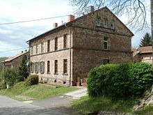
A settlement next to the mine to accommodate miners and officials developed from the 1870s. Bedroom I was completed in 1875 ; a two-storey building with a floor area of 70 by 19 meters, a sandstone facade and a central projecting that emphasized the symmetry of the building , which offered accommodation for 250 people from Saarbrücken. The building, which was built for around 250,000 marks , is the prototype of the “representative sleeping barracks”, which was built in a similar form on other Saar pits. A second sleeping house for 288 miners was built between 1886 and 1890.
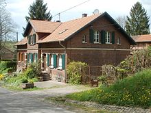
Between 1870 and 1905, a civil servants' settlement was built on the eastern slope of the Burbach valley, which with its different house types reflects the hierarchy of the mine officials: the mine director had a villa in the middle of a park-like complex since 1905 . Massive, two-story sandstone buildings for two families were reserved for Obersteigern . Single-storey houses made of red bricks were built for simple civil servants, which stood out in their furnishings from the premium houses of the miners 'colonies, but like the workers' houses had an economic building that made it possible to keep farm animals.
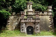
A consumer association was founded in 1868 to provide for the workers who stayed overnight in the mine . Since 1876, a "officials casino" with a bar, reading and billiard room had been set up in bedroom I. There was also a bowling alley, a small music pavilion for Sunday concerts and a so-called beer cellar. The architecture of the entrance to the beer cellar is based on a tunnel mouth hole and is counted among the “most richly designed in German mining”.
In 1905 the settlement, including the dormitory residents, had 595 residents; for which a bathing establishment was available from 1906. The overland tram , which opened in 1907, went back from St. Johann via Riegelsberg to Heusweiler , also on the initiative of the mine director in Von der Heydt . A stop at Heinrichshaus, about 800 meters east of the mine, made it easier for miners from the Köllertal to get to work.
During the League of Nations -Mandats over the Saar (1920-1935) was one in the settlement Domanialschule .
Reuse
After the mine was closed in 1932, an excursion restaurant with a beer garden was established in the former officials' casino, which lasted until the 1980s. From 1939 the settlement belonged to the newly formed community Riegelsberg. After the transfer of power to the National Socialists in 1933, the sleeping houses were a camp for refugees from the German Reich until the Saar area was annexed to Germany in 1935. The camp was run by the Saarland Peace Society and the League for Human Rights in the Saar region and served emigrants as a transit camp on their way to France . Heinrich and Marta Rodenstein lived here in 1933/1934 before going into French exile in January 1935.
After 1935 a "cadre school" was housed in the dormitories. During the Second World War , the dormitories were used as camps for Eastern workers who had to do forced labor in the surrounding pits . Some of the forced laborers as well as some children born in the camp died; they were buried in Riegelsberg.
Saarbergwerke's plans to expand the settlement failed in 1968 because there were fears of damage to the mountains , inadequate sewage disposal and an unfavorable climate in the narrow valley. In 1969 sleeping house II was partially demolished; One wing of the building has been preserved and has housed a Catholic chapel since 1923 . With the territorial and administrative reform in Saarland in 1974 , Von der Heydt came from the community of Riegelsberg (district Güchenbach) to the state capital Saarbrücken (district Malstatt-Burbach) and forms the district 244 in the district of Burbach . The district has an area of 455 hectares (4.55 km²); 89.2% of it is forest.
A sale of the settlement to the city of Saarbrücken, which the Saarbergwerke wanted to sell, did not materialize. In the second half of the 1970s, housing developments on the western side of the valley were demolished; the number of residents fell from 288 (1970) to 100 (1988) to 73 (November 2008). The planned abandonment of the entire settlement led to protests by residents, as a result of which Von der Heydt was placed under monument protection in 1985. According to the State Monuments Office , it is a "[important], authentically preserved mining settlement consisting of dormitories and tenement houses including the associated outbuildings"; The entrance to the beer cellar is particularly emphasized. The dormitories are currently used by the Saarland State Office for Cadastre, Surveying and Mapping and the SaarForst State Office.
Individual evidence
- ↑ a b c Von der Heydt, mine and settlement in the Saarkohlenwald internet history book (menu item: “What happened where, Von der Heydt”, accessed on July 12, 2010).
- ↑ a b Delf Slotta: Mine and settlement Von der Heydt. Insights into the life of miners in the 19th century. ( Page no longer available , search in web archives ) Info: The link was automatically marked as defective. Please check the link according to the instructions and then remove this notice. (Accessed November 21, 2012)
- ↑ Gerhild Krebs: Former mine Von der Heydt at “Memotransfront - Stlaces cross-border memory” (accessed on July 12, 2010).
- ^ Rainer Slotta: winding tower and miner's house. From mining on the Saar. (= Publications from the German Mining Museum Bochum, 17), Saarbrücker Druckerei und Verlag, Saarbrücken 1979, ISBN 3-921646-18-9 , p. 119.
- ^ Burbach - von der Heydt - AW Burbach: Reminiscence of an ignored branch line at www.schrankenposten.de (accessed on July 13, 2010).
- ↑ Bergmannspfad Riegelsberg – Von der Heydt, Grube und Siedlung in the Internet history book Saarkohlenwald (menu item: What happened where, Bergmannspfad, accessed on July 13, 2010).
- ↑ Report of January 19, 1854, quoted by Serwe: These people go to their homes on Saturday ..., p. 51.
- ↑ For the architecture see Serwe: These people go to their homes on Saturday ..., p. 53; Delf Slotta: Von der Heydt mine and settlement. Insights into the life of miners in the 19th century ( page no longer available , search in web archives ) Info: The link was automatically marked as defective. Please check the link according to the instructions and then remove this notice. (accessed November 21, 2012).
- ↑ Serwe: These people go to their homes on Saturday ..., p. 54; Delf Slotta: Von der Heydt mine and settlement. Insights into the life of miners in the 19th century ( memento of the original from June 17, 2007 in the Internet Archive ) Info: The archive link has been inserted automatically and has not yet been checked. Please check the original and archive link according to the instructions and then remove this notice. (accessed on July 13, 2010).
- ↑ This assessment by Delf Slotta: Grube und Siedlung Von der Heydt. Insights into the life of miners in the 19th century ( memento of the original from June 17, 2007 in the Internet Archive ) Info: The archive link has been inserted automatically and has not yet been checked. Please check the original and archive link according to the instructions and then remove this notice. (accessed on July 13, 2010).
- ↑ Tram Saarbrücken - Riegelsberg / Heusweiler in the Internet history book Saarkohlenwald (menu item: What happened where, tram, accessed on July 13, 2010).
- ↑ Arnold Ilgemann: "French schools". The French domain schools during the League of Nations , lecture manuscript from June 22, 1993
- ↑ Bernhild Vögel: Dismissed, persecuted, returned - socialist teachers from the state of Braunschweig between the Weimar Republic and the post-war period , in: Frank Ehrhardt (Heraqus donor on behalf of the Other History Working Group): Paths of life under dictatorship. Contributions to the history of Braunschweig under National Socialism , Appelhans Verlag, Braunschweig, 2007, ISBN 978-3-937664-59-0 , p. 80
- ↑ Gerhild Krebs: Settlement of the Von der Heydt mine in “Memotransfront - Places of cross-border memory” (accessed on June 13, 2010).
- ↑ a b City of Saarbrücken: District dossier 24 - Burbach ( page no longer available , search in web archives ) Info: The link was automatically marked as defective. Please check the link according to the instructions and then remove this notice. (accessed November 21, 2012).
- ↑ Monuments of the coal mining industry in Saarland. Locations and development (PDF, 1.4 MB), p. 27.
literature
- Karl Heinz Janson: Von der Heydt. A former part of Riegelsberg in the forest . Association for Industrial Culture and History eV, Riegelsberg 2017.
- Hans-Jürgen Serwe: "These people go to their homes on Saturday ..." Miners' life in Von der Heydt. In: Klaus-Michael Mallmann (Ed.): We were never really at home. Voyages of discovery in the Saar region 1815–1955. 2nd edition, JHWDietz successor, Berlin 1988, ISBN 3-8012-0124-4 , pp. 50-55.
- Delf Slotta: The Saarland coal mining industry. Publisher: RAG Aktiengesellschaft (Herne) and Institute for Regional Studies in Saarland e. V. (Schiffweiler), Krüger Printing and Publishing, Dillingen / Saar 2011, ISBN 978-3-00-035206-5 .
- Literature on Von der Heydt (Saarbrücken) in the Saarland Bibliography
Web links
- Von der Heydt, Grube and Siedlung at the Internet history book Saarkohlenwald
- Delf Slotta: Von der Heydt mine and settlement. Insights into the life of miners in the 19th century.
- Gerhild Krebs: Settlement of the Von der Heydt mine in “Memotransfront - Places of cross-border memory”.
- Gerhild Krebs: Former Von der Heydt mine at “Memotransfront - Sites of Cross-Border Remembrance”.
Coordinates: 49 ° 16 ′ 33 ″ N , 6 ° 57 ′ 10 ″ E


