Weyregg am Attersee
|
Weyregg am Attersee
|
||
|---|---|---|
| coat of arms | Austria map | |
|
|
||
| Basic data | ||
| Country: | Austria | |
| State : | Upper Austria | |
| Political District : | Vöcklabruck | |
| License plate : | VB | |
| Surface: | 54.62 km² | |
| Coordinates : | 47 ° 54 ' N , 13 ° 34' E | |
| Height : | 482 m above sea level A. | |
| Residents : | 1,562 (January 1, 2020) | |
| Population density : | 29 inhabitants per km² | |
| Postal code : | 4852 | |
| Area code : | 07664 | |
| Community code : | 4 17 49 | |
| NUTS region | AT315 | |
| Address of the municipal administration: |
Weyregger Str. 69 4852 Weyregg am Attersee |
|
| Website: | ||
| politics | ||
| Mayor : | Klaus Gerzer ( SPÖ ) | |
|
Municipal Council : (2015) (19 members) |
||
| Location of Weyregg am Attersee in the Vöcklabruck district | ||
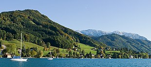
 Weyregg, seen from the Wachtberg |
||
| Source: Municipal data from Statistics Austria | ||
Weyregg am Attersee is a municipality in Upper Austria in the Vöcklabruck district in the Hausruckviertel with 1562 inhabitants (as of January 1, 2020). The responsible judicial district is Vöcklabruck .
geography
Weyregg am Attersee is located at an altitude of 482 m in the Hausruckviertel on the Attersee . The extension is 9.6 km from north to south and 7.9 km from west to east. The total area is 54.6 km². 61.9% of the area is forested, 15% of the area is used for agriculture.
The municipality includes the following localities (population in brackets as of January 1, 2020):
- Alexenau (50)
- Bach (268)
- Gahberg (77)
- Miglberg (80)
- Richwood (173)
- Seeberg (34)
- Stone wall (86)
- Weyregg am Attersee (794)
The “last virtually unspoilt alluvial cone on the east bank” of the Attersee is protected by the nature conservation authority and the requested construction of a marina with a boat harbor in the bank protection zone is prohibited in 2016.
history
During Roman times there was a luxurious villa rustica in the area of today's Römergasse .
Originally located in the eastern part of the Duchy of Bavaria, the place belonged to the Duchy of Austria since the 12th century. Since 1490 it has been assigned to the Principality of Austria ob der Enns .
During the Napoleonic Wars , the place was occupied several times.
Since 1918 the place belongs to the federal state of Upper Austria. After Austria was " annexed " to the German Reich on March 13, 1938, the place belonged to the Gau Oberdonau . After 1945 the restoration of Upper Austria took place.
Population development
In 1991 the municipality had 1622 inhabitants according to the census, in 2001 it had 1503 inhabitants.
Culture and sights
Sports
Weyregg no longer has its own soccer team. Almost every Weyregger is an enthusiastic skier, and you can practice the sport on the 800 meter high Wachtberg. Weyregg is a popular destination for divers and is the only place on Lake Attersee to have two diving centers.
Economy and Infrastructure
Due to its location in the Attersee holiday region, Weyregg is geared towards tourism; holiday guests are offered sailing, surfing, paragliding, hiking, mountain biking, golf and diving. Most of the workplaces in Weyregg are therefore in the hotel and restaurant sector. In spite of a sharp decline in recent years, full-time and part-time farms take second place. Ten companies are active in the manufacturing sector, and almost 30 in the trade and service sector.
Because in the course of feeding swans , they also increasingly appeared in the presence of bathers on bathing beaches and on sunbathing lawns, a feeding ban was decreed in August 2020 by the municipal council in a section of the bank that also contains the lido.
politics
Mayor is Klaus Gerzer (SPÖ).
coat of arms
Blazon : Split; on the right in blue four silver wavy strips symbolizing the Attersee, on the left in gold a black, fallen ivy leaf, from which two stylized tendrils and in the middle a flower grow. The community colors are blue-yellow-blue.
The coat of arms was selected on the basis of an ideas competition advertised by the municipality of Weyregg and awarded in 1972 by the Upper Austrian provincial government. With the waves, it refers to the location on the Attersee and shows the ivy leaf with tendrils, a motif from the floor mosaic of a Roman villa, which was uncovered in 1971 during road construction.
Web links
- Map in the Digital Upper Austrian Room Information System ( DORIS )
- 41749 - Weyregg am Attersee. Community data, Statistics Austria .
- Further information about the municipality of Weyregg am Attersee can be found on the geo-information system of the federal state of Upper Austria .
Individual evidence
- ↑ Statistics Austria: Population on January 1st, 2020 by locality (area status on January 1st, 2020) , ( CSV )
- ↑ "The Attersee tourism, which was lying on the ground, lost a chance" nachrichten.at, June 5, 2016, accessed October 19, 2016.
- ↑ Roman luxury villa with lake view: excavations in Weyregg am Attersee. In: zamg.ac.at . May 7, 2020, accessed May 23, 2020.
- ↑ Website of the TVB Ferienregion Attersee
- ^ Website of the community
- ↑ Swans fed: woman comments orf.at, August 7, 2020, accessed August 7, 2020.
- ^ Herbert Erich Baumert: The coats of arms of the cities, markets and communities of Upper Austria (3rd supplement) . In: Oberösterreichische Heimatblätter, Heft 1/2, 1973, p. 20, online (PDF; 1.5 MB) in the forum OoeGeschichte.at


