
Yamaguchi Prefecture
|
Yamaguchi-ken 山口 県 |
|
|---|---|
  |
|
| Basic data | |
| Administrative headquarters : | Yamaguchi |
| Region : | Chūgoku |
| Main island : | Honshu |
| Area : | 6,112.53 km² |
| Water content: | 2.6 % |
| Residents : | 1,355,495 (October 1, 2019) |
| Population density : | 222 inhabitants per km² |
| Counties : | 4th |
| Municipalities : | 19th |
| ISO 3166-2 : | JP-35 |
| Governor : | Tsugumasa Muraoka |
| Website: | www.pref.yamaguchi.jp |
| Symbols | |
| Prefecture flag : |
 |
| Prefecture tree : | Japanese red pine |
| Prefecture flower : | Citrus natsudaidai |
| Vogel prefecture : | Black crane |
| Fish prefecture : | Puffer fish |
| Prefecture mammal : | Cervus nippon centralis |
| Prefecture song : |
Yamguchi-kenmin no uta ("Song of the Citizens of Yamaguchi") |
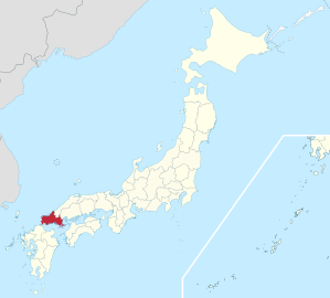
The Yamaguchi Prefecture ( Jap. 山口県 , Yamaguchi-ken ) is a prefecture in Japan . It is located in the Chūgoku region on the island of Honshū . Its administrative seat is in Yamaguchi .
The main city in Yamaguchi Prefecture is not its small capital, but the Shimonoseki industrial port , which is connected to Kyushu Island by a tunnel, bridge and ferry .
history
The Yamaguchi prefecture was established in 1871 in the course of the abolition of the Han , the feudal fiefdom, from the previous fiefdoms Chōshū or Yamaguchi , Tokuyama , Iwakuni , Chōfu and Kiyosue , which were briefly divided into four prefectures (Yamaguchi, Iwakuni, Toyoura, Kiyosue) were reorganized and then merged. The prefecture thus covers the area of the ancient provinces of Nagato and Suō . The prefecture administration was established in what is now Yamaguchi City.
In 1889, during the modernization of the municipal regulations in the Yamaguchi prefecture, a district-free city (Akamagaseki in today's Shimonoseki), four district cities (Yanaitsu in today's Yanai, Yamaguchi, Hagi and Iwakuni) and over 200 village communities were created.
politics
In the gubernatorial election in February 2018 , incumbent Tsugumasa Muraoka was re-elected for a second term with LDP-Kōmeitō support against a CPJ-SDP-backed challenger. The voter turnout fell compared to the 2014 election (38.8%) to a new record low of 36.49%.
In parliament, the LDP defended its absolute majority in the April 2019 elections with 29 out of 47 seats. However, the LDP MPs, along with some of the independents, are spread across several parliamentary groups.
Like much of the Chūgoku region, Yamaguchi is a "Conservative Kingdom" ( Hoshu Ōkuku ), a stronghold of the LDP. In the national parliament , Yamaguchi is represented by four directly elected members of the House of Representatives . The prefecture elects one representative per election to the Senate .
Currently (as of August 2019) the delegation to the national parliament consists of:
- in the House of Representatives
- for constituency 1 with the city of Yamaguchi: Masahiro Kōmura (LDP, 1st term of office), son and successor of Masahiko Kōmura ,
- for constituency 2 in the east on the border with Hiroshima with the city of Iwakuni: Nobuo Kishi (LDP, 3rd term, previously two in the Senate), a grandson of LDP Chairman / Prime Minister Nobusuke Kishi
- for constituency 3 in the north and west with the city of Ube: Takeo Kawamura (LDP, 10th term of office), former education and science minister, 2017 chairman of the budget committee in the House of Representatives
- for constituency 4 in the far west with Yamaguchi's largest city Shimonoseki: Shinzō Abe (LDP, 9th term), LDP chairman / prime minister and grandson of Nobusuke Kishi
- in the Senate
- until 2022
- Kiyoshi Ejima (LDP; 2nd term), former mayor of Shimonoseki
- by 2025
- Yoshimasa Hayashi (LDP, 5th term), former Minister of Defense, Agriculture and Education
- until 2022
Yamaguchi is the home of the Kishi - Abe - Satō family of politicians , in the old electoral law for the House of Representatives from the post-war period until 1996, members of the Abe branch of the family represented the four-mandate 1st constituency of Yamaguchi the western part of the prefecture, Satōs and Kishis the five-mandate 2nd constituency in Eastern part. Another prime minister from the prefecture was Tanaka Giichi , whose son Tatsuo became the first elected governor of Yamaguchi in 1947 and later represented the 1st constituency.
Administrative division
After the prefectures were divided into today's municipal forms in 1889, the Yamaguchi prefecture consisted of one urban district and 12 districts (with 4 small towns and 224 villages). Through incorporations and mergers, the number of municipalities fell from 226 (1920) through 173 (1950) to 70 in 1955. Since 2010, the prefecture has been divided into 13 independent cities (Shi) and 6 small towns (Chō). Of the 4 remaining districts (Gun), three consist of only one municipality each. Since 2005 the largest city Shimonoseki is a "core city" ( chūkakushi ).
As the last village in the prefecture, Hongō was incorporated into the city of Iwakuni in March 2006.
In the table below, the districts ( 郡 , gun ) are shown in italics, below each (indented) the small towns ( 町 , chō ) within. A dependency between rural district and small town can also be seen in the first three digits of the code (1st column). At the beginning of the table are the independent cities ( 市 , shi ).
| code | Surname | Area (in km²) | population | Population density (inh / km²) |
||
|---|---|---|---|---|---|---|
| Rōmaji | Kanji | October 1, 2017 1 | October 1, 2019 3 | October 1, 2015 2 | ||
| 35201 | Shimonoseki- shi | 下 関 市 | 716.10 | 259.855 | 268,517 | 374.97 |
| 35202 | Ube- shi | 宇 部 市 | 286.65 | 165,522 | 169,429 | 591.07 |
| 35203 | Yamaguchi- shi | 山口 市 | 1023.23 | 195,600 | 197,422 | 192.94 |
| 35204 | Hagi- shi | 萩 市 | 698.31 | 46,606 | 49,560 | 70.97 |
| 35206 | Hofu- shi | 防 府 市 | 189.37 | 114,601 | 115,942 | 612.25 |
| 35207 | Kudamatsu- shi | 下 松 市 | 89.35 | 56,550 | 55,812 | 624.64 |
| 35208 | Iwakuni- shi | 岩 国 市 | 873.72 | 132.172 | 136,757 | 156.52 |
| 35210 | Hikari- shi | 光 市 | 92.13 | 50.143 | 51,369 | 557.57 |
| 35211 | Nagato- shi | 長 門市 | 357.31 | 33,570 | 35,439 | 99.18 |
| 35212 | Yanai- shi | 柳 井 市 | 140.05 | 31,598 | 32,945 | 235.24 |
| 35213 | Mine- shi | 美 祢 市 | 472.64 | 24,619 | 26,159 | 55.35 |
| 35215 | Shunan -shi | 周 南市 | 656.29 | 141,225 | 144,842 | 220.70 |
| 35216 | Sanyo-Onoda shi | 山陽 小野 田 市 | 133.09 | 61,434 | 62,671 | 470.89 |
| 35300 | Ōshima-gun | 大 島 郡 | 138.09 | 15,890 | 17.199 | 124.55 |
| 35305 | Suōoshima-chō | 周 防 大 島 町 | 138.09 | 15,890 | 17.199 | 124.55 |
| 35320 | Kuga gun | 玖 珂 郡 | 10.58 | 6309 | 6285 | 594.05 |
| 35321 | Waki-cho | 和 木 町 | 10.58 | 6309 | 6285 | 594.05 |
| 35340 | Kumage gun | 熊 毛 郡 | 119.70 | 29,617 | 30,918 | 258.30 |
| 35341 | Kaminoseki-chō | 上 関 町 | 34.69 | 2482 | 2803 | 80.80 |
| 35343 | Taboo-chō | 田 布施 町 | 50.42 | 14,941 | 15,317 | 303.79 |
| 35344 | Hirao-cho | 平生 町 | 34.59 | 12,194 | 12,798 | 369.99 |
| 35500 | Abu-gun | 阿 武 郡 | 115.95 | 3184 | 3463 | 29.87 |
| 35502 | Abu-cho | 阿 武 町 | 115.95 | 3184 | 3463 | 29.87 |
| Shi-bu ( All shi , part of urban districts) | 市 部 | 5,728.22 | 1,313,495 | 1,346,864 | 235.13 | |
| Gun-bu ( All gun , proportion of counties) | 郡 部 | 384.31 | 55,000 | 57,865 | 150.57 | |
| 35000 | Yamaguchi-ken (Yamaguchi Prefecture) | 山口 県 | 6,112.53 | 1,368,495 | 1,404,729 | 229.81 |
swell
1 Area data from 2017
2 Results of the 2015 census
3 Estimated population 2018
Biggest places
| Census year | Residents | |||
|---|---|---|---|---|
| 2015 | 2010 | 2005 | 2000 | |
| Shimonoseki | 268,517 | 280,947 | 290,693 | 252,389 |
| Yamaguchi | 197,422 | 196.628 | 191,677 | 140,447 |
| Ube | 169,429 | 173.772 | 178.955 | 174,416 |
| Shunan | 144,842 | 149,487 | 152.387 | —— |
| Iwakuni | 136,757 | 143.857 | 103.507 | 105,762 |
| Hofu | 115,942 | 116,611 | 116,818 | 117,724 |
| San'yō-Onoda | 62,671 | 64,550 | 66,261 | —— |
| Kudamatsu | 55,812 | 55.012 | 53.509 | 53.101 |
| Hikari | 51,369 | 53.004 | 53,971 | 46,422 |
| Hagi | 49,560 | 53,747 | 57,990 | 46.004 |
| Nagato | 35,439 | 38,349 | 41,127 | 24.092 |
| Yanai | 32,945 | 34,730 | 35,927 | 33,597 |
| mine | 26,159 | 28,630 | 17,754 | 18,638 |
| Tokuyama | —— | —— | —— | 104,672 |
| Onoda | —— | —— | —— | 45,085 |
| Shinnan'yō | —— | —— | —— | 32,153 |
April 21, 2003 - The cities of Tokuyama and Shinnan'yō as well as two other communities merge to form the new independent city Shūnan .
March 22, 2005 - The city of Onoda and the municipality of San'yō-chō merge to form the new independent city of San'yō-Onoda .
Population development in the prefecture
| Census year |
Total population |
male population |
female population |
Gender ratio men to 1000 women |
Area in km 2 |
Population density per km 2 |
|---|---|---|---|---|---|---|
| 1920 | 1,041,013 | 521.041 | 519.972 | 1002 | 6082.11 | 171.2 |
| 1925 | 1,094,544 | 552.793 | 541.751 | 1020 | 6082.11 | 180.0 |
| 1930 | 1,135,637 | 571,642 | 563.995 | 1014 | 6082.11 | 186.7 |
| 1935 | 1,190,542 | 598.434 | 592.108 | 1011 | 6082.11 | 195.7 |
| 1940 | 1,294,242 | 658.265 | 635.977 | 1035 | 6082.11 | 212.8 |
| 1945 | 1,356,491 | 638.167 | 718.324 | 888 | 6082.11 | 223.0 |
| 1950 | 1,540,882 | 760.220 | 780.662 | 974 | 6098.11 | 252.7 |
| 1955 | 1,609,839 | 792,546 | 817.293 | 970 | 6073.10 | 265.1 |
| 1960 | 1,602,207 | 780.439 | 821,768 | 950 | 6073.10 | 263.8 |
| 1965 | 1,543,573 | 740.934 | 802.639 | 923 | 6079.43 | 253.9 |
| 1970 | 1,511,448 | 719.147 | 792.301 | 908 | 6084.85 | 248.4 |
| 1975 | 1,555,218 | 743.833 | 811.385 | 917 | 6095.45 | 255.1 |
| 1980 | 1,587,079 | 759.255 | 827.824 | 917 | 6101.18 | 260.1 |
| 1985 | 1,601,627 | 763,803 | 837.824 | 912 | 6106.05 | 262.3 |
| 1990 | 1,572,616 | 744.844 | 827.772 | 900 | 6109.09 | 257.4 |
| 1995 | 1,555,543 | 736,555 | 818.988 | 899 | 6110.08 | 254.6 |
| 2000 | 1,527,964 | 722.683 | 805.281 | 897 | 6110.45 | 250.1 |
| 2005 | 1,492,606 | 703.721 | 788.885 | 892 | 6111.91 | 244.2 |
| 2010 | 1,451,338 | 684.176 | 767.162 | 892 | 6113.95 | 237.4 |
| 2015 | 1,404,729 | 665.008 | 739.721 | 899 | 6112.30 | 229.8 |
Famous Products
Hagi pottery comes from Yamaguchi Prefecture and is characterized by a light craquele glaze with an often reddish color. A notch cut into the base is typical of Hagi pottery. Mainly tea bowls and teapots are offered.
Web links
Individual evidence
- ↑ Yamaguchi Prefectural Parliament : Members by political group , accessed August 12, 2019.
- ↑ 現 職 の 村 岡 嗣 政 氏 が 大 差 で 再 選 . In: Mainichi Shimbun . February 5, 2018, Retrieved April 3, 2018 (Japanese).
- ↑ 山口 知事 選 、 現 職 の 村 岡 嗣 政 氏 が 再 選 . In: Yomiuri Online . February 5, 2018, Retrieved April 3, 2018 (Japanese).
- ↑ 統一 地方 選 2019 山口 県 議 選 各 党 議席 . In: NHK Senkyo Web. April 8, 2019. Retrieved August 12, 2019 (Japanese).
- ↑ Kokudo Chiriin (GSI - Geospatial Information Authority of Japan), 平 成 29 年 全国 都 道 府 県 市区 町 村 別 面積 調 (Nationwide survey of all prefectures and municipalities 2017) , p. 81: 35 Yamaguchi-ken (Japanese), accessed on 16 January 2019
- ↑ e-stat (English), accessed on January 16, 2019
- ↑ 簡 単 検 索 ・ 詳細 検 索 ・ 検 索 サ ン プ ル , accessed January 16, 2019 (Japanese)
- ↑ e-Stat database , accessed on January 16, 2019 (English)
Aichi | Akita | Aomori | Chiba | Ehime | Fukui | Fukuoka | Fukushima | Gifu | Gunma | Hiroshima | Hokkaidō | Hyōgo | Ibaraki | Ishikawa | Iwate | Kagawa | Kagoshima | Kanagawa | Kochi | Kumamoto | Kyoto | Mie | Miyagi | Miyazaki | Nagano | Nagasaki | Nara | Niigata | Ōita | Okayama | Okinawa | Osaka | Saga | Saitama | Shiga | Shimane | Shizuoka | Tochigi | Tokyo | Tokushima | Tottori | Toyama | Wakayama | Yamagata | Yamaguchi | Yamanashi
Coordinates: 34 ° 4 ′ N , 131 ° 30 ′ E