
Overturn
|
Überruhr-Hinsel u. -Holthausen |
|

|
|
| Basic data | |
|---|---|
| surface | 6.72 km² |
| Residents | 15,959 (March 31, 2020) |
| Coordinates | 51 ° 25 '35 " N , 7 ° 4' 44" E |
| height | 94 m |
| Incorporation | Aug 1, 1929 |
| Spatial assignment | |
| Post Code | 45277 |
| District number | 43/44 |
| district | District VIII Essen-Ruhr Peninsula |
| image | |
 Essen-Überruhr-Hinsel over the Ruhr valley, view from the Stadtgarten Steele |
|
| Source: City of Essen statistics | |
Überruhr is a south-eastern part of the city of Essen . It is officially divided into the two districts of Überruhr-Hinsel and Überruhr-Holthausen . Überruhr is located on a peninsula above the Ruhr and originally consisted of peasant communities. Later the picture changed to a coal mine landscape on the Ruhr. After its decline, mostly loose residential developments with the appropriate infrastructure have developed on the peninsula.
Location and infrastructure
location
Überruhr lies on a peninsula of the Ruhr , which forms a river loop open to the southeast at this point. It is divided into two parts, both in terms of administrative structure and topographically: Hinsel in the north, and Holthausen in the south. The districts are separated by a valley in which the Marie-Juchacz-Straße runs.
Hinsel is located on a hill that extends from the level of the surrounding Ruhr (about 50 m above sea level ) to about 100 meters above sea level. NHN rises. The Holthausen site also rises from the Ruhr and Marie-Juchacz-Strasse to around 130 meters above sea level. NHN to then drop off to the southeast towards Burgaltendorf and Byfang .
Überruhr borders in the west on Rellinghausen , in the northwest on Bergerhausen , in the north on Steele and in the east on Horst , each with the Ruhr as a border river. The land border is formed by Burgaltendorf in the southeast and Byfang in the south .
Surname
The name Überruhr comes from the location of the district up on a peninsula of the Ruhr , whereby one can infer the current name in different ways. These Ruhr heights were referred to geographically as Overruhr and Oberruhr . Since the two districts of Holthausen and Hinsel used to belong to what was then Rellinghausen Abbey on the other side of the Ruhr, and you had to cross the Ruhr by ferry, you came from Über der Ruhr .
traffic
In local public transport , Essen-Überruhr is connected to the S9 from Haltern am See to Wuppertal via Bottrop , Essen and Velbert - Langenberg . It stops in Überruhr at the S-Bahn stations Überruhr and Holthausen . The historic Prinz Wilhelm Railway , which connected the cities of Essen in the north and Wuppertal in the south , once operated on this route .
The bus lines SB15, 144, 166, 177, NE4 and NE6 the Ruhr railway also use parts of the district Überruhr.
schools
In the district of Hinsel on Überruhrstrasse, the secondary school Überruhr, which opened in 2002, is the youngest school in the city of Essen. The municipal primary school Hinseler Schule is located in Treibweg. There is also the Essen-Überruhr grammar school with around 1,100 students and opened in 1974. In the district of Holthausen there is a branch of the Realschule in Dellmannsweg, the Johann-Peter-Hebel School as a municipal elementary school on the corner of Dellmannsweg / Klapperstraße and the Catholic Suitbert School in Hinseler Hof 125.
Behind the secondary school Überruhr was the Catholic elementary school Ludwig-Kessing-Schule. The school has not accepted an entry class since the 2007/2008 school year and has ended; the building was then used by the Überruhr secondary school.
various
A large part of the water treatment plants of Stadtwerke Essen and Gelsenwasser AG are located in Überruhr . Around 50 million cubic meters (5 · 10 7 m³ ) of water are pumped there every year.
In 1961, the year after the World Eucharistic Congress in Munich, the Peace Chapel of the Holy Eucharist was built on Mönkhoffstrasse. Every 1st May there is a star-shaped procession from all communities in Überruhr to the Friedenskapelle. The church of St. Suitbert from 1964 is considered the most modern church building in Essen. This modern, experimental reinforced concrete shell construction was designed by the Düsseldorf architect Josef Lehmbrock . It was entered in the list of monuments of the city of Essen in 2019.
To the west and east of Überruhr there are extensive water extraction systems of the city of Essen on the Ruhr.
The Ludwig-Kessing-Park , named after the Bergmann from Überruhr and local poet Ludwig Kessing (1869–1940), provides a panoramic view of the Ruhr Valley .
The sports facilities include the Mentingsbank sports field, the Hinseler Hof sports field, the sports hall on Klapperstraße, the sports hall on Langenberger Straße (belonging to the grammar school) and the district sports facility on Überruhrstraße. Today's football - Bundesliga player Markus Heppke (* 1986, Rot-Weiss Essen ) played in youth for seven years at About stirrer Football club Blau-Gelb Überruhr . The rapper Michael Galla played in the youth department of the SG Überruhr handball club .
One of the largest St. Martin's trains in the Ruhr area traditionally pulls up to 10,000 passengers through Überruhr every year.
photos

Coat of arms of Überruhr

Entrance to the Holteyer harbor

Chapel of Peace of the Holy Eucharist

S-Bahn stop Essen-Überruhr
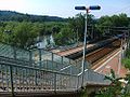
S-Bahn stop at Holthausen

Boathouse on the Ruhr peninsula

Ruhreck with a view of the old Ruhr Bridge Steele , on the right the boathouse


.jpg)
history
Early history
Probably the oldest evidence of settlement in this area was found at the Sonderfeld in Überruhr, which concerns parts of earlier iron processing. Remains of so-called racing furnaces from the younger Iron Age were found in the period from around 800 BC. Until the birth of Christ. In the mid-1960s, when developing the Sonderfeld residential area, west of the Lehmanns Brink street, further findings were made about the settlement of today's Überruhr. These were the remains of a Germanic settlement of the Brukteri from the 2nd and 3rd centuries AD. The finds also include ceramics from the Roman Rhine province. This is how the street Bruktererhang got its name in 1966. This settlement could be identical to the Navalia listed in the Geographike Hyphegesis of Klaudios Ptolemaios .
Hinsel, former farmers and one of the two districts of Überruhr, was first mentioned in a document in 1092 as Hintisle . A document referred to the Hinseler Hof, which later had to give way to the market square and a shopping center. The origin of the name Hinsel is unclear, perhaps it indicates a settlement in a lowland with standing water. In Old Saxon, the ending sel referred to a lowland or stagnant water. The later Springob farm dates from the 18th century and at that time owned around 62 acres of land. In 1834 JA Springob became the owner of this farm. You can also find the spellings Springopshof, Springfeld and Springhoff, so that in 1961 the street Springhoffsfeld in Hinsel got its name. Today there is a large area for drinking water in Hinsel.
Holthausen, the other former farmers and district of Überruhr, was first mentioned in a document in 1054. The name is derived from settlements in holt and indicates the use of the coppice for felling and driving cattle.
Mining
The Ruhr mining industry moved into Überruhr in 1673 with the Mönkhoffsbank colliery in the Wichteltal on the left bank of the Ruhr. Today you can find the remains of a quarry stone shaft building there . The former smithy has been rebuilt and still exists as a residential building. The shaft was later connected to the Holteyer port (a safety port for Ruhr shipping ) and the United Charlotte mine, which was laid out from 1837–1838, by a horse-powered railway . The Heinrich colliery is one of the later facilities.
Larger settlements emerged as a result of the influx of workers for the mining industry around the end of the 17th century. Further development came around 1860 for the United Force colliery , which was the largest and deepest mine in the Ruhr area in the middle of the 19th century. Then there was the Heinrich colliery , whose winding tower is still standing today and where around 3000 people once worked. After a complete shutdown in 1968, mining ended in Überruhr.
Affiliations
The two farmers, Hinsel and Holthausen, belonged to the Rellinghausen Abbey, where the residents had to take a ferry to the church. Most of the people who had overruled were, for example, dependents of the monastery. After the secularization in 1803 the farmers became free and the villages grew due to the immigration of miners. Since 1816 Hinsel and Holthausen belonged to the mayorry of Steele , since 1856 Steele-Land . Within the mayorry of Steele-Land, Hinsel and Holthausen formed the community of Überruhr. Überruhr was raised to its own mayor's office in 1894, where Theodor Heider was the first mayor until 1903. On August 1, 1929, it was incorporated into the city of Essen.
Mayor:
- 1894–1903: Theodor Heider
- 1903–1924: Adolf von Auer
- 1925–1934: Josef Hermanns
coat of arms
Blazon : "In green, a silver (white) overturned corrugated rafter in between, in red, a silver (white) cross-batch or sun wheel with a black eye."
The coat of arms was designed by Kurt Schweder and never had an official character. At the end of the 1980s, the heraldist created coats of arms for all of Essen's districts. They have meanwhile been well received by the Essen population. The coat of arms is a so-called " talking coat of arms "; in documents from the Rellinghausen monastery, the Hinsel and Holthausen farmers were named as "Over Rore" and "Overruhr" at an early stage. The coat of arms indicates this in the form of the wave rafter. The Kreuzschargen is a heraldic sun symbol ; a lucky and disastrous Germanic symbol as a reference to the numerous Germanic soil finds.
Population structure
On March 31, 2020, 15,959 people lived in Überruhr. 7,758 of them lived in Überruhr-Hinsel and 8,201 inhabitants in Überruhr-Holthausen.
Hinsel
(As of March 31, 2020)
- Share of the population under 18-year-olds: 13.4% (Essen average: 16.2%)
- Proportion of the population of at least 65-year-olds: 31.0% (Essen average: 21.5%)
- Proportion of foreigners: 5.6% (Essen average: 16.9%)
Holthausen
(As of March 31, 2020)
- Share of the population under 18 years of age: 15.1% (Essen average: 16.2%)
- Population of at least 65-year-olds: 29.8% (Essen average: 21.5%)
- Proportion of foreigners: 8.9% (Essen average: 16.9%)
Personalities
- Heinrich Bischoff (1904–1964), SS-Unterscharführer and Blockführer in Auschwitz
- Frank Mill (* 1958), football player
literature
- Christian Eiden, Detlef Hopp : Memorable times ... In: Essener contributions. Volume 119, 2006, pp. 353-358.
- Christina Notarius, Heinrich Walgern: Essen-Überruhr - late baroque chimney system of a farmhouse. In: Preservation of monuments in the Rhineland. No. 3, 2001, ISSN 0177-2619 , pp. 114-118.
See also
- List of architectural monuments in Überruhr-Hinsel
- List of architectural monuments in Überruhr-Holthausen
- List of streets in Essen-Überruhr
Web links
Individual evidence
- ^ Ruhrbahn
- ↑ City development process Essen 2015+ - Infrastructure perspective. (PDF) Report of the Infrastructure Project Group. City of Essen, May 2007, accessed on March 10, 2017 : "Überruhrstrasse 115 (Ludwig-Kessing-Schule), for which the Realschule Überruhr will use it after it becomes vacant"
- ↑ Excerpt from the list of monuments of the city of Essen, St. Suitbert ; accessed on January 8, 2020
- ↑ Westdeutsche Allgemeine Zeitung v. October 11, 2008, regional section Essen
- ^ Community encyclopedia for the Kingdom of Prussia 1885
- ↑ See Johann Rainer Busch: Kurt Schweders Wappen der Essener Stadtteile , Essen 2009, p. 93
- ↑ Population figures of the districts
- ↑ Proportion of the population under 18 years of age
- ↑ Proportion of the population aged 65 and over
- ↑ Proportion of foreigners in the city districts
- ↑ Proportion of the population under 18 years of age
- ↑ Proportion of the population aged 65 and over
- ↑ Proportion of foreigners in the city districts

District I: city center | East Quarter | North Quarter | West Quarter | Südviertel | Southeast Quarter | Huttrop | Frillendorf | District II: Bergerhausen | Rellinghausen | Rüttenscheid | City forest | District III: Altendorf | Frohnhausen | Fulerum | Pigtail | Holsterhausen | Margarethenhöhe | District IV: Condition levels | Bergeborbeck | Bochold | Borbeck-Mitte | Dellwig | Frintrop | Gerschede | Schönebeck | District V: Altenessen | Karnap | Bird home | District VI: Katernberg | Schonnebeck | Stoppenberg | District VII: Freisenbruch | Horst | Kray | Leithe | Steele | District VIII: Burgaltendorf | Byfang | Heisingen | Copper turning | Überruhr | District IX: Bredeney | Fish sheet | Heidhausen | Kettwig | Schuir | Become