Autobahn 7 (Switzerland)
| Autobahn 7 in Switzerland | |||||||||||||||||||||||||||||||||||||||||||

|
|||||||||||||||||||||||||||||||||||||||||||
| map | |||||||||||||||||||||||||||||||||||||||||||
| Basic data | |||||||||||||||||||||||||||||||||||||||||||
| Operator: | Federal Roads Office | ||||||||||||||||||||||||||||||||||||||||||
| Start of the street: |
Winterthur ( 47 ° 32 ′ N , 8 ° 47 ′ E ) |
||||||||||||||||||||||||||||||||||||||||||
| End of the road: |
Kreuzlingen ( 47 ° 40 ′ N , 9 ° 10 ′ E ) |
||||||||||||||||||||||||||||||||||||||||||
| Overall length: | approx. 35 km | ||||||||||||||||||||||||||||||||||||||||||
|
Canton : |
|||||||||||||||||||||||||||||||||||||||||||
|
Course of the road
|
|||||||||||||||||||||||||||||||||||||||||||
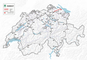
The Swiss Autobahn 7 is congruent with the National Road 7, which leads from Winterthur to Kreuzlingen . The motorway begins at the Winterthur Ost junction, on the A1 . It affects Frauenfeld , the capital of the canton of Thurgau , which is served by a western and an eastern branch. In the Grüneck triangle, the T14 motorway slip road branches off , which is signposted as a motorway as far as Häuser. The last section of the A7 runs underground - through the Girsberg Tunnel, which opened in November 2002 - from Kreuzlingen Süd to Kreuzlingen Nord and then across the state border to the left Rhenish part of Konstanz , where it joins Bundesstrasse 33 on the German side .
Web links
Commons : A7 (Switzerland) - Collection of images, videos and audio files

