
Artannes-sur-Indre
| Artannes-sur-Indre | ||
|---|---|---|
.svg)
|
|
|
| region | Center-Val de Loire | |
| Department | Indre-et-Loire | |
| Arrondissement | Tours | |
| Canton | Monts | |
| Community association | Touraine Vallée de l'Indre | |
| Coordinates | 47 ° 16 ' N , 0 ° 36' E | |
| height | 47-98 m | |
| surface | 20.97 km 2 | |
| Residents | 2,628 (January 1, 2017) | |
| Population density | 125 inhabitants / km 2 | |
| Post Code | 37260 | |
| INSEE code | 37006 | |
| Website | http://artannes.fr/ | |
 Town hall (Mairie) of Artannes-sur-Indre |
||

Artannes-sur-Indre is a French commune with 2,628 inhabitants (as of January 1 2017) in the department of Indre-et-Loire in the region of Center-Val de Loire ; it belongs to the Arrondissement Tours and is part of the canton of Monts (until 2015: canton of Montbazon ). The inhabitants are called Artannais .
geography
Artannes-sur-Indre is located on the Indre River , about 16 kilometers south-southwest of Tours . Artannes-sur-Indre is surrounded by the neighboring communities of Ballan-Miré in the north, Joué-lès-Tours in the northeast, Monts in the east, Thilouze in the south, Pont-de-Ruan in the west and southwest and Druye in the west in the northwest.
Population development
| year | 1962 | 1968 | 1975 | 1982 | 1990 | 1999 | 2006 | 2012 |
| Residents | 654 | 781 | 1,112 | 1,538 | 1,757 | 2,198 | 2,364 | 2,301 |
Attractions
- Saint-Maurice church, foundations from the 12th century, last renovations in the 19th century
- Archbishop's castle, rebuilt in 1470
- Alouette mansion from the 16th century
- Old Turbellière mansion from the 16th century
- Mills Potard and Clausset, mentioned as early as the 13th century
- Old Robinières manor from the 16th century
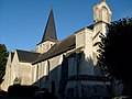
Saint-Maurice Church

Big mill


Community partnerships
Partnerships exist with the Italian municipality of Roccastrada in the province of Grosseto (Tuscany) and with the British municipality of Bathford in Somerset (England) .
literature
- Le Patrimoine des Communes d'Indre-et-Loire. Flohic Editions, Volume 2, Paris 2001, ISBN 2-84234-115-5 , pp. 899-904.