La Ville-aux-Dames
| La Ville-aux-Dames | ||
|---|---|---|

|
|
|
| region | Center-Val de Loire | |
| Department | Indre-et-Loire | |
| Arrondissement | Tours | |
| Canton | Montlouis-sur-Loire | |
| Community association | Touraine Est Vallées | |
| Coordinates | 47 ° 24 ' N , 0 ° 50' E | |
| height | 46-52 m | |
| surface | 8 km 2 | |
| Residents | 5,487 (January 1, 2017) | |
| Population density | 686 inhabitants / km 2 | |
| Post Code | 37700 | |
| INSEE code | 37273 | |
| Website | http://www.ville-aux-dames.com/ | |
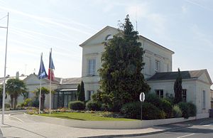
 Ville-aux-Dames town hall |
||
La Ville-aux-Dames is a French commune with 5,487 inhabitants (as of January 1 2017) in the department of Indre-et-Loire in the region of Center-Val de Loire . It belongs to the Arrondissement Tours and the canton of Montlouis-sur-Loire . The residents are called Gynépolitain (e) s .
geography
La Ville-aux-Dames lies between the southern bank of the Loire and the Filet river , a tributary of the Cher . La Ville-aux-Dames is surrounded by the neighboring communities Rochecorbon in the north and northwest, Vouvray in the northeast, Montlouis-sur-Loire in the east, Larçay in the south and Saint-Pierre-des-Corps in the west.
Population development
| year | Residents |
|---|---|
| 1962 | 1,420 |
| 1968 | 1.915 |
| 1975 | 2,479 |
| 1982 | 3,481 |
| 1990 | 4.193 |
| 1999 | 4,647 |
| 2006 | 4,520 |
| 2011 | 5,042 |
Attractions
- Notre-Dame church, originally built in the 11th century, monument historique since 1947
Partnerships
La Ville-aux-Dames has had a partnership with the British community of Dollar in Clackmannanshire (Scotland) since 1981.
literature
- Le Patrimoine des Communes d'Indre-et-Loire. Flohic Editions, Volume 2, Paris 2001, ISBN 2-84234-115-5 , pp. 967-971.
Web links
Commons : La Ville-aux-Dames - Collection of images, videos and audio files
