
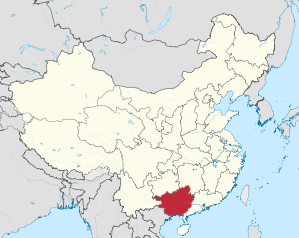
Guangxi
| Abbreviation : 桂 ( Pinyin : Guì) | |
| Capital | Nanning |
|
surface - Total |
Rank 9 out of 33 236,700 km² |
|
population
- Total 2016 |
Rank 11 out of 33
48,380,000 inhabitants |
| Management type | Autonomous area |
| governor | Chen Wu |
 .svg) |
|
| ISO-3166-2 code | CN-GX |
| District level | 14 cities |
| District level | 48 counties, 40 urban districts, 12 autonomous counties, 10 cities |
| Community level | 707 large municipalities, 367 municipalities, 106 street districts, 50 nationality municipalities |
Guangxi ( Chinese 廣西 / 广西 , Pinyin Guǎngxī - "western expanse"; Zhuang Gvangjsih ) has been an autonomous region in the south of the People's Republic of China since 1958 . The full Chinese name is Guǎngxī Zhuàngzú Zìzhìqū 廣西壯族自治區 / 广西壮族自治区 - "Guangxi Autonomous Region of the Zhuang Nationality", the full Zhuang name is Gvangjsih Bouxcuengh Swcigih .
The capital of the autonomous region is Nanning . Other major cities in Guangxi are Guilin , Liuzhou , Wuzhou and Beihai .
geography
In the southwest, Guangxi borders on Vietnam over a length of 1,020 km , and in the west, north and east on the provinces of Yunnan , Guizhou , Hunan and Guangdong .
The climate is subtropical , humid and characterized by the monsoons .
history
As early as the 3rd century BC, the Chinese Qin dynasty claimed the region that had previously belonged to the empire of the non-Chinese Nan-Yue and tried to subdue it. This only succeeded effectively after the following dynasties, but the subjugated minorities in particular rose again and again in uprisings with high losses. In the 19th century, the Jintian uprising broke out in Guangxi .
After the fall of the empire and the collapse of central power, regional warlords ruled the country. The so-called Guangxi clique under Lu Rongting formed an alliance early on with the Kuomintang in the neighboring province of Guangdong . Li Zongren and several younger generals then ruled in Guangxi before submitting themselves to the Kuomintang National Government in 1936. During the Second World War in 1939 the Japanese occupied parts of the province. In 1945 the province fell back to the Kuomintang, which it lost again to the communists in 1949, who finally granted the minorities autonomy.
population
Guangxi is an area inhabited by twelve ethnic groups and is particularly known as the historical settlement area of the Zhuang people . Furthermore, Han (with 63% the largest ethnic group in 2015) Yao , Miao , Dong , Mulam , Maonan , Hui , Gin , Yi , Sui and Gelao also live there . In addition, members of 25 other national minorities are represented here in smaller numbers. In 1958, because of the high proportion of national minorities, Guangxi received the special status of an autonomous region, see also the Autonomous Administrative Units of China .
Population development
Population growth in the province since 1954.
| year | population |
|---|---|
| 1954 census | 19,560,822 |
| 1964 census | 20,845,017 |
| 1982 census | 36.420.960 |
| 1990 census | 42.245.765 |
| 2000 census | 43,854,538 |
| 2010 census | 46,023,761 |
| Guess 2016 | 48,380,000 |
economy
Guangxi is traditionally characterized by agriculture ( sugar cane ), therefore it is one of the poorer provinces of the People's Republic. Guangxi is the largest sugar producer in China.
Industrialization has only recently started . Thanks to the many rivers, the most important branch is the energy industry ( hydropower ). In second place comes the smelting of light metals ( aluminum ) and non-ferrous metals ( copper ), which occur as natural resources .
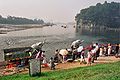
Investments in tourism have increased since the 1990s . The most popular travel destination is the Guilin region with the Li Jiang (Li River) and the impressive karst landscape .
environment
The south of China is repeatedly hit by floods. Most recently in June 2007, roads, businesses and human lives were hit by floods.
Administrative structure
Guangxi is divided into 14 prefecture-level cities :
| Location of cities in Guangxi | # | Surname | chinese name | Pinyin | Zhuang | population
2016 |
|---|---|---|---|---|---|---|

|
||||||
| - District-free city - | ||||||
| 1 | Angry | 百色 市 | Bǎisè Shì | Bwzswz Si | 3,620,200 | |
| 2 | Hey | 河池 市 | Héchí Shì | Hozciz Si | 3,499,000 | |
| 3 | Liuzhou | 柳州市 | Liǔzhōu Shì | Liujcouh Si | 3,958,700 | |
| 4th | Guilin | 桂林市 | Guìlín Shì | Gveilinz Si | 5,009,400 | |
| 5 | Hezhou | 贺州市 | Hezhōu Shì | Hocouh Si | 2,038,700 | |
| 6th | Chongzuo | 崇左 市 | Chóngzuǒ Shì | Cungzcoj Si | 2,069,200 | |
| 7th | Nanning | 南宁 市 | Nánníng Shì | Nanzningz Si | 7,062,200 | |
| 8th | Loaf | 来宾市 | Láibīn Shì | Laizbinh Si | 2,200,500 | |
| 9 | Guigang | 贵港 市 | Guìgǎng Shì | Gveigangj Si | 4,332,000 | |
| 10 | Wuzhou | 梧州 市 | Wuzhōu Shì | Vuzcouh Si | 3,018,400 | |
| 11 | Fangchenggang | 防城港 市 | Fángchénggǎng Shì | Fangzcwngzgangj Si | 929,000 | |
| 12 | Qinzhou | 钦州 市 | Qīnzhōu Shì | Ginhcouh Si | 3,243,000 | |
| 13 | Beihai | 北海 市 | Běihǎi Shì | Bwzhaij Si | 1,643,700 | |
| 14th | Yulin | 玉林 市 | Yùlín Shì | Yilinz Si | 5,756,000 | |
education
Picture gallery
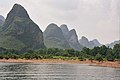
Karst mountains on the Li River
Elephant Trunk Hill on the Li River

Elephant Trunk Hill in Guilin

Zhuang minority


Web links
Individual evidence
- ↑ China: Provinces and Major Cities - Population Statistics, Maps, Charts, Weather, and Web Information. Retrieved May 6, 2018 .
- ↑ Chinese floods leave dozens dead. In: news.bbc.co.uk. June 10, 2007, accessed February 28, 2015 .
- ↑ China: Guăngxī (prefectures, cities, districts and counties) - population figures, graphics and map. Retrieved May 9, 2018 .
Provinces : Anhui | Fujian | Gansu | Guangdong | Guizhou | Hainan | Hebei | Heilongjiang | Henan | Hubei | Hunan | Jiangsu | Jiangxi | Jilin | Liaoning | Qinghai | Shaanxi | Shandong | Shanxi | Sichuan | Yunnan | Zhejiang
Autonomous regions with provincial status : Guangxi | Ningxia | Inner Mongolia | Tibet | Xinjiang
Government immediate cities : Chongqing | Shanghai | Beijing | Tianjin
Special Administrative Areas : Hong Kong | Macau
Claimed but not controlled as a province: Taiwan
Coordinates: 23 ° 48 ' N , 108 ° 59' E