
Biały Bór
| Biały Bór | |||
|---|---|---|---|

|
|
||
| Basic data | |||
| State : | Poland | ||
| Voivodeship : | West Pomerania | ||
| Powiat : | Szczecinek | ||
| Gmina : | Biały Bór | ||
| Area : | 12.82 km² | ||
| Geographic location : | 53 ° 53 ' N , 16 ° 50' E | ||
| Height : | 225 m npm | ||
| Residents : | 2185 (Jun. 30, 2019) |
||
| Postal code : | 78-425 | ||
| Telephone code : | (+48) 94 | ||
| License plate : | ZSZ | ||
| Economy and Transport | |||
| Street : | DK 20 Stargard ↔ Gdynia | ||
| DK 25 Bobolice ↔ Oleśnica | |||
| Rail route : | PKP line 405: Szczecinek – Słupsk | ||
| Next international airport : | Szczecin-Goleniów | ||
| Gmina | |||
| Gminatype: | Urban and rural municipality | ||
| Gmina structure: | 43 localities | ||
| 17 school authorities | |||
| Surface: | 269.93 km² | ||
| Residents: | 5273 (Jun. 30, 2019) |
||
| Population density : | 20 inhabitants / km² | ||
| Community number ( GUS ): | 3215033 | ||
| Administration (as of 2015) | |||
| Mayor : | Paweł Mikołajewski | ||
| Address: | ul. Żymierskiego 10 78-425 Biały Bór |
||
| Website : | www.bialybor.com.pl | ||

Biały Bór ( German Baldenburg ) is a town with a town and country municipality in the Powiat Szczecinecki ( Neustettin ) in the Polish West Pomeranian Voivodeship .
Geographical location
The city is located in the historical West Prussian landscape on the border with Pomerania , on the slope of the Baltic ridge , about thirty kilometers northeast of Szczecinek , on the eastern edge of the Draheimer Seenplatte in the channel between the Labes and the Bölzigsee, which are connected by the Ballfließ, at 182 meters above sea level.
history


The area in which the town of Baldenburg was later founded belonged to the domain of the Princely House of the Samborids in the 12th and 13th centuries . After they died, he came as a result of Pomeranian succession dispute in 1309 to the Teutonic Order and formed part of the Commandery Schlochau the Order state . Christianization was presumably carried out from Poland, which is supported by the long-term ecclesiastical affiliation to the Archdiocese of Gniezno . Presumably there was already a Slavic fishing village near the later town; A nameless village in front of the city is known to us only in documents from 1410 and 1411. In earlier times the village was called Ball de Olde (Polish Bialenburskie ).
Between the Labes and the Bölzigsee an old trade route, coming from the direction of Konitz in the southeast, crossed the lake pass in the direction of the cities Kolberg and Bublitz. The German order initially secured this important transition through a so-called Wildhaus. In the last quarter of the 14th century, the order began to develop the area in the northwest of its Commandery Schlochau. In this context, the town and castle of Baldenburg were laid out. In 1382, Grand Master Konrad Zöllner von Rotenstein gave the city a festival (city privilege). New hand festivals were already issued in 1395 by Grand Master Konrad von Jungingen and in 1408 by Grand Master Ulrich von Jungingen . The hand-held festivals gave the town of Baldenburg town rights according to Kulmer law , assigned the town land and fishing rights and gave it rights to the surrounding forests. The Baldenburg Ordensburg is first mentioned in 1383 as being occupied. It became the seat of a nurse ; the first nurses handed down by name are Ulrich von Lichtenberg (1391) and Heinrich Krischwitz (1397). The village of Bischofthum , located southwest of the city, was assigned as parish property to the pastor of Baldenburg in 1408 by Grand Master Ulrich von Jungingen. In 1408 a great fire raged in the city.
After the Thirteen Years of City War , in the Second Peace of Thorn in 1466 , Baldenburg came from the Teutonic Order State of Prussia to the autonomous Prussian Royal Share , which had voluntarily submitted to the sovereignty of the Polish crown. In 1691 weavers were given special privileges, which led to more settlements from them. As a result, there were 53 cloth makers in Baldenburg in 1624. A school is opened in 1650. Due to the war against Sweden and a plague epidemic around 1710, the upswing of the place stopped. In April 1765 a fire raged in the city and destroyed 74 houses and 20 barns. In 1772, 620 people lived in the city.
With the first division of Poland in 1772, western Prussia and Baldenburg were united with the eastern part of the Kingdom of Prussia under Frederick II of Prussia . From 1818 to 1919 Baldenburg was part of the Schlochau district in the province of West Prussia .
A Catholic church was built in 1875. Three years later the city was connected to the rail network.

Railway station, entrance side

Railway station, back side

Train station, goods shed
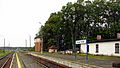
Railway station, platform


Around 1930 the district of Baldenburg had an area of 46.7 km², and there were a total of 361 houses in seven different residential areas in the city area:
- Baldenburg station
- Baldenburg
- recreation
- Gramshof
- Green tree
- Hohenstein
- Fulling Mill
In 1925 there were 2603 inhabitants in the city of Baldenburg, who were distributed over 81 households. Around 1929 there were sand-lime brick and sawmills as well as cooperage in Baldenburg .
After the annexation of most of West Prussia in 1920 after the First World War for the purpose of establishing the Polish Corridor , the Schlochau district with Baldenburg remained with Germany. Baldenburg initially belonged to the Posen-West Prussia border mark formed in 1922 and when it was dissolved in 1938 it became part of the Pomerania Province . In 1939 there were about 2300 people in the city.
During the Second World War , the Wehrmacht was stationed in the village, which later became an important point of defense when the Red Army approached due to its location . As part of the Pommernwall project , defenses were built in and around the village. On January 26, 1945, the place was nevertheless taken by the Red Army . About 80 percent of the place was destroyed.
Soon after the end of the war, Baldenburg, along with West Prussia and Western Pomerania, was placed under Polish administration by the Soviet Union . Then the immigration of Polish and Ukrainian civilians began, initially mainly from areas east of the Curzon Line . The Poles introduced the place name Biały Bór for Baldenburg . In May 1947, the expulsion order for all remaining Germans came. They were driven west from Baldenburg in two transports of 400 people each .
In 1957, 1,315 people lived in Biały Bór, including many Ukrainians of Polish nationality who had been resettled as part of the Vistula action .
Demographics
| year | Residents | Remarks |
|---|---|---|
| 1783 | 815 | including the magistrate mostly Germans and Protestants (few Catholics, six privileged protective Jewish families) |
| 1831 | 1185 | mostly Germans and Protestants |
| 1864 | 2124 | of which 1,949 Evangelicals and 56 Catholics |
| 1871 | 2144 | including 1,940 Evangelicals and 60 Catholics |
| 1875 | 2177 | |
| 1890 | 2237 | including 38 Catholics and 83 Jews |
| 1905 | 2449 | mostly evangelicals |
| 1925 | 2603 | including 81 Catholics and 40 Jews |
| 1933 | 2396 | |
| 1939 | 2294 | , mostly evangelicals |
| 1957 | 1315 |
Attractions
- Neo-Gothic St. Michaels Church from 1878.
- Greek Catholic Church of the Nativity of the Most Holy Virgin Mary , built from 1992 to 1997
- Monument to Taras Shevchenko
traffic
Biały Bór is located at the intersection of the national road 20 from Danzig to Stargard ( Stargard in Pomerania ) with the national road 25 from Bobolice ( Bublitz ) to Bydgoszcz ( Bromberg ) and on to Oleśnica ( Oels ).
There is a connection to the Szczecinek ( Neustettin ) - Słupsk ( Stolp ) railway line .
sons and daughters of the town
- Samuel Friedrich Biegon von Czudnochowski (1789–1864), Prussian politician
- Karl Russ (1833–1899), German specialist author in the field of birds
- Georg Ludwig Rudolf Maercker (1865–1924), German major general in the First World War
- Udo Keller (1941–2012), German entrepreneur and honorary senator of the University of Tübingen
Gmina Biały Bór
General
The urban and rural municipality of Biały Bór covers an area of 270 km² with a population of more than 5000. It is located in the south-east of the West Pomeranian Voivodeship, right on the border with the Pomeranian Voivodeship .
In the north of the municipality, the Burgwallberg rises 239.1 meters as one of the highest Pomeranian mountains.
There are two postcodes in the municipality:
- Drzonowo ( Schönau ) = 78-421
- Biały Bór = 78-425.
In addition to the railway station in Biały Bór, there is also the Drzonowo railway station in the municipality, both of which are located on the state railway line 405 Piła ( Schneidemühl ) - Ustka ( Stolpmünde ) .
Neighboring municipalities of Gmina Biały Bór are:
- in the West Pomeranian Voivodeship:
- Szczecinek ( Neustettin ) in the Powiat Szczecinecki ( Neustettin district )
- Bobolice ( Bublitz ) and Polanów ( Pollnow ) in the Powiat Koszaliński ( Köslin District )
- in the Pomeranian Voivodeship:
- Miastko ( Rummelsburg ) in the Powiat Bytowski ( Bütow district )
- Koczała ( Flute Stone ) and Rzeczenica ( Stegers ) in the powiat Człuchowski ( Schlochau district ).
Community structure
The Gmina Biały Bór is divided into 17 districts with a Schulzenamt ( sołectwo in Polish ) in 43 localities in total:
- Districts :
|
|
- Other localities :
- Bagniewko ( Rohrhof ), Białka ( Klein Wittfelde ), Biskupice-Kolonia, Błogowo, Borzęcino ( Borntin ), Cieszęcino, Cybulin ( Neuhof ), Dalkowo ( Wiesenberg ), Dołgie ( Dolgen ), Domaradz, Donimierz ( Petersberg ), Jawory ( Fluß ) , Kamienna ( Hohenstein ) Kierzkowo, Kolesnik ( Pulvermühl ) Kosobudy, Linowo ( Linow ) Lubisz ( Lubschendorf ) Milkovo ( Miele Kamp ), Miłobądz ( Karlshof ) Ponikwa ( Steinberg ), Radzewo, Rosłonki ( Rosenhof ) Rzyszczewko ( Ristenkaten ), Stepno and Zduny.
Partner communities
There is a partnership with the joint municipality of Salzhausen in Lower Saxony .
literature
- Johann Friedrich Goldbeck : Complete topography of the Kingdom of Prussia . Part II: Topography of West Prussia , Marienwerder 1789, pp. 72–73, No. 4.) ( online )
- August Eduard Preuss : Prussian country and folklore or description of Prussia . Bornträger Brothers, Königsberg 1835, pp. 380–381, no. 13 .
- Manfred Vollack, Heinrich Lemke: The Schlochau district - a book from Prussian-Pomeranian homeland . Kiel 1974, ISBN 3-9800051-1-9 .
- Hans Jakob Schmitz: The city of Baldenburg and its history . Schneidemühl 1932, DNB 365685755 .
- August Blanke: From the past days of the Schlochau district . Schlochau 1936, OCLC 177382843 , pp. 11-14.
- Johannes Hinz: Pomerania. Signpost through an unforgettable country. Bechtermünz, Augsburg 1996, ISBN 3-86047-181-3 .
- Wolfgang Kessler: On the history of Baldenburg, a small town on the border between Pomerania and West Prussia. Martin Opitz Library, Herne 2008, ISBN 978-3-923371-32-7 .
Web links
- Detailed history article in the home district of Schlochau
- Photographs from Baldenburg 1935
- Drawn city map of Baldenburg from 1810 (PDF; 8.5 MB)
- Gunthard Stübs and Pomeranian Research Association: The town of Baldenburg in the former Schlochau district in Pomerania (2011).
- Website of the Jewish Community in Biały Bór (English)
Individual evidence
- ↑ a b population. Size and Structure by Territorial Division. As of June 30, 2019. Główny Urząd Statystyczny (GUS) (PDF files; 0.99 MiB), accessed December 24, 2019 .
- ^ Website of the city, Władze Miasta , accessed on January 21, 2015
- ↑ a b August Eduard Preuss: Prussian country and folklore . Königsberg 1835, pp. 380–381, no. 13.
- ^ A b Ernst Bahr: Baldenburg . In: Handbook of historical sites, East and West Prussia , Kröner, Stuttgart 1981, ISBN 3-520-31701-X , pp. 7–8.
- ↑ a b c Gunthard Stübs and Pomeranian Research Association: The city of Baldenburg in the former Schlochau district in Pomerania (2011).
- ↑ The Big Brockhaus . 5th edition, Volume 2, Leipzig 1929, p. 241.
- ↑ Manfred Vollack, Heinrich Lemke: The Schlochau district - A book from the Prussian-Pomeranian homeland . Kiel 1974, ISBN 3-9800051-1-9 , p. 301.
- ^ Johann Friedrich Goldbeck : Complete topography of the Kingdom of Prussia . Part II: Topography of West Prussia , Marienwerder 1789, pp. 72–73, no. 4.)
- ^ E. Jacobson: Topographical-statistical manual for the administrative district Marienwerder , Danzig 1868, pp. 126–127, No. 9 .
- ^ Gustav Neumann: Geography of the Prussian State . 2nd edition, Volume 2, Berlin 1874, pp. 55–56, item 11.
- ^ A b c d Michael Rademacher: German administrative history from the unification of the empire in 1871 to the reunification in 1990. Pomerania - Schlochau district. (Online material for the dissertation, Osnabrück 2006).
- ^ Meyers Konversations-Lexikon . 6th edition. Second volume, Leipzig and Vienna 1906, p. 297.
- ↑ http://bip.bialybor.com.pl/
- ↑ Entry about the partner community Biaɫy Bór on the homepage of the joint community Salzhausen.Retrieved on April 24, 2019, 10:59

Cities: Barwice (Bärwalde) | Biały Bór (Baldenburg) | Borne Sulinowo (Groß Born) | Szczecinek (Neustettin)
Rural communes : Grzmiąca (Gramenz) | Szczecinek (Neustettin-Land)