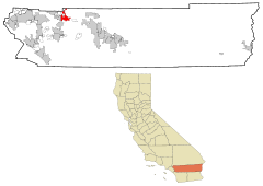
Banning (California)
| Banning | |
|---|---|
 Ring of Honor |
|
| Location in California | |
| Basic data | |
| Foundation : | 1913 |
| State : | United States |
| State : | California |
| County : | Riverside County |
| Coordinates : | 33 ° 56 ′ N , 116 ° 53 ′ W |
| Time zone : | Pacific ( UTC − 8 / −7 ) |
| Residents : | 29,603 (as of 2010) |
| Population density : | 494.8 inhabitants per km 2 |
| Area : | 59.826 km 2 (approx. 23 mi 2 ) of which 59.826 km 2 (approx. 23 mi 2 ) are land |
| Height : | 716 m |
| Postal code : | 92220 |
| Area code : | +1 951 |
| FIPS : | 06-03820 |
| GNIS ID : | 1660306 |
| Website : | www.ci.banning.ca.us |
| Mayor : | Kind of what |
Banning is a city in Riverside County in the US state of California . It has 29,603 inhabitants (as of 2010) and is named after the stagecoach owner Phineas Banning , who is also known as the "father of the Port of Los Angeles ". Banning is located in the San Gorgonio Pass , which is also often called the Banning Pass .
Banning shares many geographic and regional similarities with its western neighbor, Beaumont . Both cities have seen significant population growth since the 1990s. They are on a motorway and a railway line.
Banning's motto is "Proud History, Prosperous Tomorrow" ( German: proud past, rich future).
geography
Banning is located in the north of Riverside County in the US state of California and borders in the north on San Bernardino County . Adjacent places are Beaumont in the west and Cherry Valley in the northwest, otherwise the city is surrounded by unincorporated territory. Banning is connected to the road network via Interstate 10 , which runs through the southern part of the city.
Banning has 29,603 inhabitants ( 2010 census ) and covers an area of 59.826 km², which is made up entirely of land; the population density is thus 494.8 inhabitants per square kilometer and is comparatively low. The center of Banning is at an altitude of 716 m, which is why the climate here is colder than in the only 240 m high County Seat Riverside and in the Coachella Valley in the Colorado desert to the east .
The San Andreas Fault , through which the San Gorgonio Pass was formed, also runs through Banning.
Banning is about 40 km west of Palm Springs and 160 km east of Los Angeles .
history
Banning was inhabited by the Cahuilla Indians until the mid-19th century , although the area originally belonged to the Serrano until the Cahuilla added the San Gorgonio Pass to their land. In 1824 this area became part of the San Gabriel Arcángel Mission , and later it belonged to Rancho San Jacinto y San Gorgonio . The first English settler was Isaac Smith in 1853. The number of the Cahuilla declined a few years later due to the smallpox epidemic on the Pacific coast of North America in 1862 . In 1877 Indian reservations were created for the indigenous people.
The first stagecoach route reached Banning in 1862, and the town was connected to the railway network in 1876. In addition, US Highway 99 , which no longer exists today, was built in 1923 , California State Route 60 and US Highway 70 in 1936, and later Interstate 10 . The railway line of the Southern Pacific Railroad , which was laid in 1881, was of great importance for Banning's growth . The line was later taken over by the Union Pacific Railroad .
Banning borders the Morongo Indian Reservation, which is inhabited by the Cahuilla Indians. The relationship with the Indians was strained, among other things, by disputes over water rights.
It used to be called Banning Moore City . Ransom B. Moore owned a cattle ranch, settled in the area around present-day Banning and the San Gorgonio Mountains from the late 1850s to the early 1880s, and served on the Los Angeles County Board of Supervisors. The town of Banning was granted town charter on February 6, 1913.
politics
Banning is part of the 23rd district in the California Senate , currently represented by Republican Mike Morrell , and the 42nd district in the California State Assembly , represented by Republican Brian Nestande . Banning is also a member of California's 36th Congressional District , which has a Cook Partisan Voting Index of R + 1 and is represented by Democrat Raul Ruiz .
Web links
- Official site of Banning (English)
- Further information at City-Data.com (English)
Individual evidence
- ↑ a b City limits of Banning, OpenStreetMap
- ↑ Information on Banning at City-Data.com (English)
- ↑ Airports near Banning, California USA Today (English)
- ↑ Around the Capitol, Senate District 23, District Map (English)
- ↑ Around the Capitol, Assembly District 42, District Map (English)
- ↑ Around the Capitol, Congressional District 36, District Map (English)


