Coachella
| Coachella | |
|---|---|
| Nickname : Coachello, La Coachelita, Cochela | |
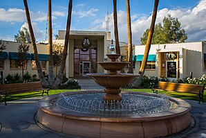
 town hall |
|
| Location in California | |
| Basic data | |
| Foundation : | 1876 |
| State : | United States |
| State : | California |
| County : | Riverside County |
| Coordinates : | 33 ° 41 ′ N , 116 ° 10 ′ W |
| Time zone : | Pacific ( UTC − 8 / −7 ) |
| Residents : | 40,704 (as of 2010) |
| Population density : | 542.9 inhabitants per km 2 |
| Area : | 74.981 km 2 (approx. 29 mi 2 ) of which 74.981 km 2 (approx. 29 mi 2 ) are land |
| Height : | -21 m |
| Postal code : | 92236 |
| Area code : | +1 760 |
| FIPS : | 06-14260 |
| GNIS ID : | 1652686 |
| Website : | www.coachella.org |
| Mayor : | Eduardo Garcia |
Coachella [ koʊˈtʃɛlə or koʊ.əˈtʃɛlə ] is a US city with around 40,704 inhabitants in Riverside County in the US state of California . Coachella is the easternmost town in the Coachella Valley .
Known as the "City of Eternal Sunshine", the place is a rural and agricultural city in the desert. In the late 20th century, Coachella was one of the fastest growing cities in California. The population increased from 1,000 in 1946 to over 40,000 in 2010.
geography
Coachella is located in central Riverside County in California in the USA . It borders the city of Indio to the northwest and the municipality of Thermal to the southeast . The remaining borders are unincorporated.
The city is located in the Coachella Valley in the Colorado Desert , around 16 kilometers from the north shore of the Salton Sea. The distance to Palm Springs is 45 kilometers, the city of Riverside is 116 kilometers west of Coachella. Los Angeles is 130 miles away.
The city is well connected to the long-distance transport network via several motorways . The western urban area is crossed by California State Route 111 , a piece to the east of it runs almost parallel to California State Route 86 , which is identical on this section to California State Route 86S . To the north of the city, mostly outside the densely populated area, Interstate 10 runs along.
Coachella has 40,704 inhabitants (as of the 2010 census ). The city extends over an area of 74.981 km², which consists entirely of land; the population density is thus 542.9 inhabitants per square kilometer. The city center is at a height of −21 meters, with the average height of the urban area being −35 meters.
history
Coachella was founded in 1876 on the route of the Southern Pacific Railroad on a siding as a Woodspur . In the following decade, the local Cahuilla Indians sold their land to the railroad company, and workers settled on the line in the 1890s.
The origin of today's name Coachella is unclear, but it is certain that the citizens of Woodspur voted to change the name of their town in 1901 and at a meeting decided on the name Coachella. Some local residents believe that it is a misspelling of the Spanish word conchilla . This is the name given to the snail shells that were found in the sandy bottom of the valley and testify to a lake that dried up over 3000 years ago.
The young place only comprised a 6.5 km² area, which was further expanded in the grid system . It was not until the 1950s that the city was expanded to its present-day area. Today this is largely covered by farms and orchards, especially with citrus plants or date palms .
In 1946 Coachella was granted city rights and the desert settlement, which had only 1000 inhabitants at the time, became a city . John Westerfield became the first mayor.
By the 1980 census , Coachella was able to increase its population to 10,000. Because of the excessively high proportion of Hispanics in the population, the city became a meeting place for Chicanos who held protests here. In the 1960s and 1970s, the then President of the United Farm Workers , César Chávez , visited the place.
population
Coachella has seen a rapid population increase for several years. In the official survey in 2000, 22,724 inhabitants were counted, at the beginning of 2007 there were already 38,486 inhabitants.
The vast majority of the population, around 97%, belongs to the group of Hispanics , while whites only make up around 1.5% of the population.
politics
Coachella is part of the 28th District in the California Senate , currently represented by Democrat Ted Lieu , and the 56th District of the California State Assembly , represented by Democrat V. Manuel Perez . Coachella is also a member of California's 36th Congressional District , which has a Cook Partisan Voting Index of R + 1 and is represented by Democrat Raul Ruiz .
Web links
- Coachella website (English)
- Chamber of Commerce of Coachella (English)
- Further information at City-Data.com (English)
- Howser, Huell: Coachella - Palm Springs Week (18) California's Gold , Chapman University, Huell Howser Archive (English)
Individual evidence
- ↑ City Council: Mayor Garcia ( Memento of the original from January 12, 2015 in the Internet Archive ) Info: The archive link was inserted automatically and has not yet been checked. Please check the original and archive link according to the instructions and then remove this notice. Coachella Official Website
- ↑ OpenStreetMap
- ↑ Around the Capitol, Senate District 28, District Map (English)
- ↑ Around the Capitol, Assembly District 56, District Map (English)
- ↑ Around the Capitol, Congressional District 36, District Map (English)


