Hemet
| Hemet | |
|---|---|
 town hall |
|
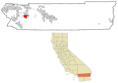
| Location in California | |
| Basic data | |
| Foundation : | 1887 |
| State : | United States |
| State : | California |
| County : | Riverside County |
| Coordinates : | 33 ° 45 ′ N , 116 ° 58 ′ W |
| Time zone : | Pacific ( UTC − 8 / −7 ) |
| Residents : | 78,657 (as of 2010) |
| Population density : | 1,090.6 inhabitants per km 2 |
| Area : | 72.124 km 2 (approx. 28 mi 2 ) of which 72.124 km 2 (approx. 28 mi 2 ) is land |
| Height : | 486 m |
| Postcodes : | 92543-92546 |
| Area code : | +1 951 |
| FIPS : | 06-33182 |
| GNIS ID : | 1652718 |
| Website : | www.cityofhemet.org |
| Mayor : | Robert Youssef |
Hemet is a city in Riverside County in the US state of California with 78,657 inhabitants (as of 2010) and a size of 72.124 km². Together with the neighboring city of San Jacinto , it forms the San Jacinto Valley .
Founded in 1887, Hemet achieved independence status in 1910. At that time, 992 people lived in the city. The construction of the Lake Hemet Reservoir helped the city grow and boosted local agriculture.
Hemet is known for the play The Ramona Pageant . Performed since 1923, it is one of the oldest open air plays in the United States.
According to Robert Vaughn Young Hemet is the actual headquarters of Scientology - sect .
geography
Hemet is located west of Riverside County in California in the United States . Diamond Valley Lake is southwest of the town limits . In the southwest Hemet borders on the town of Winchester , in the east on East Hemet and Valle Vista and in the north on the city of San Jacinto , with which Hemet forms the San Jacinto Valley . This is surrounded by the Santa Rosa Hills and San Jacinto Mountains . Apart from Diamond Valley Lake, it consists of dry land.
Major cities in the area are Riverside 50 km northwest and San Diego 110 km south of Hemet. Of Los Angeles ' downtown Hemet is 130 km away.
Hemet has 78,657 inhabitants (as of 2010) and covers an area of 72.124 km², which consists entirely of land; the population density is 1090.6 inhabitants per square kilometer and is average. The center of Hemet is at an altitude of 486 m.
Infrastructure
Hemet is connected to the road network via California State Routes 74 and 79 . The roads in Hemet are predominantly (engl. In a grid-shaped road network grid ) are arranged.
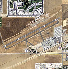
Air traffic is handled by Hemet-Ryan Airport , which is subordinate to Riverside County and not the city itself. It's in Hemet's east. The closest international airports are Palm Springs International Airport and Los Angeles-Ontario Airport .
The railway line to Hemet was operated by the Atchison, Topeka and Santa Fe Railway from 1888 to 1987 . It was used to transport oranges from the region. In 1987 it was almost completely dismantled due to insufficient transport demand. Your leftovers are used today for short-term storage of rail vehicles. According to the city's plans, further parts of the remaining rails are to be removed in order to make intersections between roads and the railway line more level.
climate
| Hemet, California | ||||||||||||||||||||||||||||||||||||||||||||||||
|---|---|---|---|---|---|---|---|---|---|---|---|---|---|---|---|---|---|---|---|---|---|---|---|---|---|---|---|---|---|---|---|---|---|---|---|---|---|---|---|---|---|---|---|---|---|---|---|---|
| Climate diagram | ||||||||||||||||||||||||||||||||||||||||||||||||
| ||||||||||||||||||||||||||||||||||||||||||||||||
|
Average monthly temperatures and rainfall for Hemet, California
Source: www.weathercurrents.com
|
||||||||||||||||||||||||||||||||||||||||||||||||||||||||||||||||||||||||||||||||||||||||||
history
Indians from the Cahuilla tribe were the original inhabitants of the area where Hemet is located today. In the early 18th century, the land was used by the San Luis Rey de Francia mission station for livestock farming and the area was henceforth called Rancho San Jacinto . In 1842 the land fell into the possession of the settler José Antonio Estudillo . During the first great southern California land boom, WF Whittier and EL Mayberry founded the Lake Hemet Water Company , the Hemet Land Company and the town of Hemet in 1887 . In 1895 the construction of the dam was finished and Lake Hemet was completed as a reliable source of water for the San Jacinto Valley . The reservoir was very important for the development of local agriculture. The Indians in the local area were resettled in an Indian reservation near San Jacinto .
In January 1910, Hemet was promoted to an independent city . In an election, 130 citizens voted for and 33 against this act. The opponents were landowners who feared higher taxes in Hemet. As a city, the city could be better protected and the infrastructure strengthened. Located on a railway line to Riverside , Hemet became a hub for agricultural products such as citrus fruits, apricots, peaches, olives and walnuts from the San Jacinto Valley. From 1936 a local agricultural fair took place in Hemet for a long time before it was moved to Perris . In World War II Hemet was the location of the Ryan School of Aeronautics, which trained 6,000 pilots from 1940 to 1944 for the United States Army Air Forces ; their site was later converted to today's Hemet-Ryan Airport .
Large housing estates were built in the 1960s, mostly in the form of retiree settlements with mobile homes , which gave the city the reputation of a “retirement town for the working class”. In the 1980s, more and more single-family houses and large shopping centers were built on former fields. The economic downturn in the early 1990s was followed by ten years of stagnation in development. At the beginning of the new millennium, the number of new houses exploded. The affordable housing, the proximity to employment centers such as Corona , Riverside and San Bernardino as well as the still rural character made Hemet an attractive city for working-class families who could not afford a life in other parts of Southern California.
Timeline
The timeline is taken from the Hemet Library Heritage Room History Collection.
- 1850: California becomes a US state
- 1858: Hemet is established as a farming settlement
- January 27, 1887: Lake Hemet Water Company and Hemet Land Company are founded
- 1888: Rail traffic between Perris and the San Jacinto Valley begins
- 1892: establishment of a post office
- 1893 Riverside County is formed from San Diego Counties and San Bernardino Counties
- 1893: First elementary school
- 1894: First high school
- October 9, 1895: The Lake Hemet Dam is completed
- December 25, 1899: A strong earthquake (estimated strength: approx. 6.5) destroys most of the stone houses
- January 20, 1910: Hemet is the City collected
- 1914: The Santa Fe depot (see photo) is opened
- April 21, 1918: A strong earthquake (estimated strength: approx. 7) leads to structural damage and land breaks
- 1921: The Hemet theater opens
- April 1923: First performance of The Ramona Pageant in Hemet
- August 1940: The Ryan School of Aeronautics opens
- October 3, 1943: The local hospital opens
- September 26, 1950: The Eastern Municipal Water District is created
- July 1, 1966: The unified Hemet Unified School District is formed
- 1970: Hemet has over 10,000 inhabitants for the first time
- September 23, 1972: A new high school opens
- 1980: real estate boom
- 1987: The Santa Fe depot is abandoned and offered for sale to the city of Hemet
- 1987: Bácum in Mexico becomes a twin town
- 1988: The Santa Fe depot is acquired by "Save Our Station" (SOS)
- October 8, 1991: The nearby Domenigoni and Diamond Valley are as a location for the Diamond Valley Lake selected
- 1995: Construction begins on Diamond Valley Lake
- June 13, 1996: "Domenigoni Parkway" opens
- June 1998: The Hemet Museum opens in the former Santa Fe depot
- November 1999: Completion of the Diamond Valley Lake
- March 2000: Diamond Valley Lake opens along with its recreation area
- 2010: Hemet celebrates its centenary as a city
population
Once known as the “retiree stronghold” with an average age of over 64 years, the current age of 39 is steadily falling.
Around 15% of the population are of German descent, which is the highest proportion of the population by descent. Around a quarter of the population is Mexican.
The unemployment rate is 12.9%.
politics
Hemet is part of the 23rd district in the California Senate , currently represented by Republican Mike Morrell , and the 42nd and 67th districts of the California State Assembly , represented by Republicans Brian Nestande and Melissa Melendez . Hemet is also a member of California's 36th Congressional District , which has a Cook Partisan Voting Index of R + 1 and is represented by Democrat Raul Ruiz .
Robert Youssef has been the mayor of Hemet since December 13, 2011.
Personalities
sons and daughters of the town
- James Lafferty (born 1985), actor
- Jeff Hanneman (1964-2013), musician
Personalities associated with Hemet
- Carl Barks (1901–2000), comic strip artist and artist, lived in Hemet from 1942 to 1969
- Jeff Hanneman (1964–2013), American guitarist and co-founder of the thrash metal band Slayer, died here in town
- David Miscavige (* 1960), Scientologist, lives near Hemet
- Bill Murray (born 1950), actor, owned a house in Hemet
Web links
- Official Website of Hemet (English)
- Further information at City-Data.com (English)
- Information about San Jacinto Valley to the Hemet along with San Jacinto belongs (English)
Individual evidence
- ↑ site of Hemet: Mayor (English)
- ↑ Empire of Evil . In: Der Spiegel . No. 39 , 1995 ( online ).
- ↑ Lawrence Wright: The Apostate The New Yorker , February 14, 2011 (English)
- ↑ Information about Hemet at City-Data.com (English)
- ↑ a b OpenStreetMap
- ↑ American Fact Finder Profile of General Population and Housing Characteristics: 2010 (English)
- ↑ Table DP-1. Profile of General Demographic Characteristics: 2000, Geographic Area: Hemet city, California ( Memento of November 25, 2005 in the Internet Archive ) (English; PDF; 40 kB)
- ↑ Unemployment rate Hemet homefacts.com, data from June 2013 (English)
- ↑ Around the Capitol, Senate District 23, District Map (English)
- ↑ Around the Capitol, Assembly District 42, District Map (English)
- ↑ Around the Capitol, Assembly District 67, District Map (English)
- ↑ Around the Capitol, Congressional District 36, District Map (English)
- ↑ The Hemet Years cbarks.dk (English)
- ↑ Bill Murray Divorce Finalized people.com (English)


