Bardo (Powiat Ząbkowicki)
| Bardo | ||
|---|---|---|

|
|
|
| Basic data | ||
| State : | Poland | |
| Voivodeship : | Lower Silesia | |
| Powiat : | Ząbkowice Śląskie | |
| Gmina : | Bardo | |
| Area : | 4.71 km² | |
| Geographic location : | 50 ° 31 ′ N , 16 ° 44 ′ E | |
| Height : | 492 m npm | |
| Residents : | 2562 (June 30, 2019) | |
| Postal code : | 57-256 | |
| Telephone code : | (+48) 74 | |
| License plate : | DZA, DKL | |
| Economy and Transport | ||
| Street : | Kłodzko - Nysa | |
| Rail route : | Kamieniec Ząbkowicki – Kłodzko | |
| Next international airport : | Wroclaw | |
| administration | ||
| Website : | www.bardo.pl | |
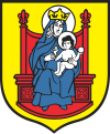
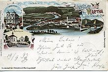
Bardo [ ˈbardɔ ] (also Bardo Śląskie ; German Wartha ) is a town in the powiat Ząbkowicki in the Polish Voivodeship of Lower Silesia . It is the seat of the town-and-country municipality of the same name . It is also one of the most famous Marian pilgrimage sites in Silesia .
Geographical location
The city is located in Lower Silesia on the Wartha pass ( Przełęcz Bardzka ) on the Glatzer Neisse , which enters Silesia from the Glatzer Kessel through the Wartha Mountains ( Góry Bardzkie ), ten kilometers southwest of the district town of Ząbkowice Śląskie ( Frankenstein ).
Neighboring towns are Brzeźnica ( Briesnitz ) in the north, Potworów ( Riegersdorf ) and Przyłęk ( Frankenberg ) in the northeast, Piasek ( Sand ) in the east, Janowiec ( Johnsbach ), Dzbanów ( Banau ), Ożary ( Hemmersdorf ) and Laskówka ( Gierichswalde ) in the southeast, Boguszyn ( Friedrichswartha ) and Dębowina ( Eichau ) in the southwest and Morzyszów ( Morischau ) and Opolnica ( Giersdorf ) in the west. To the southwest is the 459 m high Wachberg ( Strażnik ).
history
The city is located on an old trade and military route that led from Prague via Glatz , Nimptsch and Breslau to Gnesen . It was secured by strong castles and was used by Bishop Otto von Bamberg in 1124 when he moved to Pomerania to Christianize .
The Wartha Castle secured the Wartha pass and the breakthrough of the Glatzer Neisse at the transition from the Glatzer Land to Silesia. It played a special strategic role in the disputes between Bohemia and Poland over supremacy in Silesia that had been going on since the 10th century . In 1096 it was destroyed and taken by the Bohemian Duke Břetislav II and in 1128 it was still in Bohemian possession. In 1155 Wartha was already the seat of a Polish castellan and belonged to the Duchy of Silesia . After its division in 1248 it came to the Duchy of Breslau , from 1278 to the Duchy of Schweidnitz and from 1321 to the newly founded Duchy of Münsterberg . In 1334 Wartha was first referred to as a city. Together with the Duchy of Münsterberg it came under Bohemian fiefdom in 1336, which Bolko II recognized in the Treaty of Straubing in the same year.
In 1711 a fire destroyed large parts of the city. After the First Silesian War , Wartha, like almost all of Silesia, fell to Prussia in 1742 . The manorial rule over Wartha belonged to the Kamenz monastery and to a smaller part of the city of Frankenstein until the secularization in 1810 . After the reorganization of Prussia, Wartha belonged to the province of Silesia from 1815 and from 1818 was incorporated into the Frankenstein district in Silesia , with which it remained connected until 1945.
In addition to the pilgrimage business, the bakery and peppercup trade associated with it, as well as tourism, which developed with the connection to the railway line Wroclaw - Glatz from 1874, were of economic importance . The Ursuline Monastery of St. Angelika was built in 1916, and between 1935 and 1938 the monastery of the Wroclaw Sisters of Mary above the city. During the Second World War , this served initially as a resettlement camp, then as the Adolf Hitler School. In 1939 the number of inhabitants was 1,736.
After the end of World War II , in 1945, like almost all of Silesia, Wartha was placed under Polish administration by the Soviet occupying forces and was given the Polish place name Bardo Śląskie . The German population was subsequently expelled by the local Polish administrative authority . Some of the Polish new settlers came from the areas east of the Curzon Line that had fallen to the Soviet Union as part of the “ West displacement of Poland ” .
Due to the decrease in the number of inhabitants, the village lost its city rights in 1945. In 1954 it was elevated to a city-like settlement. After cellulose and paper mills were put into operation, the population increased again, so that the town was regained city rights in 1969.
From 1975 to 1998 it belonged to the Wałbrzych Voivodeship (German Waldenburg ).
Marian pilgrimage
As early as the second half of the 12th century there was a chapel in Wartha, which the Wroclaw Bishop Siroslaus II donated to the Knights of St. John in 1189 . Bishop Laurentius handed it over to the newly founded Kamenz monastery of the Augustinian canons in 1210 , from which it came to the Kamenz Cistercians in 1247. The Marian patronage of the chapel is documented for the year 1299. The miraculous image , venerated to this day, is a 42 cm high seated Madonna made of linden wood, which was also created in the 13th century. It is said to be the oldest representation of the Virgin Mary in Silesia. The Marian pilgrimage mentioned around the middle of the 15th century was supervised by the Cistercians, who elevated Wartha to a provost's office .
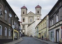
Around 1315 the so-called Bohemian Church was built, which was destroyed in the Hussite Wars and rebuilt in 1436 and after the Thirty Years War . In addition, the so-called German church was built between 1408 and 1411, which was rebuilt after the destruction by the Hussites in 1440 and rebuilt again in 1665. The Baroque pilgrimage church “Mariä Heimsuchung” was built on the site of these older churches between 1686 and 1704 under Abbot Augustin Neudeck and inaugurated on September 28, 1704 by Wroclaw Auxiliary Bishop Franz Engelbert Barbo von Waxenstein .
The pilgrims came not only from the Kamenz colleges, but also from Silesia, Moravia and Bohemia. The number of annual pilgrims was 170,000, and the Redemptorists took care of them from 1900 onwards. From 1905 they built the so-called Rosary Hill, on which many chapels with depictions of individual scenes from the rosary were built. Another part of the pilgrimage is the Marienkapelle, which was built on the summit of the 584 m high Warthaer Berg between 1617 and 1619.
After the annexation by the People's Republic of Poland in 1945, the importance of pilgrimages declined during communist rule. Nevertheless, the miraculous image was crowned on July 3, 1966 by the then Wroclaw Auxiliary Bishop Bolesław Kominek on July 3, 1966 . After the political change of 1989, the pilgrimage could develop freely again; today it again plays an important role in the religious life of Silesia.
Attractions
- Pilgrimage Church:
- The three-storey rectory, built from 1712 to 1716, now serves as a Redemptorist monastery and museum of sacred art.
- The stone bridge over the Glatzer Neisse comes from the 15th century.
- The Marienkapelle on the Warthaberg was built between 1617 and 1619.
- From 1905 to 1939, the Redemptorists erected several chapels on the so-called Rosary Hill, in which scenes from the Rosary are depicted.
- Wartha landslide , a still clearly visible massive rock fall from 1598
Population numbers
- 1840: 947 inhabitants, 907 of them Catholic
- 1885: 1,198, of which 1,164 were Catholic, 46 Protestant and 6 Jewish.
- 1933: 1.728
- 1939: 1.739
- 1945: 1.969
- 1950: 1,848
- 1957: 2,768
- 2007: 2,842
Gmina
The following places belong to the urban-and-rural municipality of Bardo:
- Bardo ( Wartha )
- Brzeźnica ( Briesnitz )
- Dębowina ( Eichau )
- Dzbanów ( Banau )
- Grochowa ( Grochau )
- Janowiec ( Johnsbach )
- Laskówka ( Gierichswalde )
- Opolnica ( Giersdorf )
- Potworów ( Riegersdorf )
- Przyłęk ( Frankenberg )
Personalities
- Fritz Mielert (1879–1947), photographer and local writer
- Georg Poppe (1883–1963), painter and graphic artist
- Gundolf Keil (* 1934), medical historian and Germanist
literature
- Hugo Weczerka (Hrsg.): Handbook of the historical places . Volume: Silesia (= Kröner's pocket edition . Volume 316). Kröner, Stuttgart 1977, ISBN 3-520-31601-3 , pp. 560-562.
- Dehio Handbook of Art Monuments in Poland Silesia . Munich / Berlin 2005, ISBN 3-422-03109-X , p. 116 f.
Web links
- City website
- Historical and current recordings as well as geographical location
- Virtual tour of the sanctuary
- Joachim Lukas: Notes on regional studies from Silesia - Wartha (accessed on November 16, 2016)
Individual evidence
- ^ A b Michael Rademacher: German administrative history from the unification of the empire in 1871 to the reunification in 1990. frankenstein.html. (Online material for the dissertation, Osnabrück 2006).
- ↑ Główny Urząd Statystyczny, "LUDNOŚĆ - STAN I STRUKTURA W PRZEKROJU TERYTORIALNYM", as of June 30, 2007 ( Memento of February 16, 2008 in the Internet Archive )


