
Tapfheim
| coat of arms | Germany map | |
|---|---|---|

|
Coordinates: 48 ° 40 ' N , 10 ° 41' E |
|
| Basic data | ||
| State : | Bavaria | |
| Administrative region : | Swabia | |
| County : | Danube Ries | |
| Height : | 415 m above sea level NHN | |
| Area : | 44.44 km 2 | |
| Residents: | 3828 (Dec. 31, 2019) | |
| Population density : | 86 inhabitants per km 2 | |
| Postal code : | 86660 | |
| Area code : | 09070 | |
| License plate : | DON, Lower Austria | |
| Community key : | 09 7 79 218 | |
| LOCODE : | DE TPF | |
| Community structure: | 19 parts of the community | |
| Address of the municipal administration: |
Ulmer Strasse 66 86660 Tapfheim |
|
| Website : | ||
| Mayor : | Karl Malz | |
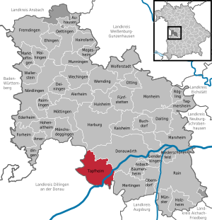
| Location of the municipality of Tapfheim in the Donau-Ries district | ||
  |
||

Tapfheim is a municipality in the Swabian district of Donau-Ries .
geography
location
The community is located on the Danube , about seven kilometers southwest of Donauwörth . Except for Rettingen, all districts are north of the Danube, in Rettingen the municipal area extends to the lower Zusam .
Parish parts
The municipality has 19 officially named municipal parts (the type of settlement is given in brackets ):
|
|
|
history
Until the church is planted


Tapfheim was first mentioned in a document between 750 and 800 on the occasion of gifts of goods to the Fulda monastery . The place was the seat of a lower nobility, the Lords of Tapfheim, which is attested from 1067 to 1401. The Augsburg bourgeois family Küchenmeister ("kitchen master of Tapfheim"), mentioned in a document in the second half of the 14th century, was linked to Tapfheim by special rights. Their coat of arms (unicorn body) was adopted in the seal of the Tapfheim court in the first half of the 16th century. After the Hofmark Tapfheim belonged to the Lords of Waldkirch towards the end of the 14th century , it was assigned to the newly founded Principality of Pfalz-Neuburg in 1505 . The Bavarian dukes and the princes of Pfalz-Neuburg appointed bailiffs as their administrators, who officiated in the Tapfheimer Schloss. There were close ecclesiastical relationships with the Cistercian monastery in Kaisheim between 1269 and 1803.

Incorporations
| Former parish |
coat of arms | Parish parts | Residents (1970) |
date | annotation |
|---|---|---|---|---|---|
| Fallow town |
|
Abtsholzerhof | 332 | 07/01/1972 | |
| Donaumünster |
|
Furtmühle | 599 | 07/01/1972 | Renaming on February 12, 1924 (previously Münster municipality ) |
| Erlingshofen |
|
601 | 07/01/1972 | ||
| Oppertshofen |
|
318 | 07/01/1972 | ||
| Zusum - rescue |
|
Bäldleschwaige, Bauernhansenschwaige, Birkschwaige, Dreiwinkelschwaige, Hubelschwaige, Hundeschwaige, Kilischwaige, Upper Hoserschwaige, Rothahnenschwaige and Lower Hoserschwaige | 215 | 07/01/1972 | Incorporation of 134 of the 215 residents, reclassification of the other residents to Donauwörth |
Population development
Between 1988 and 2018 the municipality grew from 3,487 to 3,879 by 392 inhabitants or by 11.2%.
politics
mayor
1. Mayor Karl Malz has been in office since 2004; he was re-elected on October 10, 2010 and October 9, 2016, with 96% of the votes, each with no opposing candidate. His predecessors were Alfred Stöckl (1986–2004) and Johannes Strasser (1972–1986), who subsequently (1986–2003) was a member of the Bavarian State Parliament .
Municipal council
The following are represented in the municipal council for the 2014 to 2020 electoral period:
- CSU with 5 seats
- SPD with 3 seats
- PWG with 4 seats
- UBG with 3 seats
- The left / alternative with 1 seat
In the local elections on March 15, 2020 , with a turnout of 63.2%, the following composition of the municipal council resulted for the term of office from 2020 to 2026:
- CSU with 5 seats
- SPD with 2 seats
- PWG with 4 seats
- UBG with 4 seats
- The left / alternative with 1 seat
Economy and Infrastructure
Commercial establishments
On June 30, 2017, according to official statistics, there were 454 employees subject to social insurance contributions at the place of work and 1,689 at the place of residence. This means that the number of out-commuters was 1235 higher than the number of in-commuters. 25 residents were unemployed.
In 2016 there were 60 farms; 2858 hectares of the community area were used for agriculture.
Four restaurants offer a total of 39 guest beds; In 2017, 7611 overnight stays were registered.
Council taxes
The main tax revenues in 2017, each in € 1000: property tax 447, trade tax (net) 756, municipal share of income tax 2551 and municipal share of sales tax 78.
traffic
The B 16 runs through Tapfheim and the districts of Donaumünster and Erlingshofen . There is a station on the Ingolstadt – Neuoffingen railway line at the site .
education
There are two day-care centers in the municipality with a total of 157 approved places; In 2018, 148 spaces were occupied. In 2018, the primary school attended 126 students in six classes. All secondary schools are in Donauwörth.
broadcast

The Tapfenturm is a 78 meter high transmission tower made of precast concrete, which is used to broadcast the radio program from hitradio.rt1 nordschwaben on 97.1 MHz with 100 W ERP.
Leisure, culture and sights
- Catholic Parish Church of St. Peter
Architectural monuments
Recreational facilities
The community library is located at the primary school. Almost 9,400 items of media (books, films, etc.) can be borrowed here. In addition, regular readings by authors and other smaller events related to books and films are held there.
Web links
- Entry on the coat of arms of Tapfheim in the database of the House of Bavarian History
- Tapfheim: Official statistics of the LfStat
- Official journal of the municipality of Tapfheim on tapfheim.de (PDF)
Individual evidence
- ↑ "Data 2" sheet, Statistical Report A1200C 202041 Population of the municipalities, districts and administrative districts 1st quarter 2020 (population based on the 2011 census) ( help ).
- ^ Community Tapfheim in the local database of the Bavarian State Library Online . Bayerische Staatsbibliothek, accessed on September 1, 2019.
- ↑ http://opac.winbiap.net/tapfheim/index.aspx

Alerheim | Amerdingen | Asbach-Bäumenheim | Auhausen | Buchdorf | Daiting | Deiningen | Donauwörth | Ederheim | Ehingen am Ries | Forheim | Fremdingen | Fünfstetten | Genderkingen | Hainsfarth | Harburg (Swabia) | Hohenaltheim | Holzheim | Huisheim | Kaisheim | Maihingen | Marktoffingen | Marxheim | Megesheim | Mertingen | Mönchsdeggingen | Monheim | Möttingen | Munningen | Munster | Niederschönenfeld | Nordlingen | Oberndorf am Lech | Oettingen in Bavaria | Otting | Rain | Reimlingen | Rögling | Tagmersheim | Tapfheim | Wallerstein | Wechingen | Wemding | Wolferstadt
Unregulated areas: Dornstadt-Linkersbaindt | Ester wood