
Gawler Kraton
The Gawler Craton is the oldest and largest geological crust block in South Australia (South Australia). It represents a complex tectonic unit that spanned a period from about 3,200 to 1,450 million years ago ( mya for short ). It consists of a meoarchaic to neoarchic core, which is surrounded by paleoproterozoic to mesoproterozoic rocks . The mesoarchaische phase is characterized by felsic magmatism while until Paleoproterozoic from neoarchean sedimentation and bimodal volcanism was prevalent. Felsic volcanism reappeared in the Mesoproterozoic. The Kraton had consolidated by 1450 mya.
Naming
This kraton was named after the second governor of South Australia , George Gawler .
Extension

Location of South Australia

Location of the Eyre and Yorke Peninsula


The southern border of the kraton coincides with the South Australian continental margin , but the other margins can hardly be defined because they are covered by massive rock sequences. The eastern edge forms the Neoproterozoic Torrens Hinge Zone, which is a transition zone between the thick, folded sediments in the Adelaide geosyncline and the shallow sediments of the same age of the craton and the Paleo- to Mesoproterozoic Curnamona Province. In the north and west, the Paleo to Neo-Proterozoic Officer Basin separates the craton from the Musgrave Province and the Albany Fraser Orogen and the Western Australian Yilgarn Kraton. The southern part of the craton is exposed in the Eyre and Yorke Peninsula .
Geological framework

Simplified geological map of the Mawson continent with the Gawler craton, Mawson craton the blue marked Terre Adélie craton and the red marked Miller Range

The Australian grawler kraton was once part of the Mawson continent. In addition to the Grawler-Kraton, this was made up of today's components: Terre Adélie-Kraton , Mawson-Kraton , Miller Range and the Shackleton Range . The amalgamation of these continental masses took place between 1730 and 1690 mya as part of the formation of the supercontinent Columbia .
The separation began in the Upper Jurassic around 160 mya with rift breaks, which led to the separation of Proto-Antarctic from Proto-Australia around 43 mya with the formation of a continuous ocean floor spread. The Gawler craton remained in Australia while the rest became part of Antarctica.
Geodynamic development and rocks

Geological map of Australia with the Gawler Craton marked in dark red in the central south

Geological map of the Gawler Craton


The Gawler Kraton went through a lengthy and complex geodynamic development. It covers a period from 3200 to 1450 mya, during which a multitude of different igneous, sedimentary, orogenic and metamorphic processes occurred.
- Basement and oldest rocks (Paleoarchean to Mesoarchean)
The oldest rock is the 3150 mya old Cooyerdoo granite in the northeast of the Eyre Peninsula . It developed during a Felsic Magmatism from melting of an already existing Tonalite - Trondhjemite - Granodiorite crust ( TTG complex ). Inherited zircons suggest that up to 3400 mya old, deep crustal material may be present, which forms the basement . The Cooyerdoo granite contains a gneiss - structure and 2510-2500 mya old metamorphic zircons known anywhere else in the Gawler Craton. They document the age of this rock development. Around 2800 mya, a protolith ( parent rock) intruded the basement from which the Coolanie gneiss developed. It emerged from granites of sedimentary origin. This is called S-type granite . The gneiss occurs in a north-south trending orogen in the Eyre Peninsula.
- Magmatism and sedimentary basin formation in southern and northern areas (Mesoarchean to Paleoproterozoic)
Between approx. 2560 and 2470 mya, sedimentary basins formed in the southern and northern areas of the kraton . In these thick layers of differently composed clastic sediments , band ores , carbonates and bimodal volcanics , consisting of felsic and mafic lavas , with komatiites were deposited . The deposition period dates between 2560 and 2555 mya. The rock packages formed the Sleaford Complex in the southern basin and the Mulgathing Complex in the northern basin. Presumably they were once a unit. Between 2465 and 2410 mya the Sleaford orogeny ended the deposits with deformations and metamorphic processes. Felsic magmatism appeared around 2000 mya, from which granite, granodiorite , charnockite and gneiss developed.
- Sedimentation and volcanism in eastern areas (Paleoproterozoic)
From 2000 to 1730 mya, a basin with a massive rock sequence consisting of quartzites , dolomites , ribbon iron, mica schists and amphibolites developed in the eastern craton area . They make up the Hutchison group. The deposit environment corresponded to a passive continental margin. The parent rocks were 2500 to 2000 mya old highly reclaimed and 1850 to 1790 mya old less developed crust springs.
Between 1850 and 1845 mya, the Cornian orogeny occurred on the Yorke Peninsula with deformations and extensive magmatic batholith intrusions. They made up the Donington Suite. This was followed by a phase of rift fractures and bimodal volcanism on the eastern rim of the craton. Over a period from 1790 to 1720 mya, clastic sediments were deposited in addition to volcanites.
Between 1730 and 1690 mya, the Kimban orrogens ended the previous phase in the eastern area. It produced low to high-grade metamorphoses of the deposited rocks, accompanied by different magmatism and the formation of several large-scale shear zones in the west and south. The Kalinjala Major Shear Zone is a dextral (right-hand) transpressive (combination of compression and shear), sub-vertical, highly stressed zone four to six kilometers wide that runs east along the Eyre Peninsula. It can be traced between Weednanna and the southern edge of the craton and separates the different lithostratigraphic rock units of the Hutchison group from the Donington suite. It is believed that the shear zone is a Geosutur represents that arose as a result of Kimban-Orogense.
- Sedimentation and volcanism in central and south-eastern areas (Paleoproterozoic)
In the central area of the craton, sedimentation and volcanism continued at the same time as the Kimban orogeny. Isolated basins, bounded by faults , developed in which basal conglomerates , quartzites and slate as well as rockic and mafic volcanic rocks were deposited. They form the Eba and Labyrinth formations , which date up to 1715 mya.
Sediment-based granites ( S-type granites ) and slightly mafic granites intruded over large areas of the kraton . They show weak to migmatitic metamorphic overprints and date between 1735 and 1690 mya. The best known is the Coober Pedy ridge in the north central area. This is home to a significant deposit of opals . In the central craton area, I-type granites occurred between 1690 and 1670 mya. These form an arched belt.
The Kimban orogeny was followed by a crustal expansion period between 1680 and 1640 mya, which led to local sedimentation and magmatism. There were fluvial conglomerates, sandstones and siltstones deposited the Corunna conglomerate on the Eyre Peninsula. This is up to 1680 mya. In the central craton area, sedimented sandstone schist, dolomite and Dazitic to andesitic volcanoclastic rocks of the Tarcoola Formation, which are up to 1655 mya old. From 1640 mya psammitic to pelitic sediments formed in the western craton area .
- Volcanism and crustal deformations in northern, central and southern areas (Paleoproterozoic to Mesoproterozoic)

In the southwestern part of the craton volcanoes erupted around 1630 mya Felsite . They were intruded between 1620 and 1615 mya by juvenile rockic to mafic magmas, which may have originated from island arc complexes. This phase was followed by persistent Felsic volcanism in the central part of the craton, probably in an originally remote backarc basin configuration. This produced the 1592 mya old, approx. 90,000 square kilometers large volcanic province of the Gawler Ranges . In an initial phase, these volcanic rocks consist of felsic and minor mafic magmas that arose from fractional crystallization and from mantle melts with crustal contamination. They were ejected from isolated volcanic centers. In the main phase, Felsic lavas erupted from extensive melts of the crust. They form a sequence of deposits from 200 to 300 m in thickness. The high-temperature fractionated felsic and slightly mafic intrusives of the 1595 to 1575 mya old Hiltaba suite appeared promptly. These come from depleted sources of the earth's mantle with a significant crustal component. In the Munjeela suite, granites of the sedimentary S-type developed around 1580 mya.
Magmatism of volcanoes the Gawler Ranges in the central part of the Kraton is connected to an upwardly Northwest / Southeast deformation with south vergent (inclined) folded blankets , as well as moderate to severe metamorphoses u. a. produced in the Coober Pedy Ridge in the northern Gawler Kraton. At the same time, metamorphoses from green slate facies to amphibolite facies and a folding in north / south-west direction occurred on the Yorke Peninsula in the southeastern craton . The deformations in the central craton area were divided into different shear zones.
The Kararan orogenesis occurred between 1570 and 1540 mya. It caused high grade metamorphoses with granulite facies and shear zone development and reactivation in the western and central northern areas of Gawler-Kraton. It could represent a later phase of deformations that occurred in the Gawler ranges and the Hiltaba suite.
After the Kararan orogeny between 1555 and 1500 mya there was slight local magmatism in the northern and southern areas of the Gawler craton.
The most recent event registered in the Gawler Craton reactivated between 1470 and 1450 mya shear zones with metamorphoses from green schist to amphibolite facies in the western craton area. Measurements indicate that the reactivation of shear zones was associated with regional denudation (erosion) of rock layers over most of the craton. With that the Gawler Kraton had consolidated.
Natural resources
The Gawler Kraton is rich in natural resources . These raw material deposits were created by different processes during the geodynamic development of the kraton. They accumulated in many deposits (see also → deposit history ). Economically important are ores , covering a wide range of metals contained and non-metallic raw materials such. B. graphites , kaolins , talc , magnesites , sandstones , limestones , dolomites, quartzites , granites , barytes . Precious stones are represented by opals jades , diamonds and chalcedones . Deposits that can be used for energy are uranium , thorium and coal .
Major mining areas and mines :

Main shafts of - Olympic Dam - Mine

Surface mining - mines in the Prominent Hill near Coober Pedy
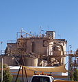
Structural works of the Challenger mine
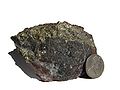
Chalcopyrite (chalcopyrite) in highly hämatitisierter breccia from the Olympic Dam - Mine


In the copper - gold -Provinz Eastern Olympic in the northeastern area of the craton is the large copper-gold Olympic Dam - Mine . The Prominent Hill Copper Gold Mine is northwest of Olympic Dam, while the Gold Challenger Mine is located west of Prominent Hill in about the middle of the craton. The copper-gold- molybdenum- Alkaroo mine is located on the eastern rim of the craton. It is mined in an optimized open-cast mine with a depth of approx. 230 m.
The Wynbring Area, much of the western Fowler Domain, extends for approximately 2,000 square kilometers and is composed of fractures that may include the intrusion of mafic-ultramafic intrusions with potential for nickel sulfides , chromites and platinum metals . Exploration and regional drilling at the northern end of the Fowler Domain and the Harris Greenstone Belt have identified numerous large mafic and ultramafic rock units suggestive of nickel sulfide mineralization . Ultramafic intrusive rocks with nickel-containing sulphides such as pentlandites and mackinawites contain values of up to 0.49 % nickel, 38 ppm platinum and 58 ppm palladium . Previous exploration samples returned up to 0.74% nickel from the top bedrock. These are sponsored by Mithril Resources Ltd. The Thompson Belt in Canada has similar characteristics and is believed to be a possible equivalent to the Fowler Domain.
Also in the Wynbring area, exploration suggests the occurrence of a 30 km long zone near a larger fault zone of medium to ultramafic rocks. These contain gold, nickel , chromium , platinum and palladium, which are exploited by PlatSearch NL.
Aerial photograph of the Beverley uranium mine

Processing plant of the Berverley uranium mine


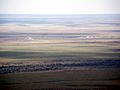
In the center of the craton, west of Prominent Hill , previous drilling in the Warrior Paleochan has confirmed significant, widespread uranium mineralization. An active uranium exploration is currently taking place there, extending into southern craton areas. The Warrior Paleochan is the most significant known uranium deposit in the Gawler Craton. It is sponsored by Stellar Resources Limited. Uranium was also mined in the Beverley uranium mine until 2013. It was roughly on the eastern edge of the craton.

View of the city of Coober Pedy

Entrances and excavation material from Opal mine shafts

Blower - a typical tool for opal mining

Opalised belemnite rust from the Upper Cretaceous by Coober Pedy, approx. 95 mya old

Underground housing complex in Coober Pedy


In the Coober Pedy Ridge, which extends roughly in the northern central area of the craton, the world's largest opal deposit was formed. The excavation takes place underground from shafts in further tunnels . Decommissioned mines are also used as extensive residential complexes because of the extremely hot climate .
Coal was extracted from the Telford Cut, an open pit mine. It is located in the Leigh Creek coal field, roughly in the eastern craton area. The inferior, sub- bituminous hard coal was extracted from 1943 to 2015 for heating purposes. closed in 2015. It was the only coal mine in South Australia.
Web links
- Gawler Craton Map Libery. In: Geosurveys Australia Pty Ltd, April 1999. Online article
- Stacey McAvaney, Stephan Thiel and Claire Wade: The Kalinjala Shear Zone, intracontinental shear zone or palaeosuture? In: Australian Earth Science Convention, Adelaide, June 29, 2016. PDF
Individual evidence
- ↑ Stacey McAvaney: Gawler Craton. In: Government of South Australia, Department for Energy and Mining. Online article
- ↑ Elinor Alexander: Arrowie Basin. In: Government of South Australia, Department for Energy and Mining. Online article
- ↑ MH Monroe: Adelaide geosyncline (Adelaide Rift Complex) ARC. In: Australia: The Land Where Time Began, A biography of the Australian continent. Online article
- ^ Wolfgang Preiss: Curnamona Province. In: Government of South Australia, Department for Energy and Mining. Online article
- ↑ Elinor Alexander: Officer Basin. In: Government of South Australia, Department for Energy and Mining. Online article
- ^ MH Monroe: Musgrave Province. In: Australia: The Land Where Time Began, A biography of the Australian continent. Online article
- ^ MH Monroe: Albany-Fraser Orogen, Western Australia - Transformation of the Margin of a Craton from the Archaean During Formation of a Basin and Magmatism in the Proterozoic. In: Australia: The Land Where Time Began, A biography of the Australian continent. Online article
- ^ MH Monroe: Yilgarn Craton, Western Australia. In: The Land Where Time Began, A biography of the Australian continent. Online article
- ↑ Justin L. Payne, Martin Hand, Karin M. Barovich, Anthony Reid, and David AD Evans: Correlations and reconstruction models for the 2500-1500 Ma evolution of the Mawson Continent. In: Palaeoproterozoic Supercontinents and Global Evolution. Geological Society, London, Special Publications, 323, 319-355. doi: 10.1144 / SP323.16 , PDF
- ^ Joanne M. Whittaker, Simon E. Williams and R. Dietmar Müller: Revised tectonic evolution of the Eastern Indian Ocean. In: Geochemistry, Geophysics, Geosystems, Volume 14, Issue 6, Pages: 1685-2062, June 2013. doi: 10.1002 / ggge.20120 , alternative
- ^ Anthony J. Reid, Stacey O. McAvaney, and Geoff L. Fraser: Nature of the Kimban Orogeny across northern Eyre Peninsula. In: MESA Journal 51 December 2008. PDF
- ↑ Katherine E Howard, Anthony J Reid, Martin P Hand, Karin M Barovich and Elena A Belousova: Does the Kalinjala Shear Zone represent a palaeosuture zone? Implications for distribution of styles of Mesoproterozoic mineralization in the Gawler Craton. In: MESA Journal 43 December 2006. PDF
- ^ Expanding Resources and improved Economics at Kalkaroo. In: Third Quarter Activities and Cash Flow Report, May 30, 2006. Online article
- ^ Report for the Quarter ending December 31, 2005. In: Mithril Recources. Online article
- ^ Announcement of Joint venture with INCO Wynbring Nickel Project, SA. In: PlatSearch NL, April 21, 2004. Online article
- ↑ Baohong Hou, Adrian J. Fabris, John L. Keeling and Martin C. Fairclough: Cainozoic palaeochannel-hosted uranium and current exploration methods, South Australia. In: MESA Journal 46 September 2007. PDF
- ↑ Chris Anderson: Paydirt's 2006 Uranium Conference. In: Stellar Resources Limited. Online article