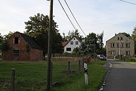
Grove (gera)
|
Grove
desert grove City of Gera
Coordinates: 50 ° 55 ′ 22 " N , 12 ° 5 ′ 58" E
|
|
|---|---|
| Height : | 302 m above sea level NN |
| Residents : | 229 (Dec. 31, 2013) |
| Incorporation : | July 1, 1994 |
| Postal code : | 07554 |
| Area code : | 036695 |
|
Village street in grove
|
|
Together with Wachholderbaum, Hain forms the 2.58 hectare village of Hain in the city of Gera in Thuringia with a total of 222 inhabitants (as of December 31, 2011).
geography
Hain is located in the north of the city of Gera near the border with Saxony-Anhalt .
history
The oldest known documentary mention dates back to 1191, in which a Volradus de Haen is named as a fellow witness. As part of the care Langenberg after its dissolution, Hain came into Wettin ownership together with Röpsen and parts of Roschütz and Dorna and remained there - most recently as part of the Duchy of Saxony-Altenburg - until the formation of the state of Thuringia in 1920 as an enclave in the middle of the Russian states .
Over the years, Röpsen has been the school and church location for Hain. Until the land reform in 1946, the economic center of the town was the manor - owned by the von Schauroth family for many years . In the time of Carl Friedrich von Schauroth (Colonel in the Saxon-Gotha Land Regiment), the remodeling of the Kempe , an old fortification, to an artistically valuable manor chapel and the creation of a baroque garden took place from 1693 .
In 1807 a von Brandenstein family became owners of the manor. In 1935 she sold it to the city of Gera, which in turn went to the German Reich, which set up a military training area on the extensive land. The chapel was demolished in 1938 because it was in a state of disrepair, the military training area was later used by the NVA and, since the fall of the Wall, by the Bundeswehr .
Apart from the manor there were small farms, the owners of which had to work on the estate as far as possible. With the land reform in 1946, the estate was broken up, parceled out and the stones from the demolished buildings were used to build ten new farmhouses. In the course of the collectivization of agriculture, the individual small businesses became an agricultural production cooperative (LPG).
In the years from 1945 to 1990 a central water supply, a consumption and a nurses' station were established. On July 1, 1950, the formerly independent community Wachholderbaum was incorporated into Hain.
As part of the law on the reorganization of the districts and independent cities in Thuringia, the independent municipality of Hain was incorporated into the city of Gera on July 1, 1994 after all legal means had been exhausted against the will of the residents.
politics
Grove with juniper tree has been incorporated into the city of Gera since October 1st, 1994. Since then, the two places have formed the Hain district of the city of Gera with its own local constitution and local council (until 2009 called local council).
District Mayor:
- 1994–2014 Roland Meinecke (SPD)
- 2014–2019 Dorothe Weil
- 2019 Lothar Korn (until June 30, 2019, resigned mayor of the district)
- 2019 Prof. Dr. Thomas Weil (until October 28, 2019, acting mayor of the district)
- 2019 Peter Ochs
Development of the population
| year | 1921 | 1939 | 2009 | 2013 |
| Residents | 72 | 191 | 164 | 229 |
traffic
Hain is close to Bundesstraße 2 . The public transport is through the RVG regional transport Gera / country secured. The place is connected to Gera with the hourly ring line 228.
The closest train station is Gera- Langenberg .
Sports
There is the Reitverein Hain eV in the village
education
The closest children's facility is the
- Daycare center Reichenbacher Straße in Kleinaga .
The responsible primary school is
- State primary school Aga in Kleinaga.
The closest regular school is the
- State regular school 12 in Bieblach -Ost.
literature
- Brodale, Klaus and Heidrun Friedemann: That was Gera in the 20th century. Gudensberg 2002.
- Hahn, Ferdinand: History of Gera and its immediate surroundings. Gera 1855.
- Klotz, Johann Christoph: Description of the rule and city of Gera. Schleiz 1816.
- Rosenkranz, Heinz: place names of the Gera district. Greiz 1982.
- Schiffner, Albert: Handbook of geography, statistics and topography of the Kgr. Saxony. Leipzig 1939.
- Schumann, August: Complete state, - post and newspaper lexicon for Saxony. Zwickau 1825.
- Spörl, Ulla and Frank Rüdiger: Gera in the Roaring Twenties. Gera 2007.
- Thuringian Pestalozziverein (Hrsg.): Thuringia in words and pictures. Berlin 1900. (Reprint; Augsburg 1997.)
- Announcements of the history and antiquity research association. Altenburg; div.
Web links
Individual evidence
- ↑ Gera city administration, FD 1200
- ↑ Municipalities in 1994 and their changes since January 1st, 1948 in the new federal states. Metzler-Poeschel publishing house, Stuttgart, 1995, ISBN 3-8246-0321-7 , publisher: Federal Statistical Office
- ↑ Gera City Archives

