Juniper tree
|
Juniper tree
City of Gera
Coordinates: 50 ° 55 ′ 58 " N , 12 ° 5 ′ 37" E
|
|
|---|---|
| Height : | 325 m above sea level NN |
| Residents : | 95 (Jan 1, 2009) |
| Incorporation : | July 1, 1950 |
| Incorporated into: | grove |
| Postal code : | 07554 |
| Area code : | 036695 |
|
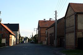
Main road to Hain in Wachholderbaum
|
|
Hain and Wachholderbaum together form the 2.58 hectare large village of Hain in the city of Gera in Thuringia with a total of 222 inhabitants (as of December 31, 2011).
geography
Wachholderbaum is located in the north of the city of Gera near the border with Saxony-Anhalt and directly on the Bundesstraße 2 Gera-Leipzig.
history
The settlement of Wachholderbaum developed from around 1700 around the Ausspann and the Altenburgischer Hof customs office on the trade route between Gera and Leipzig (today's B 2). It is listed as a municipality for the first time in 1718. Wachholderbaum, together with Hain, Röpsen , parts of Dorna and Roschütz, formed a Wettin enclave in the Principality of Reuss younger line belonging to the Duchy of Saxony-Altenburg until 1918 . The parish and school location was traditionally Röpsen.
On July 1, 1950, Wachholderbaum is incorporated into Hain.
As part of the law for the reorganization of the districts and independent cities in Thuringia , Wachholderbaum and Hain were incorporated into the city of Gera in 1994 after all legal means had been exhausted against the will of the residents.
politics
Since 1994, the two places have formed the Hain district of the city of Gera with its own local constitution and local council (until II / 2009 local council) . The district mayor has been Roland Meinecke (SPD) since 1994.
Development of the population
| year | 1933 | 1939 | 2009 |
| Residents | 123 | 126 | 95 |
traffic
Juniper tree is located near federal highway 2 . The public transport is through the RVG regional transport Gera / country secured. The place is connected to Gera with the hourly ring line 228.
The closest train station is Gera- Langenberg .
Culture
The Hain-Wachholderbaum volunteer fire brigade , together with the local council, organizes village festivals, in particular the annual maypole setting.
education
The closest children's facility is the
- Daycare center Reichenbacher Straße in Kleinaga.
The responsible primary school is
- State primary school Aga in Kleinaga.
The closest regular school is the
- State regular school 12 in Bieblach-Ost.
literature
- Brodale, Klaus and Heidrun Friedemann: That was Gera in the 20th century. Gudensberg 2002.
- Rosenkranz, Heinz: place names of the Gera district. Greiz 1982.
- Schiffner, Albert: Handbook of geography, statistics and topography of the Kgr. Saxony. Leipzig 1939.
- Schumann, August: Complete State, Post and Newspaper Lexicon for Saxony. Zwickau 1825.
- Announcements of the history and antiquity research association. Altenburg; div.
Web links
Individual evidence
- ↑ Gera city administration, FD 1200
- ↑ Municipalities 1994 and their changes since January 1, 1948 in the new federal states , Metzler-Poeschel publishing house, Stuttgart, 1995, ISBN 3-8246-0321-7 , publisher: Federal Statistical Office
- ↑ Gera City Archives

